
Northside, Lexington: Difference between revisions
Content deleted Content added
Lightmouse (talk | contribs) Mostly units using AWB (7069) |
HouseBlaster (talk | contribs) merge Template:Fayette County/Lexington neighborhoods ahead of its merger with Lexington (Kentucky) per Wikipedia:Templates for discussion/Log/2023 October 11#Template:Fayette County/Lexington neighborhoods (via WP:JWB) |
||
| (21 intermediate revisions by 13 users not shown) | |||
| Line 1: | Line 1: | ||
{{more citations needed|date=May 2011}} |
|||
'''Northside''' is a neighborhood in northern [[Lexington, Kentucky]], [[United States]]. Its boundaries are Loudon Avenue to the north and east, Short Street, Midland Avenue, and Winchester Road to the south, and Newtown Pike to the west. It is Lexington's most impoverished and crime ridden area. |
|||
{{Infobox settlement |
|||
In 2000 Northside had a population of 9,358. It is composed of Fayette County census tracts 2, 3, and 4. |
|||
|official_name = Northside |
|||
|settlement_type = [[:Category:Neighborhoods in Lexington, Kentucky|Neighborhood of Lexington, Kentucky]] |
|||
|nickname = |
|||
|motto = |
|||
<!-- Images --> |
|||
Neighborhood statistics |
|||
|image_skyline = 3rdStNLex.jpg |
|||
* Population in 2000: 9,358 |
|||
|imagesize = 200 |
|||
* Land area: {{convert|1.49|sqmi|km2}} |
|||
|image_caption = A residential neighborhood in Lexington's Northside |
|||
* Population density: 6,280 persons per sq mile |
|||
|image_flag = |
|||
* Median household income: $17,679 |
|||
|image_seal = |
|||
<!-- Maps --> |
|||
==External Links== |
|||
|image_map = |
|||
|mapsize = |
|||
|map_caption = |
|||
|image_map1 = |
|||
|mapsize1 = |
|||
|map_caption1 = |
|||
<!-- Location --> |
|||
{{coord missing|Kentucky}} |
|||
|subdivision_type = [[List of sovereign states|Country]] |
|||
|subdivision_name = United States |
|||
|subdivision_type1 = [[U.S. state|State]] |
|||
|subdivision_name1 = [[Kentucky]] |
|||
|subdivision_type2 = [[List of counties in Kentucky|County]] |
|||
|subdivision_name2 = [[Fayette County, Kentucky|Fayette]] |
|||
|subdivision_type3 = [[List of cities in Kentucky|City]] |
|||
|subdivision_name3 = [[Lexington, Kentucky|Lexington]] |
|||
|government_footnotes = |
|||
|government_type = |
|||
|leader_title = |
|||
|leader_name = |
|||
|leader_title1 = |
|||
|leader_name1 = |
|||
|established_title = |
|||
|established_date = |
|||
|established_title1 = |
|||
|established_date1 = |
|||
<!-- Area --> |
|||
|unit_pref = Imperial |
|||
|area_footnotes = |
|||
|area_magnitude = |
|||
|area_total_km2 = 1.48 |
|||
|area_land_km2 = |
|||
|area_water_km2 = |
|||
|area_total_sq_mi = 0.572 |
|||
|area_land_sq_mi = |
|||
|area_water_sq_mi = |
|||
<!-- Population --> |
|||
|population_as_of = [[United States Census, 2000|2000]] |
|||
|population_footnotes = |
|||
|population_total = 3,875 |
|||
|population_density_km2 = 2,618.2 |
|||
|population_density_sq_mi = 6,774 |
|||
<!-- General information --> |
|||
|timezone = [[North American Eastern Time Zone|Eastern (EST)]] |
|||
|utc_offset = -5 |
|||
|timezone_DST = EDT |
|||
|utc_offset_DST = -4 |
|||
|elevation_footnotes = |
|||
|elevation_m = |
|||
|elevation_ft = |
|||
|coordinates = |
|||
<!-- Area/postal codes & others --> |
|||
|postal_code_type = [[ZIP code]] |
|||
|postal_code = 40507, 40508 |
|||
|area_code = [[Area code 859|859]] |
|||
|blank_name = |
|||
|blank_info = |
|||
|blank1_name = |
|||
|blank1_info = |
|||
|website = |
|||
|footnotes = |
|||
}} |
|||
'''Northside''' is a neighborhood in northern [[Lexington, Kentucky]], United States. Its boundaries are Loudon Avenue to the north and east, Short Street, Midland Avenue, and Winchester Road to the south, and Newtown Pike to the west.<ref name=data>[http://www.city-data.com/neighborhood/Northside-Historic-Residential-Lexington-KY.html Northside Neighborhood Profile] city-data.com. Retrieved on 2011-01-01</ref> |
|||
==Neighborhood statistics== |
|||
* Population in 2000: 3,875 |
|||
* Land area: {{convert|0.572|sqmi|km2}} |
|||
* Population density: {{convert|6,774|/mi2|/km2|disp=preunit|people |people}} |
|||
* Median household income: $26,159<ref name=data/> |
|||
==Gallery== |
|||
Numerous buildings and corridors in Lexington's Northside neighborhood are on the [[National Register of Historic Places listings in Fayette County, Kentucky|National Register of Historic Places]], including: |
|||
<gallery class="center" mode=packed heights="150px"> |
|||
File:Matthew Kennedy House.jpg|Matthew Kennedy House |
|||
File:McCracken-Wilgus House.jpg|McCracken-Wilgus House |
|||
File:Russell School in Lexington.jpg|Russell School |
|||
</gallery> |
|||
==References== |
|||
{{reflist}} |
|||
{{Fayette County/Lexington, Kentucky}} |
|||
{{Authority control}} |
|||
{{coord|38|03|N|84|29|W|region:US-KY_scale:20000|display=title}} |
|||
[[Category:Neighborhoods in Lexington, Kentucky]] |
[[Category:Neighborhoods in Lexington, Kentucky]] |
||
Latest revision as of 20:16, 2 December 2023
This article needs additional citations for verification. (May 2011) |
Northside | |
|---|---|
 A residential neighborhood in Lexington's Northside | |
| Country | United States |
| State | Kentucky |
| County | Fayette |
| City | Lexington |
| Area | |
| • Total | 0.572 sq mi (1.48 km2) |
| Population (2000) | |
| • Total | 3,875 |
| • Density | 6,774/sq mi (2,618.2/km2) |
| Time zone | UTC-5 (Eastern (EST)) |
| • Summer (DST) | UTC-4 (EDT) |
| ZIP code | 40507, 40508 |
| Area code | 859 |
Northside is a neighborhood in northern Lexington, Kentucky, United States. Its boundaries are Loudon Avenue to the north and east, Short Street, Midland Avenue, and Winchester Road to the south, and Newtown Pike to the west.[1]
Neighborhood statistics
[edit]- Population in 2000: 3,875
- Land area: 0.572 square miles (1.48 km2)
- Population density: 6,774 people per square mile (2,615 people/km2)
- Median household income: $26,159[1]
Gallery
[edit]Numerous buildings and corridors in Lexington's Northside neighborhood are on the National Register of Historic Places, including:
-
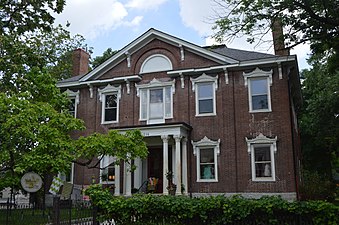 Matthew Kennedy House
 -
 McCracken-Wilgus House
 -
 Russell School


References
[edit]- ^ a b Northside Neighborhood Profile city-data.com. Retrieved on 2011-01-01


