
Medzilaborce: Difference between revisions
No edit summary |
Some details |
||
| (40 intermediate revisions by 29 users not shown) | |||
| Line 1: | Line 1: | ||
{{Infobox settlement |
|||
{{Geobox|Settlement |
|||
| name = Medzilaborce |
|||
<!-- *** Heading *** --> |
|||
| native_name = |
|||
| name = Medzilaborce |
|||
| other_name = |
|||
| category = Town |
|||
| settlement_type = Town |
|||
<!-- *** Names **** --> |
|||
<!-- images, nickname, motto --> |
|||
| etymology = "people amidst the [[Laborec]] streams" |
|||
| image_skyline = Medzilaborce main street.jpg |
|||
| official_name = |
|||
| image_caption = Medzilaborce main street |
|||
| motto = |
|||
| image_flag = |
|||
| nickname = |
|||
| image_shield = Coat of Arms of Medzilaborce.svg |
|||
<!-- *** Image *** --> |
|||
| |
| motto = |
||
| nickname = |
|||
| image_caption = Medzilaborce main street |
|||
| etymology = "people amidst the [[Laborec]] streams" |
|||
<!-- *** Symbols *** --> |
|||
<!-- location --> |
|||
| flag = |
|||
| subdivision_type = [[List of sovereign states|Country]] |
|||
| symbol = Coat of arms of Medzilaborce.png |
|||
| subdivision_name = {{SVK}} |
|||
| symbol_type = |
|||
| subdivision_type1 = |
|||
<!-- *** Country *** --> |
|||
| subdivision_name1 = |
|||
| country = Slovakia |
|||
| subdivision_type2 = [[Regions of Slovakia|Region]] |
|||
| country_flag = true |
|||
| subdivision_name2 = [[Prešov Region|Prešov]] |
|||
| state = |
|||
| subdivision_type3 = [[Districts of Slovakia|District]] |
|||
| region = [[Prešov Region|Prešov]] |
|||
| |
| subdivision_name3 = [[Medzilaborce District|Medzilaborce]] |
||
| subdivision_type4 = |
|||
| municipality = |
|||
| subdivision_name4 = |
|||
<!-- *** Family *** --> |
|||
<!-- maps and coordinates --> |
|||
| landmark = |
|||
| image_map = |
|||
| river = Laborec |
|||
| map_caption = |
|||
<!-- *** Locations *** --> |
|||
| pushpin_map = Slovakia Prešov Region#Slovakia |
|||
| location = |
|||
| pushpin_relief = 1 |
|||
| elevation = 326 |
|||
| pushpin_map_caption = Location in Prešov Region##Location in Slovakia |
|||
| prominence = |
|||
| coordinates = {{coord|49|16|15|N|21|54|14|E|display=inline,title}} |
| coordinates = {{coord|49|16|15|N|21|54|14|E|display=inline,title}} |
||
| coordinates_footnotes = |
|||
| capital_coordinates = |
|||
<!-- government type, leaders --> |
|||
| mouth_coordinates = |
|||
| leader_title = Mayor |
|||
| highest = |
|||
| leader_name = Vladislav Višňovský |
|||
| highest_location = | highest_region = | highest_state = |
|||
<!-- established --> |
|||
| highest_elevation = |
|||
| established_title = First mentioned |
|||
| lowest = |
|||
| established_date = 1557 |
|||
| lowest_location = | lowest_region = | lowest_state = |
|||
<!-- area --> |
|||
| lowest_elevation = |
|||
| area_footnotes =<ref>{{cite web |url=https://datacube.statistics.sk/#!/view/sk/VBD_DEM/om7014rr/v_om7014rr_00_00_00_sk |title=Hustota obyvateľstva - obce |author=Statistical Office of the Slovak Republic (www.statistics.sk) |date= |website=www.statistics.sk |publisher= |access-date=2024-02-08}}</ref> |
|||
| length = | length_orientation = |
|||
| area_total_km2 = 47.48 |
|||
| width = | width_orientation = |
|||
| area_total_sq_mi = |
|||
| area = 47.479 |
|||
| area_land_sq_mi = |
|||
| area_land = |
|||
| area_water_sq_mi = |
|||
| area_water = |
|||
<!-- elevation --> |
|||
| area_urban = |
|||
| elevation_footnotes = |
|||
| area_metro = |
|||
| elevation_m = 342<ref name="base_info">{{Cite web |url=http://datacube.statistics.sk/#!/view/sk/VBD_SK_WIN/om5001rr/v_om5001rr_00_00_00_sk |title=Základná charakteristika |language=sk |date=2015-04-17 |website=www.statistics.sk |publisher= Statistical Office of the Slovak Republic|access-date=2022-03-31}}</ref> |
|||
<!-- *** Population *** --> |
|||
| elevation_ft = 1,122<ref name="base_info"/> |
|||
| population =6616 | population_date = 31 December 2006 |
|||
| population_as_of = {{Tooltip|2022|2022-12-31}} |
|||
| population_urban = |
|||
| population_footnotes =<ref>{{cite web |url=https://datacube.statistics.sk/#!/view/sk/VBD_DEM/om7101rr/v_om7101rr_00_00_00_sk |title=Počet obyvateľov podľa pohlavia - obce (ročne) |author=Statistical Office of the Slovak Republic (www.statistics.sk) |date= |website=www.statistics.sk |publisher= |access-date=2024-02-08}}</ref> |
|||
| population_metro = |
|||
| population_total = 5806 |
|||
| population_density = auto |
|||
| population_density_km2 = auto |
|||
| population_density_urban = |
|||
| population_density_sq_mi= |
|||
| population_density_metro = |
|||
| population_demonym = |
|||
<!-- *** History & management *** --> |
|||
<!-- time zone(s) --> |
|||
| established =1557 |
|||
| timezone1 = [[Central European Time|CET]] |
|||
| established_type = First mentioned |
|||
| utc_offset1 = +1 |
|||
| date = |
|||
| timezone1_DST = [[Central European Summer Time|CEST]] |
|||
| government = |
|||
| utc_offset1_DST = +2 |
|||
| government_location = | government_region = | government_state = |
|||
<!-- postal codes, area code --> |
|||
| government_elevation = |
|||
| postal_code_type = Postal code |
|||
| mayor = Ladislav Demko |
|||
| postal_code = 068 01<ref name="base_info"/> |
|||
| leader = |
|||
| area_code_type = |
|||
<!-- *** Codes *** --> |
|||
| area_code = +421 57<ref name="base_info"/> |
|||
| timezone =[[Central European Time|CET]] | utc_offset =+1 |
|||
| geocode = |
|||
| timezone_DST =[[Central European Summer Time|CEST]] | utc_offset_DST =+2 |
|||
| iso_code = |
|||
| postal_code = 068 01 |
|||
| blank_name = [[Slovak car registration plates|Car plate]] |
|||
| area_code = 421-57 |
|||
| blank_info = ML |
|||
| area_code_type = Phone prefix |
|||
<!-- website, footnotes --> |
|||
| code = ML |
|||
| website = {{url|www.medzilaborce-urad.sk}} |
|||
| code_type = [[Slovak car registration plates|Car plate]] |
|||
| footnotes = |
|||
<!-- *** UNESCO etc. *** --> |
|||
|area_note= ({{Tooltip|2022|2022-06-31/2022-07-01}}) |
|||
| whs_name = |
|||
| whs_year = |
|||
| whs_number = |
|||
| whs_region = |
|||
| whs_criteria = |
|||
| iucn_category = |
|||
<!-- *** Free fields *** --> |
|||
| free = | free_type = |
|||
<!-- *** Maps *** --> |
|||
| map =Slovakia - outline map.svg |
|||
| map_caption = Location in Slovakia |
|||
| map_background = Slovakia - background map.png |
|||
| map_locator = Slovakia |
|||
| map1 =Prešov Region - outline map.svg |
|||
| map1_caption = Location in the Prešov Region |
|||
| map1_background = Prešov Region - background map.png |
|||
| map1_locator = Prešov Region |
|||
<!-- *** Website *** --> |
|||
| commons = Medzilaborce |
|||
| statistics = [http://www.statistics.sk/mosmis/eng/prvav2.jsp?txtUroven=440705&lstObec=520471&Okruh=zaklad MOŠ/MIS]{{dead link|date=June 2017 |bot=InternetArchiveBot |fix-attempted=yes }} |
|||
| website = http://www.medzilaborce.net |
|||
<!-- *** Footnotes *** --> |
|||
| footnotes = |
|||
}} |
}} |
||
'''Medzilaborce''' ({{lang- |
'''Medzilaborce''' ({{lang-rue|Міджілабірцї}}, ''Midzhilabirtsyi''; {{lang-uk|Міжлабірці}}, ''Mizhlabirtsi''; {{lang-hu|Mezőlaborc}}) is a [[List of towns in Slovakia|town]] in northeastern [[Slovakia]] close to the border with [[Poland]], located near the towns of [[Sanok]] and [[Bukowsko]] (in southeastern [[Małopolska]]). Its population is approximately 6,500. |
||
==Characteristics== |
==Characteristics== |
||
It is an administrative and cultural centre of the [[Laborec]] Region. A train line connects it with the town of Humenné to the south and with Poland to the north. The private sector and service industries are developing quickly in the town at the moment. |
It is an administrative and cultural centre of the [[Laborec]] Region. A train line connects it with the town of Humenné to the south and with Poland to the north. The private sector and service industries are developing quickly in the town at the moment. |
||
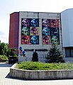
It is home to the [[Andy Warhol Museum of Modern Art]], opened in 1991, which contains many artworks and effects of [[Andy Warhol]] |
It is home to the [[Andy Warhol Museum of Modern Art]], opened in 1991, which contains many artworks and effects of [[Andy Warhol]], his brother Paul and nephew [[James Warhola]]. Warhol's mother, [[Julia Warhola]], was born and lived with her husband in the village of [[Miková|Mikó]] (today Miková), {{convert|17|km|0|abbr=off}} to the west. |
||
Medzilaborce is situated in one of the least developed regions of Slovakia. There are three churches in the town. |
Medzilaborce is situated in one of the least developed regions of Slovakia. There are three churches in the town. |
||
| Line 113: | Line 91: | ||
==History== |
==History== |
||
The oldest written record connected with Medzilaborce dates back to 1543. The village first belonged to the Drugeth family, but passed to the Csáky family in the 17th century and later in the 19th century to the |
The oldest written record connected with Medzilaborce dates back to 1543. The village first belonged to the Drugeth family, but passed to the Csáky family in the 17th century and later in the 19th century to the Andrássy family manor. As early as the 17th century, an important trade route passed through Medzilaborce connecting the interior of Slovakia with Poland through the [[Lupkov Pass]]. Medzilaborce became a town in 1860.<ref>{{cite web |url=http://www.medzilaborce.net/medzilaborce_1.htm |title=Medzilaborce |access-date=2007-10-01 |url-status=dead |archive-url=https://web.archive.org/web/20051124041555/http://www.medzilaborce.net/medzilaborce_1.htm |archive-date=2005-11-24 }} (Slovak)</ref> In 1873, construction of the train track between [[Humenné|Homonna]] (present-day Humenné) and Medzilaborce and further on to [[Galicia (Central Europe)|Galicia]] via the [[Lupkov Pass]], which contributed to the growth of the town from 724 inhabitants in 1851 to 1561 citizens in 1910. During [[World War I]], Russian troops entered the town in February 1915 and stayed there until May 1915, leaving the town significantly damaged. Before the establishment of independent [[Czechoslovakia]] in 1918, it was part of [[Zemplén County]] within the [[Kingdom of Hungary]]. In 1918 the town became part of Czechoslovakia. During the [[History of Czechoslovakia (1918–1938)|first Czechoslovak republic]], there was massive unemployment, and many people emigrated from the town. From 1939 to 1944, Medzilaborce was part of the [[Slovak Republic (1939–1945)|Slovak Republic]]. The town was significantly damaged again during [[World War II]], when 30% of the population of the city, consisting of Jewish Slovaks, were executed or sent to concentration camps. On 26 November 1944, the [[Red Army]] and the [[1st Czechoslovak Army Corps in the Soviet Union|1st Czechoslovak Army Corps]] dislodged the [[Wehrmacht]] from Medzilaborce and it was once again part of Czechoslovakia. It was the seat of the district until 1960, when it was merged with the Humenné district. It has again been the seat of the Medzilaborce district since 1996. |
||
==Demographics== |
==Demographics== |
||
In 1910 the town had 1,561 inhabitants, 677 Ruthenian, 501 [[Germans|German]] and 255 [[Hungarian people|Hungarian]]. More than one third of the population (34.3%) were Jewish. The town had a high percentage of [[Rusyns]] before [[World War II]]. |
In 1910 the town had 1,561 inhabitants, 677 Ruthenian, 501 [[Germans|German]] and 255 [[Hungarian people|Hungarian]]. More than one third of the population (34.3%) were Jewish. The town had a high percentage of [[Rusyns]] before [[World War II]]. |
||
According to the 2001 [[census]], the town had 6,741 inhabitants. 56.42% of inhabitants were [[Slovaks]], 34.16% [[Rusyns]], 6.13% [[Ukrainian people|Ukrainian]], 1.11% [[Romani people|Roma]] and 0.68% [[Czech people|Czechs]].<ref name="statistics">{{cite web | title = Municipal Statistics | publisher = Statistical Office of the Slovak republic | url = http://www.statistics.sk/mosmis/eng/run.html | |
According to the 2001 [[census]], the town had 6,741 inhabitants. 56.42% of inhabitants were [[Slovaks]], 34.16% [[Rusyns]], 6.13% [[Ukrainian people|Ukrainian]], 1.11% [[Romani people|Roma]] and 0.68% [[Czech people|Czechs]].<ref name="statistics">{{cite web | title = Municipal Statistics | publisher = Statistical Office of the Slovak republic | url = http://www.statistics.sk/mosmis/eng/run.html | access-date = 2008-02-17 |archive-url = https://web.archive.org/web/20080208225314/http://www.statistics.sk/mosmis/eng/run.html <!-- Bot retrieved archive --> |archive-date = 2008-02-08}}</ref> The religious makeup was 41.15% [[Greek Catholics]], 40.07% [[Eastern Orthodox Church|Orthodox]], 4.94% people with no religious affiliation, 10.15% [[Roman Catholics]] and 0.33% [[Lutherans]].<ref name="statistics"/> |
||
==Economy and infrastructure== |
==Economy and infrastructure== |
||
Glass and machinery industry have the largest tradition in town Medzilaborce. |
Glass and machinery industry have the largest tradition in town Medzilaborce. |
||
From 1970s it had been a branch of Jablonecke sklarne which had employ approximately 600 people in the glass industry. Company has stop its operations after privatization. [[Glass LPS]] has been now a follower of |
From 1970s it had been a branch of Jablonecke sklarne which had employ approximately 600 people in the glass industry. Company has stop its operations after privatization. [[Glass LPS]] has been now a follower of 45 years old tradition in glass industry in Medzilaborce and still manufacture crystal chandeliers and grind crystal trimmings. |
||
In machinery industry in Medzilaborce it was Transporta, later Vihorlat which had 1200 employees. Privatization and crises had destroyed the whole factory. Nowadays companies Kovostroj and Labstroj continue in machinery industry. |
In machinery industry in Medzilaborce it was Transporta, later Vihorlat which had 1200 employees. Privatization and crises had destroyed the whole factory. Nowadays companies Kovostroj and Labstroj continue in machinery industry. |
||
| Line 134: | Line 112: | ||
==Twin towns — sister cities== |
==Twin towns — sister cities== |
||
{{See also|List of twin towns and sister cities in Slovakia}} |
|||
Medzilaborce is [[Twin towns and sister cities|twinned]] with:<ref>{{cite web |title= Přátelství a spolupráce s městem Medzilaborce|url=http://www.namestnosl.cz/partnerska%2Dmesta/d-2739/p1=2577|website= namestnosl.cz|publisher=Náměšť nad Oslavou|language=cs|access-date=2019-09-05}}</ref><ref>{{cite web |title=Współpraca zagraniczna|url=http://www.kozienice.pl/strona-173-wspolpraca_z_zagranica.html|website=kozienice.pl|publisher=Kozienice|language=pl|access-date=2019-09-05}}</ref> |
|||
* {{flagicon|CZE}} [[Náměšť nad Oslavou]], Czech Republic |
|||
* |
*{{flagicon|CZE}} [[Náměšť nad Oslavou]], Czech Republic |
||
*{{flagicon|POL}} [[Kozienice]], Poland |
|||
==Museum of Modern Art== |
==Museum of Modern Art== |
||
| Line 147: | Line 126: | ||
File:Medzilaborce-muzeum2.jpg|The Andy Warhol Museum of Modern Art |
File:Medzilaborce-muzeum2.jpg|The Andy Warhol Museum of Modern Art |
||
File:Medzilaborce-warhol.jpg|Statue of Andy Warhol |
File:Medzilaborce-warhol.jpg|Statue of Andy Warhol |
||
File:Medzilaborce- |
File:Medzilaborce-Eglise du St-Esprit.jpg|Orthodox church in the center of Medzilaborce |
||
</gallery> |
</gallery> |
||
| Line 154: | Line 133: | ||
==External links== |
==External links== |
||
{{Commons category|Medzilaborce}} |
* {{Commons category-inline|Medzilaborce}} |
||
* {{Official website}} |
|||
* [http://www.medzilaborce.net/ Unofficial website of Medzilaborce] {{sk icon}} |
|||
* [http://www.medzilaborce.net/ Unofficial website of Medzilaborce] {{in lang|sk}} |
|||
* [http://www.spectacularslovakia.sk/ss2002/medzilaborce.html Medzilaborce: Modern art in a desolate town] by Chris Togneri for the [http://www.spectacularslovakia.sk/ Spectacular Slovakia] travel guide |
|||
* [https://web.archive.org/web/20060902154535/http://www.spectacularslovakia.sk/ss2002/medzilaborce.html Medzilaborce: Modern art in a desolate town] by Chris Togneri for the [https://web.archive.org/web/20071013020522/http://www.spectacularslovakia.sk/ Spectacular Slovakia] travel guide |
|||
* [https://web.archive.org/web/20100506012511/http://www.grkat-ml.sk/ Catholic church of Byzantine rite in Medzilaborce] |
* [https://web.archive.org/web/20100506012511/http://www.grkat-ml.sk/ Catholic church of Byzantine rite in Medzilaborce] |
||
* [http://www.warholcity.com The Andy Warhol Museum of Modern Art - city of origin] |
* [http://www.warholcity.com The Andy Warhol Museum of Modern Art - city of origin] |
||
* [http://www.slovakia.org/culture-warhol.htm Andy Warhol in Slovakia] by Robert Rigney |
* [https://web.archive.org/web/20120912051617/http://www.slovakia.org/culture-warhol.htm Andy Warhol in Slovakia] by Robert Rigney |
||
{{wide image|Medzilaborce-panorama.jpg|900px|align-cap=center|'''Main street in Medzilaborce. The Warhol Museum of Modern Art can be seen on the left'''}} |
{{wide image|Medzilaborce-panorama.jpg|900px|align-cap=center|'''Main street in Medzilaborce. The Warhol Museum of Modern Art can be seen on the left'''}} |
||
| Line 168: | Line 148: | ||
[[Category:Cities and towns in Slovakia]] |
[[Category:Cities and towns in Slovakia]] |
||
[[Category:Geography of Prešov Region]] |
|||
[[Category:Villages and municipalities in Medzilaborce District]] |
[[Category:Villages and municipalities in Medzilaborce District]] |
||
[[Category:Zemplín (region)]] |
|||
[[Category:Rusyn communities]] |
|||
Latest revision as of 17:51, 22 June 2024
Medzilaborce | |
|---|---|
Town | |
 Medzilaborce main street | |
 Coat of arms | |
| Etymology: "people amidst the Laborec streams" | |
 Medzilaborce Location in Prešov Region  Medzilaborce Location in Slovakia | |
| Coordinates: 49°16′15″N 21°54′14″E / 49.27083°N 21.90389°E | |
| Country | |
| Region | Prešov |
| District | Medzilaborce |
| First mentioned | 1557 |
| Government | |
| • Mayor | Vladislav Višňovský |
| Area | |
| • Total | 47.48 km2 (18.33 sq mi) |
| (2022) | |
| Elevation | 342[2] m (1,122[2] ft) |
| Population | |
| • Total | 5,806 |
| • Density | 120/km2 (320/sq mi) |
| Time zone | UTC+1 (CET) |
| • Summer (DST) | UTC+2 (CEST) |
| Postal code | 068 01[2] |
| Area code | +421 57[2] |
| Car plate | ML |
| Website | www |
Medzilaborce (Rusyn: Міджілабірцї, Midzhilabirtsyi; Ukrainian: Міжлабірці, Mizhlabirtsi; Hungarian: Mezőlaborc) is a town in northeastern Slovakia close to the border with Poland, located near the towns of Sanok and Bukowsko (in southeastern Małopolska). Its population is approximately 6,500.
Characteristics
[edit]It is an administrative and cultural centre of the Laborec Region. A train line connects it with the town of Humenné to the south and with Poland to the north. The private sector and service industries are developing quickly in the town at the moment.
It is home to the Andy Warhol Museum of Modern Art, opened in 1991, which contains many artworks and effects of Andy Warhol, his brother Paul and nephew James Warhola. Warhol's mother, Julia Warhola, was born and lived with her husband in the village of Mikó (today Miková), 17 kilometres (11 miles) to the west.
Medzilaborce is situated in one of the least developed regions of Slovakia. There are three churches in the town.
Geography
[edit]City parts:
The town of Medzilaborce lies in the valley of the Laborec river in north-eastern Slovakia. The hills of the surrounding Laborec Highlands are typical of this countryside.
History
[edit]The oldest written record connected with Medzilaborce dates back to 1543. The village first belonged to the Drugeth family, but passed to the Csáky family in the 17th century and later in the 19th century to the Andrássy family manor. As early as the 17th century, an important trade route passed through Medzilaborce connecting the interior of Slovakia with Poland through the Lupkov Pass. Medzilaborce became a town in 1860.[4] In 1873, construction of the train track between Homonna (present-day Humenné) and Medzilaborce and further on to Galicia via the Lupkov Pass, which contributed to the growth of the town from 724 inhabitants in 1851 to 1561 citizens in 1910. During World War I, Russian troops entered the town in February 1915 and stayed there until May 1915, leaving the town significantly damaged. Before the establishment of independent Czechoslovakia in 1918, it was part of Zemplén County within the Kingdom of Hungary. In 1918 the town became part of Czechoslovakia. During the first Czechoslovak republic, there was massive unemployment, and many people emigrated from the town. From 1939 to 1944, Medzilaborce was part of the Slovak Republic. The town was significantly damaged again during World War II, when 30% of the population of the city, consisting of Jewish Slovaks, were executed or sent to concentration camps. On 26 November 1944, the Red Army and the 1st Czechoslovak Army Corps dislodged the Wehrmacht from Medzilaborce and it was once again part of Czechoslovakia. It was the seat of the district until 1960, when it was merged with the Humenné district. It has again been the seat of the Medzilaborce district since 1996.
Demographics
[edit]In 1910 the town had 1,561 inhabitants, 677 Ruthenian, 501 German and 255 Hungarian. More than one third of the population (34.3%) were Jewish. The town had a high percentage of Rusyns before World War II.
According to the 2001 census, the town had 6,741 inhabitants. 56.42% of inhabitants were Slovaks, 34.16% Rusyns, 6.13% Ukrainian, 1.11% Roma and 0.68% Czechs.[5] The religious makeup was 41.15% Greek Catholics, 40.07% Orthodox, 4.94% people with no religious affiliation, 10.15% Roman Catholics and 0.33% Lutherans.[5]
Economy and infrastructure
[edit]Glass and machinery industry have the largest tradition in town Medzilaborce.
From 1970s it had been a branch of Jablonecke sklarne which had employ approximately 600 people in the glass industry. Company has stop its operations after privatization. Glass LPS has been now a follower of 45 years old tradition in glass industry in Medzilaborce and still manufacture crystal chandeliers and grind crystal trimmings.
In machinery industry in Medzilaborce it was Transporta, later Vihorlat which had 1200 employees. Privatization and crises had destroyed the whole factory. Nowadays companies Kovostroj and Labstroj continue in machinery industry.
Major employers
[edit]
- Glass LPS Ltd.
- Kovostroj Inc.
- Labstroj Ltd.
Twin towns — sister cities
[edit]Medzilaborce is twinned with:[6][7]
 Náměšť nad Oslavou, Czech Republic
 Kozienice, Poland
Museum of Modern Art
[edit]Gallery
[edit]-
 The Andy Warhol Museum of Modern Art
 -
 The Andy Warhol Museum of Modern Art
 -
 Statue of Andy Warhol
 -
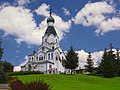 Orthodox church in the center of Medzilaborce


References
[edit]- ^ Statistical Office of the Slovak Republic (www.statistics.sk). "Hustota obyvateľstva - obce". www.statistics.sk. Retrieved 2024-02-08.
- ^ a b c d "Základná charakteristika". www.statistics.sk (in Slovak). Statistical Office of the Slovak Republic. 2015-04-17. Retrieved 2022-03-31.
- ^ Statistical Office of the Slovak Republic (www.statistics.sk). "Počet obyvateľov podľa pohlavia - obce (ročne)". www.statistics.sk. Retrieved 2024-02-08.
- ^ "Medzilaborce". Archived from the original on 2005-11-24. Retrieved 2007-10-01. (Slovak)
- ^ a b "Municipal Statistics". Statistical Office of the Slovak republic. Archived from the original on 2008-02-08. Retrieved 2008-02-17.
- ^ "Přátelství a spolupráce s městem Medzilaborce". namestnosl.cz (in Czech). Náměšť nad Oslavou. Retrieved 2019-09-05.
- ^ "Współpraca zagraniczna". kozienice.pl (in Polish). Kozienice. Retrieved 2019-09-05.
External links
[edit] Media related to Medzilaborce at Wikimedia Commons
- Official website

- Unofficial website of Medzilaborce (in Slovak)
- Medzilaborce: Modern art in a desolate town by Chris Togneri for the Spectacular Slovakia travel guide
- Catholic church of Byzantine rite in Medzilaborce
- The Andy Warhol Museum of Modern Art - city of origin
- Andy Warhol in Slovakia by Robert Rigney

Municipalities of Medzilaborce District | ||
|---|---|---|
| International | |
|---|---|
| National | |
| Other | |