
Grand Traverse Bay: Difference between revisions
Molandfreak (talk | contribs) |
m Cleaned up the footnote that I just added. |
||
| (47 intermediate revisions by 16 users not shown) | |||
| Line 1: | Line 1: | ||
{{short description|Arm of Lake Michigan in the Lower Peninsula of Michigan}} |
|||
{{About|the bay of Lake Michigan|similarly named bays|Traverse Bay (disambiguation){{!}}Traverse Bay}} |
|||
{{Use mdy dates|date=July 2017}} |
{{Use mdy dates|date=July 2017}} |
||
{{Infobox body of water |
{{Infobox body of water |
||
| name = Grand Traverse Bay |
| name = Grand Traverse Bay |
||
| native_name = |
| native_name = |
||
| native_name_lang = |
| native_name_lang = |
||
| image = Grand Traverse Bay from Elk Rapids.jpg |
| image = Grand Traverse Bay from Elk Rapids.jpg |
||
| image_size = 275 |
| image_size = 275 |
||
| alt = East Arm of Grand Traverse Bay |
| alt = East Arm of Grand Traverse Bay |
||
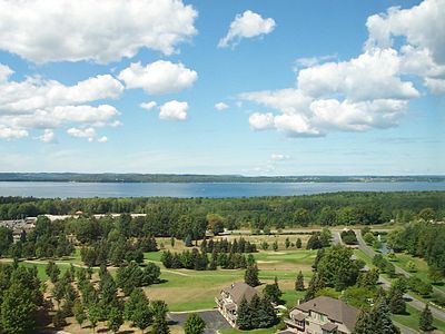
| caption = East Arm of Grand Traverse Bay looking west from [[Elk Rapids, Michigan|Elk Rapids]] toward [[Peninsula Township, Michigan|Old Mission Peninsula]] |
| caption = East Arm of Grand Traverse Bay looking west from [[Elk Rapids, Michigan|Elk Rapids]] toward [[Peninsula Township, Michigan|Old Mission Peninsula]] |
||
| pushpin_map = Michigan |
| pushpin_map = Michigan |
||
| pushpin_map_alt = |
| pushpin_map_alt = |
||
| pushpin_map_caption = Location within the state of Michigan |
| pushpin_map_caption = Location within the state of Michigan |
||
| pushpin_label = Grand Traverse |
| pushpin_label = Grand Traverse Bay |
||
| image_bathymetry = |
| image_bathymetry = |
||
| alt_bathymetry = |
| alt_bathymetry = |
||
| caption_bathymetry = |
| caption_bathymetry = |
||
| location = [[ |
| location = [[Antrim County, Michigan|Antrim]], [[Charlevoix County, Michigan|Charlevoix]], [[Grand Traverse County, Michigan|Grand Traverse]], and [[Leelanau County, Michigan|Leelanau]] counties, [[Michigan]], U.S. |
||
| coords = {{coord|45.06|N|85.48|W|scale:500000_region:US-MI_type:waterbody|display=inline,title}} |
| coords = {{coord|45.06|N|85.48|W|scale:500000_region:US-MI_type:waterbody|display=inline,title}} |
||
| type = [[Bay]]<ref name=gnis |
| type = [[Bay]]<ref name=gnis>{{GNIS|627115}}</ref> |
||
| inflow = [[Boardman River]], [[Elk River (Michigan)|Elk River]] |
| inflow = [[Boardman River]], [[Elk River (Michigan)|Elk River]] |
||
| rivers = |
| rivers = |
||
| outflow |
| outflow = |
||
| catchment = |
| catchment = |
||
| basin_countries = |
| basin_countries = |
||
| agency = |
| agency = |
||
| designation = |
| designation = |
||
| length = |
| length = |
||
| width = |
| width = |
||
| area = |
| area = |
||
| depth = |
| depth = |
||
| max-depth = |
| max-depth = |
||
| volume = |
| volume = |
||
| residence_time = |
| residence_time = |
||
| salinity = |
| salinity = |
||
| shore = |
| shore = |
||
| elevation = {{convert|581|ft}}<ref name=gnis /> |
| elevation = {{convert|581|ft}}<ref name=gnis /> |
||
| frozen = |
| frozen = |
||
| islands = [[Power Island]] |
| islands = [[Bellow Island]], [[Power Island]] |
||
| sections = |
| sections = |
||
| islands_category = |
| islands_category = |
||
| trenches = |
| trenches = |
||
| benches = |
| benches = |
||
| cities = [[Elk Rapids, Michigan|Elk Rapids]], [[Suttons Bay, Michigan|Suttons Bay]], [[Traverse City, Michigan|Traverse City]] |
|||
| cities = |
|||
| website = |
| website = |
||
| reference = |
| reference = |
||
| other_name = |
| other_name = |
||
| part_of |
| part_of = [[Lake Michigan]] |
||
}} |
}} |
||
'''Grand Traverse Bay''' is |
'''Grand Traverse Bay''' ({{IPAc-en|ˈ|t|r|æ|v|ər|s}} {{respell|TRAV|ərs}}) is an arm of [[Lake Michigan]], located along the west coast of the [[Lower Peninsula of Michigan|Lower Peninsula]] of [[Michigan]]. The bay is separated from the rest of Lake Michigan by the [[Leelanau Peninsula]]. The bay is some {{convert|32|mi|km}} long, ranges from {{Convert|7|to|10|mi|km|0}} wide, and up to {{convert|620|ft|m}} deep in spots. It is the second-largest bay of Lake Michigan, behind [[Green Bay (Lake Michigan)|Green Bay]]. |
||
Grand Traverse Bay is further divided into an East Arm and West Arm by the {{convert|18|mi|km|-long|adj=mid}} [[Old Mission Peninsula]].<ref>{{Cite web |date=2018-09-27 |title=Things to Do on Old Mission Peninsula: The Ultimate Pure Michigan Guide |url=https://www.michigan.org/article/trip-idea/things-to-do-old-mission-peninsula-ultimate-pure-michigan-guide |access-date=2024-07-09 |website=Pure Michigan {{!}} Official Travel & Tourism Website for Michigan |language=en}}</ref> At the head of both arms of the bay is [[Traverse City, Michigan|Traverse City]], the largest city in [[Northern Michigan]]. The area surrounding the bay is renowned for its fruit production, especially for [[Cherry production in Michigan|cherries]] and [[Michigan wine|viticulture]].<ref>{{Cite web |title=Fruit |url=https://project.geo.msu.edu/geogmich/fruit.html |access-date=2023-09-09 |website=project.geo.msu.edu}}</ref> |
|||
The bay is located within parts of the Michigan counties of [[Antrim County, Michigan|Antrim]], [[Charlevoix County, Michigan|Charlevoix]], [[Grand Traverse County, Michigan|Grand Traverse]], and [[Leelanau County, Michigan|Leelanau]]. |
|||
[[File:Grand Traverse Bay 432 pan crop 15 (32648536332).jpg|thumb|Close-up satellite view of the Grand Traverse Bay, oriented with north at the top. Note the East and West arms of the bay, divided by the Old Mission Peninsula.]] |
|||
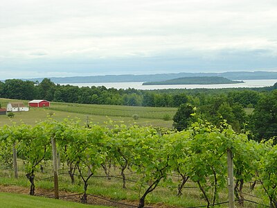
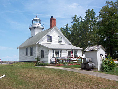
[[File:Grand Traverse Light.jpg|thumb|The [[Grand Traverse Light]]house at the tip of the [[Leelanau Peninsula]], which anchors the bay to the west.]][[File:MissionVineyard.jpg|thumb|[[Power Island]] is the largest island in the bay, seen here from [[Chateau Chantal]] on the [[Old Mission Peninsula]]]] |
|||
== Etymology == |
|||
Grand Traverse Bay earned its name from 18th-century French [[voyageurs]] who made ''{{lang|fr|la grande traverse}}'',{{refn|In modern standard French, ''{{lang|fr|traverse}}'' no longer has the sense of 'crossing'—which is now ''{{lang|fr|traversée}}''.<ref>{{cite web |url = http://cnrtl.fr/definition/traverse |title = traverse |publisher = Centre national de ressources textuelles |language = fr }}</ref>|group=lower-alpha}} or "the long crossing", across the mouth of bay. The area was owned by the French, followed by [[Kingdom of Great Britain|Great Britain]] as the [[Province of Quebec (1763–1791)|Province of Quebec]]. After 1776, the area was owned by the Americans.<ref>{{cite web |title=Grand Traverse Bay |url=http://www.michmarkers.com/pages/S0042.htm |access-date=October 28, 2010 |publisher=Michigan Historical Markers}}</ref> On Old Mission peninsula, Rev Peter Doughtery started the first permanent settlement in 1839. This was called "Grand Traverse",<ref>{{cite web |last=Norton |first=Mike |date=April 15, 2014 |title=Exploring the Past in Historic Traverse City |url=http://www.michigan.org/blog/guest-blogger/exploring-the-past-in-historic-traverse-city/}}</ref> but was later renamed to [[Old Mission, Michigan|Old Mission]]. |
|||
[[File:West Grand Traverse Bay, Traverse City, Michigan, USA 2014-07-12 17-56.jpg|thumb|West Grand Traverse Bay from Traverse City, facing Greilickville.]] |
|||
[[File:Inferior Mirage Grand Traverse Bay.jpg|thumb|An [[inferior mirage]] over the bay]] |
|||
== Geography == |
== Geography == |
||
[[Traverse City, Michigan|Traverse City]] is situated at the south end of the bay where the [[Boardman River]] empties into the west arm. Cherry orchards line the bay region, giving rise to Traverse City's claim to be the ''Cherry Capital of the World''. Several nationally known companies offer cherry-based products made with Northern Michigan tart cherries including Traverse Bay Farms, Cherry Central, Fruit Advantage, American Spoon, Cherry Republic and Old Mission Traders (formerly Cherry Stop). The region is the center of [[cherry production in Michigan]]. |
[[Traverse City, Michigan|Traverse City]] is situated at the south end of the bay where the [[Boardman River]] empties into the west arm. Cherry orchards line the bay region, giving rise to Traverse City's claim to be the ''Cherry Capital of the World''. Several nationally known companies offer cherry-based products made with Northern Michigan tart cherries including Traverse Bay Farms, Cherry Central, Fruit Advantage, American Spoon, Cherry Republic and Old Mission Traders (formerly Cherry Stop). The region is the center of [[cherry production in Michigan]]. |
||
The |
The most notable feature of the bay is that it is bisected into East<ref>{{GNIS|625111}}</ref> and West<ref>{{GNIS|1616011}}</ref> arms by the [[Peninsula Township, Michigan|Old Mission Peninsula]]. In addition, Grand Traverse is divided further into several important smaller bays, including Northport Bay, Suttons Bay, Omena Bay, Bowers Harbor, and Old Mission Bay. Northport Bay, located at the northwest corner of Grand Traverse Bay is about {{convert|10|mi|km|abbr=on}} long and {{convert|4|mi|km}} wide. Northport Bay open to the east, except inside the arms at each end, with the [[Leelanau Peninsula]] on the West side. There are several shoals in Northport Bay marked by buoys. [[Bellow Island]], a low gravel island covered by shrubs and located near the middle of Northport Bay, is owned by the [[Nature Conservancy]]; it is primarily known as a bird rookery, and is sometimes locally called ''Gull Island''. |
||
There are several marinas on the bay, including the large marinas in [[Northport, Michigan|Northport]], [[Greilickville, Michigan|Greilickville]], [[Traverse City, Michigan|Traverse City]], and [[Elk Rapids, Michigan|Elk Rapids]]. |
There are several marinas on the bay, including the large marinas in [[Northport, Michigan|Northport]], [[Greilickville, Michigan|Greilickville]], [[Traverse City, Michigan|Traverse City]], and [[Elk Rapids, Michigan|Elk Rapids]]. |
||
[[File:Grand Traverse Light.jpg|thumb|The [[Grand Traverse Light|Grand Traverse Lighthouse]] at the tip of the [[Leelanau Peninsula]], which anchors the bay to the west.]] |
|||
=== Communities === |
=== Communities === |
||
==== [[Antrim County, Michigan|Antrim County]] ==== |
|||
*[[Omena, Michigan|Omena]] |
|||
*[[Peshawbestown, Michigan|Peshawbestown]] |
|||
*[[Suttons Bay, Michigan|Suttons Bay]] |
|||
*[[Greilickville, Michigan|Greilickville]] |
|||
*[[Traverse City, Michigan|Traverse City]] |
|||
*[[Peninsula Township, Michigan|Bowers Harbor]] |
|||
*[[Neahtawanta]] |
|||
*[[Old Mission Point]] |
|||
*[[Peninsula Township, Michigan|Old Mission]] |
|||
*[[Peninsula Township, Michigan|Archie]] |
|||
*[[Acme Township, Michigan|Acme]] |
|||
*[[Yuba, Michigan|Yuba]] |
|||
*[[Elk Rapids, Michigan|Elk Rapids]] |
|||
*[[Antrim City, Michigan|Antrim City]] |
|||
*[[Norwood, Michigan|Norwood]] |
|||
* [[Antrim City, Michigan|Antrim City]] |
|||
[[File:Inferior Mirage Grand Traverse Bay.jpg|thumb|An [[inferior mirage]] over the bay]] |
|||
* [[Eastport, Michigan|Eastport]] |
|||
* [[Elk Rapids, Michigan|Elk Rapids]] |
|||
* [[Torch Lake, Michigan|Torch Lake]] |
|||
==== [[Charlevoix County, Michigan|Charlevoix County]] ==== |
|||
* [[Norwood, Michigan|Norwood]] |
|||
==== [[Grand Traverse County, Michigan|Grand Traverse County]] ==== |
|||
* [[Acme, Michigan|Acme]] |
|||
* [[Old Mission, Michigan|Old Mission]] |
|||
* [[Traverse City, Michigan|Traverse City]] |
|||
* [[Yuba, Michigan|Yuba]] |
|||
==== [[Leelanau County, Michigan|Leelanau County]] ==== |
|||
* [[Greilickville, Michigan|Greilickville]] |
|||
* [[Northport, Michigan|Northport]] |
|||
* [[Northport Point, Michigan|Northport Point]] |
|||
* [[Omena, Michigan|Omena]] |
|||
* [[Suttons Bay, Michigan|Suttons Bay]] |
|||
=== Arms and nested bays === |
|||
The Grand Traverse Bay is divided by the [[Old Mission Peninsula]] into two arms: |
|||
==== East Arm ==== |
|||
The East Arm of Grand Traverse Bay (colloquially known as "East Bay") is the deeper of the two arms. The arm is flanked to the west by the [[Old Mission Peninsula]], the south and southeast by mainland [[Grand Traverse County, Michigan|Grand Traverse County]], and to the east by southwestern [[Antrim County, Michigan|Antrim County]]. The arm's primary inflow is the [[Elk River (Michigan)|Elk River]], which drains the [[Elk River Chain of Lakes Watershed|Chain of Lakes]]. |
|||
==== West Arm ==== |
|||
The West Arm of Grand Traverse Bay (colloquially known as "West Bay") is the shallower and more urbanized of the two arms. The urban core of [[Traverse City, Michigan|Traverse City]] is located at the head of the West Arm. The arm is flanked to the west by the [[Leelanau Peninsula]], and to the east by the Old Mission Peninsula. Power Island is located within the West Arm. The primary inflow of the West Arm is the [[Boardman River]]. |
|||
==== Nested bays ==== |
|||
* Bowers Harbor<ref>{{Cite web |title=Geographic Names Information System |url=https://edits.nationalmap.gov/apps/gaz-domestic/public/search/names/a9386474-ba6c-5d78-8c20-bc036dd2267e/summary |access-date=2023-01-04 |website=edits.nationalmap.gov}}</ref> |
|||
* Ingalls Bay<ref>{{Cite web |title=Geographic Names Information System |url=https://edits.nationalmap.gov/apps/gaz-domestic/public/search/names/137e35da-40ce-5b84-ab01-76273c0f5218/summary |access-date=2023-01-04 |website=edits.nationalmap.gov}}</ref> |
|||
* Northport Bay<ref>{{Cite web |title=Geographic Names Information System |url=https://edits.nationalmap.gov/apps/gaz-domestic/public/search/names/2638b2ad-624e-5785-a520-26c8dd79c23d/summary |access-date=2023-01-04 |website=edits.nationalmap.gov}}</ref> |
|||
* Old Mission Harbor<ref>{{Cite web |title=Geographic Names Information System |url=https://edits.nationalmap.gov/apps/gaz-domestic/public/search/names/8c520915-2689-5032-859d-1f3452f90019/summary |access-date=2023-01-04 |website=edits.nationalmap.gov}}</ref> |
|||
* Omena Bay<ref>{{Cite web |title=Geographic Names Information System |url=https://edits.nationalmap.gov/apps/gaz-domestic/public/search/names/7697472f-b7fd-5776-b241-a154973ad7d5/summary |access-date=2023-01-04 |website=edits.nationalmap.gov}}</ref> |
|||
* Suttons Bay<ref>{{Cite web |title=Geographic Names Information System |url=https://edits.nationalmap.gov/apps/gaz-domestic/public/search/names/9794e199-e4ad-5af8-8f69-3c0b62f2a89a/summary |access-date=2023-01-04 |website=edits.nationalmap.gov}}</ref> |
|||
=== Islands === |
=== Islands === |
||
*Bassett Island |
|||
*[[Bellow Island]] |
|||
*[[Power Island]] |
|||
== Culture == |
|||
* Bellow Island (colloquially known as Gull Island) |
|||
Besides [[cherries]], the surrounding countryside produces [[grape]]s and is one of the centers of the [[Michigan wine]] industry. Known for its shimmering blue water and golden sand beaches, the Grand Traverse Bay region is a popular vacation destination. |
|||
* McAllister Island |
|||
* Helver Island |
|||
* Wilhelm Island |
|||
*[[Power Island]] (largest island in the bay, also known as Marion Island) |
|||
* Bassett Island |
|||
* Tucker Island |
|||
* Swaney Island |
|||
* Parallel Island (situated on the [[45th parallel north|45th Parallel]]) |
|||
* Esson Island |
|||
* Regal Island |
|||
* Blussy Island |
|||
* Norwood Point Island |
|||
In September 2007, [[Mark Holley]], an [[Underwater archaeology|underwater]] [[archeologist]] with the Grand Traverse Bay Underwater Preserve Council who teaches at [[Northwestern Michigan College]] in Traverse City, said that they might have discovered a boulder {{convert|3.5|to|4|ft|m}} high by {{convert|5|ft|m}} long) with a prehistoric carving in the Grand Traverse Bay.<ref>{{Cite web|title="Stonehenge" Lake Michigan by Dr. Mark Holley – Dr Mark Holley – Underwater Archaeologist|url=https://holleyarchaeology.com/wordpress/index.php/the-truth-about-the-stonehenge-in-lake-michigan/|access-date=2020-09-23|language=en-US}}</ref> The granite rock has markings that resemble a [[mastodon]] with a spear in its side. Confirmation that the markings are an ancient [[petroglyph]] will require more evidence.<ref>{{cite news |last=Flesher |first=John |title=Possible mastodon carving found on rock |publisher=Associated Press |date=2007-09-04 |url=https://news.yahoo.com/s/ap/20070904/ap_on_sc/mastodon_carving |access-date =2015-04-06 |archive-url = https://web.archive.org/web/20070904232125/http://news.yahoo.com/s/ap/20070904/ap_on_sc/mastodon_carving|archive-date = 2007-09-04}}</ref> The stone can be seen in a TV documentary,<ref>{{Cite web|title=Video of Underwater Lake Michigan – Dr Mark Holley – Underwater Archaeologist|url=https://holleyarchaeology.com/wordpress/index.php/underwater-videos/|access-date=2020-09-23|language=en-US}}</ref> and is pictured on page 9 of ''New Scientist Magazine'' of July 19, 2008. |
|||
== Etymology == |
|||
<gallery mode="packed" heights="200"> |
|||
Grand Traverse Bay earned its name from 18th-century French [[voyageurs]] who made ''{{lang|fr|la grande traverse}}'',{{refn|In modern standard French, ''{{lang|fr|traverse}}'' no longer has the sense of 'crossing'—which is now ''{{lang|fr|traversée}}''.<ref>{{cite web |url = http://cnrtl.fr/definition/traverse |title = traverse |publisher = Centre national de ressources textuelles |language = fr }}</ref>|group=lower-alpha}} or "the long crossing", across the mouth of bay. The area was owned by the French, followed by [[Kingdom of Great Britain|Great Britain]] as the [[Province of Quebec (1763–1791)|Province of Quebec]]. After 1776, the area was owned by the Americans.<ref>{{cite web|url=http://www.michmarkers.com/pages/S0042.htm|title=Grand Traverse Bay|date=|publisher=Michigan Historical Markers|access-date=October 28, 2010}}</ref> On Old Mission peninsula, Rev Peter Doughtery started the first permanent settlement in 1839. This was called "'''Grand Traverse'''"<ref>{{cite web|url=http://www.michigan.org/blog/guest-blogger/exploring-the-past-in-historic-traverse-city/|title=Exploring the Past in Historic Traverse City|last=Norton|first=Mike|date=April 15, 2014}}</ref>, but was later renamed to [[Old Mission, Michigan|Old Mission]]. |
|||
File:Grand Traverse Bay.jpg|The East Arm of Grand Traverse Bay from the east, with the [[Old Mission Peninsula]] in the background. Hills of the Leelanau Peninsula are faintly visible on the horizon. |
|||
File:Old Mission Peninsula.jpg|The West Arm of Grand Traverse Bay, seen from [[Chateau Chantal]] on the [[Old Mission Peninsula]]. |
|||
File:OldMission-MI-lighthouse.jpg|[[Mission Point Light|Mission Point Lighthouse]] sits at the end of the Old Mission Peninsula, which divides the bay into its East and West Arms. |
|||
</gallery> |
|||
== Shipwrecks == |
== Shipwrecks == |
||
<ref>{{Cite web |
[[File:TS State of Michigan on Grand Traverse Bay.jpg|thumb|[[TS State of Michigan]] at the [[Great Lakes Maritime Academy]] in Traverse City, on the shore of the bay]]The Grand Traverse Bay is home to the following shipwrecks:<ref>{{Cite web|title=Grand Traverse Bay Underwater Preserve|url=http://www.michiganpreserves.org/grandtraverse.htm|access-date=2019-02-24|website=www.michiganpreserves.org}}</ref> |
||
* |
*A.J. Rogers |
||
* Metropolis |
* Metropolis |
||
* Shale Scow |
* Shale Scow |
||
| Line 108: | Line 137: | ||
* Nyord |
* Nyord |
||
* Barge |
* Barge |
||
* Flora <ref>{{Cite web|title=George N. Fletcher Public Library|url=https://greatlakeships.org/2894360/data?n=9|access-date=2023-04-05|website=www.alpenalibrary.org}}</ref> |
|||
==Culture== |
|||
Besides [[cherries]], the surrounding countryside produces [[grape]]s and is one of the centers of the [[Michigan wine]] industry. Known for its shimmering blue water and golden sand beaches, the Grand Traverse Bay region is a popular vacation destination. |
|||
In September 2007, [[Mark Holley]], an [[Underwater archaeology|underwater]] [[archeologist]] with the Grand Traverse Bay Underwater Preserve Council who teaches at [[Northwestern Michigan College]] in Traverse City, said that they might have discovered a boulder {{convert|3.5|to|4|ft|m}} high x {{convert|5|ft|m}} long) with a prehistoric carving in the Grand Traverse Bay. The granite rock has markings that resemble a [[mastodon]] with a spear in its side. Confirmation that the markings are an ancient [[petroglyph]] will require more evidence.<ref>{{cite news |last=Flesher |first=John |title=Possible mastodon carving found on rock |publisher=Associated Press |date=2007-09-04 |url=https://news.yahoo.com/s/ap/20070904/ap_on_sc/mastodon_carving |accessdate =2015-04-06 |archiveurl = https://web.archive.org/web/20070904232125/http://news.yahoo.com/s/ap/20070904/ap_on_sc/mastodon_carving|archivedate = 2007-09-04}}</ref> The stone is pictured on page 9 of ''New Scientist Magazine'' of July 19, 2008. |
|||
<gallery mode="packed" heights="200px"> |
|||
File:Grand Traverse Bay.jpg|The East Arm of Grand Traverse Bay from the east, with the [[Old Mission Peninsula]] in the background. Hills of the Leelanau Peninsula are faintly visible on the horizon. |
|||
File:Old Mission Peninsula.jpg|The West Arm of Grand Traverse Bay, seen from [[Chateau Chantal]] on the [[Old Mission Peninsula]]. |
|||
</gallery> |
|||
== Notes == |
== Notes == |
||
| Line 134: | Line 155: | ||
*[http://www.gtbay.org/ Watershed Center Grand Traverse Bay] |
*[http://www.gtbay.org/ Watershed Center Grand Traverse Bay] |
||
*[http://www.schoolship.org/ Inland Seas Education Association] |
*[http://www.schoolship.org/ Inland Seas Education Association] |
||
*[https://greatlakeships.org/2894360/data?n=9/ George N Fletcher Public Library] |
|||
{{Protected areas of Michigan}} |
{{Protected areas of Michigan}} |
||
{{Northern Michigan}} |
{{Northern Michigan}} |
||
Revision as of 19:50, 9 July 2024
| Grand Traverse Bay | |
|---|---|
 East Arm of Grand Traverse Bay looking west from Elk Rapids toward Old Mission Peninsula | |
 Grand Traverse Bay Location within the state of Michigan | |
| Location | Antrim, Charlevoix, Grand Traverse, and Leelanau counties, Michigan, U.S. |
| Coordinates | 45°04′N 85°29′W / 45.06°N 85.48°W |
| Type | Bay[1] |
| Part of | Lake Michigan |
| Primary inflows | Boardman River, Elk River |
| Surface elevation | 581 feet (177 m)[1] |
| Islands | Bellow Island, Power Island |
| Settlements | Elk Rapids, Suttons Bay, Traverse City |
Grand Traverse Bay (/ˈtrævərs/ TRAV-ərs) is an arm of Lake Michigan, located along the west coast of the Lower Peninsula of Michigan. The bay is separated from the rest of Lake Michigan by the Leelanau Peninsula. The bay is some 32 miles (51 km) long, ranges from 7 to 10 miles (11 to 16 km) wide, and up to 620 feet (190 m) deep in spots. It is the second-largest bay of Lake Michigan, behind Green Bay.
Grand Traverse Bay is further divided into an East Arm and West Arm by the 18-mile-long (29 km) Old Mission Peninsula.[2] At the head of both arms of the bay is Traverse City, the largest city in Northern Michigan. The area surrounding the bay is renowned for its fruit production, especially for cherries and viticulture.[3]
The bay is located within parts of the Michigan counties of Antrim, Charlevoix, Grand Traverse, and Leelanau.
.jpg)


Etymology
Grand Traverse Bay earned its name from 18th-century French voyageurs who made la grande traverse,[a] or "the long crossing", across the mouth of bay. The area was owned by the French, followed by Great Britain as the Province of Quebec. After 1776, the area was owned by the Americans.[5] On Old Mission peninsula, Rev Peter Doughtery started the first permanent settlement in 1839. This was called "Grand Traverse",[6] but was later renamed to Old Mission.


Geography
Traverse City is situated at the south end of the bay where the Boardman River empties into the west arm. Cherry orchards line the bay region, giving rise to Traverse City's claim to be the Cherry Capital of the World. Several nationally known companies offer cherry-based products made with Northern Michigan tart cherries including Traverse Bay Farms, Cherry Central, Fruit Advantage, American Spoon, Cherry Republic and Old Mission Traders (formerly Cherry Stop). The region is the center of cherry production in Michigan.
The most notable feature of the bay is that it is bisected into East[7] and West[8] arms by the Old Mission Peninsula. In addition, Grand Traverse is divided further into several important smaller bays, including Northport Bay, Suttons Bay, Omena Bay, Bowers Harbor, and Old Mission Bay. Northport Bay, located at the northwest corner of Grand Traverse Bay is about 10 mi (16 km) long and 4 miles (6.4 km) wide. Northport Bay open to the east, except inside the arms at each end, with the Leelanau Peninsula on the West side. There are several shoals in Northport Bay marked by buoys. Bellow Island, a low gravel island covered by shrubs and located near the middle of Northport Bay, is owned by the Nature Conservancy; it is primarily known as a bird rookery, and is sometimes locally called Gull Island.
There are several marinas on the bay, including the large marinas in Northport, Greilickville, Traverse City, and Elk Rapids.
Communities
Arms and nested bays
The Grand Traverse Bay is divided by the Old Mission Peninsula into two arms:
East Arm
The East Arm of Grand Traverse Bay (colloquially known as "East Bay") is the deeper of the two arms. The arm is flanked to the west by the Old Mission Peninsula, the south and southeast by mainland Grand Traverse County, and to the east by southwestern Antrim County. The arm's primary inflow is the Elk River, which drains the Chain of Lakes.
West Arm
The West Arm of Grand Traverse Bay (colloquially known as "West Bay") is the shallower and more urbanized of the two arms. The urban core of Traverse City is located at the head of the West Arm. The arm is flanked to the west by the Leelanau Peninsula, and to the east by the Old Mission Peninsula. Power Island is located within the West Arm. The primary inflow of the West Arm is the Boardman River.
Nested bays
- Bowers Harbor[9]
- Ingalls Bay[10]
- Northport Bay[11]
- Old Mission Harbor[12]
- Omena Bay[13]
- Suttons Bay[14]
Islands
- Bassett Island
- Bellow Island
- Power Island
Culture
Besides cherries, the surrounding countryside produces grapes and is one of the centers of the Michigan wine industry. Known for its shimmering blue water and golden sand beaches, the Grand Traverse Bay region is a popular vacation destination.
In September 2007, Mark Holley, an underwater archeologist with the Grand Traverse Bay Underwater Preserve Council who teaches at Northwestern Michigan College in Traverse City, said that they might have discovered a boulder 3.5 to 4 feet (1.1 to 1.2 m) high by 5 feet (1.5 m) long) with a prehistoric carving in the Grand Traverse Bay.[15] The granite rock has markings that resemble a mastodon with a spear in its side. Confirmation that the markings are an ancient petroglyph will require more evidence.[16] The stone can be seen in a TV documentary,[17] and is pictured on page 9 of New Scientist Magazine of July 19, 2008.
-
 The East Arm of Grand Traverse Bay from the east, with the Old Mission Peninsula in the background. Hills of the Leelanau Peninsula are faintly visible on the horizon.
 -
 The West Arm of Grand Traverse Bay, seen from Chateau Chantal on the Old Mission Peninsula.
 -
 Mission Point Lighthouse sits at the end of the Old Mission Peninsula, which divides the bay into its East and West Arms.


Shipwrecks

The Grand Traverse Bay is home to the following shipwrecks:[18]
- A.J. Rogers
- Metropolis
- Shale Scow
- Yuba Wreck
- Tramp
- Elmwood
- Nyord
- Barge
- Flora [19]
Notes
References
- ^ a b U.S. Geological Survey Geographic Names Information System: Grand Traverse Bay
- ^ "Things to Do on Old Mission Peninsula: The Ultimate Pure Michigan Guide". Pure Michigan | Official Travel & Tourism Website for Michigan. September 27, 2018. Retrieved July 9, 2024.
- ^ "Fruit". project.geo.msu.edu. Retrieved September 9, 2023.
- ^ "traverse" (in French). Centre national de ressources textuelles.
- ^ "Grand Traverse Bay". Michigan Historical Markers. Retrieved October 28, 2010.
- ^ Norton, Mike (April 15, 2014). "Exploring the Past in Historic Traverse City".
- ^ U.S. Geological Survey Geographic Names Information System: Grand Traverse Bay
- ^ U.S. Geological Survey Geographic Names Information System: Grand Traverse Bay
- ^ "Geographic Names Information System". edits.nationalmap.gov. Retrieved January 4, 2023.
- ^ "Geographic Names Information System". edits.nationalmap.gov. Retrieved January 4, 2023.
- ^ "Geographic Names Information System". edits.nationalmap.gov. Retrieved January 4, 2023.
- ^ "Geographic Names Information System". edits.nationalmap.gov. Retrieved January 4, 2023.
- ^ "Geographic Names Information System". edits.nationalmap.gov. Retrieved January 4, 2023.
- ^ "Geographic Names Information System". edits.nationalmap.gov. Retrieved January 4, 2023.
- ^ ""Stonehenge" Lake Michigan by Dr. Mark Holley – Dr Mark Holley – Underwater Archaeologist". Retrieved September 23, 2020.
- ^ Flesher, John (September 4, 2007). "Possible mastodon carving found on rock". Associated Press. Archived from the original on September 4, 2007. Retrieved April 6, 2015.
- ^ "Video of Underwater Lake Michigan – Dr Mark Holley – Underwater Archaeologist". Retrieved September 23, 2020.
- ^ "Grand Traverse Bay Underwater Preserve". www.michiganpreserves.org. Retrieved February 24, 2019.
- ^ "George N. Fletcher Public Library". www.alpenalibrary.org. Retrieved April 5, 2023.
External links
- Michigan Wines Website
- Wineries of Old Mission
- Leelanau Peninsula Wine Trail
- Southwest Michigan Wine Trail
- List of cherry farms located in the Traverse Bay Region
- Underwater photographs of Grand Traverse Bay's West arm
- Watershed Center Grand Traverse Bay
- Inland Seas Education Association
- George N Fletcher Public Library
| Central cities | |
|---|---|
| Counties | |
| Geography | |
| Transportation | |
| Economy | |
Great Lakes of North America | |||||||||||||
|---|---|---|---|---|---|---|---|---|---|---|---|---|---|
| Main lakes | |||||||||||||
| Secondary lakes | |||||||||||||
| Bays and channels |
| ||||||||||||
| Waterways | |||||||||||||
| Islands | |||||||||||||
| Historic geology | |||||||||||||
| Organizations |
| ||||||||||||
| Related topics |
| ||||||||||||
| International | |
|---|---|
| National | |
| Other | |