
Arda (Maritsa tributary): Difference between revisions
No edit summary |
Updated short description Tags: Mobile edit Mobile app edit Android app edit |
||
| (12 intermediate revisions by 11 users not shown) | |||
| Line 1: | Line 1: | ||
{{Short description|River in Bulgaria, Greece and Turkey}} |
|||
{{Unreferenced|date=December 2009}} |
|||
{{Infobox river |
{{Infobox river |
||
| name = Arda (Арда), Ardas (Άρδας) |
| name = Arda (Арда), Ardas (Άρδας) |
||
| image = Меандър на река Арда.jpg |
| image = Меандър на река Арда.jpg |
||
| image_caption = The Arda at Valchi dol, [[Bulgaria]] |
| image_caption = The Arda at Valchi dol, [[Bulgaria]] |
||
| source1 = [[Rhodope Mountains]] |
|||
| source1_location = near [[Smolyan]], [[Rhodopes]], Bulgaria |
|||
| |
| source1_location = [[Smolyan]], [[Rhodopes]], Bulgaria |
||
| |
| source1_coordinates = {{Coord|41.431|24.610|format=dms|display=i}} |
||
| ⚫ | |||
| length = {{convert|290|km|mi|abbr=on}}; {{convert|241|km|mi|abbr=on}} in Bulgaria) |
|||
| source1_elevation = {{convert|1455|m|ft|abbr=on}} (Ardin vrah) |
| source1_elevation = {{convert|1455|m|ft|abbr=on}} (Ardin vrah) |
||
| mouth = [[Maritsa]] |
|||
| mouth_location = [[Edirne]], Turkey |
|||
| mouth_coordinates = {{coord|41|39|39|N|26|29|42|E|display=inline,title}} |
|||
| mouth_elevation = {{convert|33|m|abbr=on}} |
|||
| progression = {{RMaritsa}} |
|||
| subdivision_type1 = Countries |
|||
| ⚫ | |||
| length = {{convert|290|km|mi|abbr=on}}; {{convert|229|km|mi|abbr=on}} in Bulgaria<ref name=Yearbook>[http://www.nsi.bg/sites/default/files/files/publications/God2017.pdf Statistical Yearbook 2017], [[National Statistical Institute (Bulgaria)]], p. 17</ref> |
|||
| discharge1_avg = |
| discharge1_avg = |
||
| basin_size = {{convert|5795|km2|mi2|abbr=on}} |
| basin_size = {{convert|5795|km2|mi2|abbr=on}}; {{convert|5213|km2|abbr=on}} in Bulgaria<ref name=Yearbook/> |
||
| map =Arda Mariza.jpg |
| map =Arda Mariza.jpg |
||
| map_caption =Map of Arda River and [[Maritsa|Maritsa river]] |
| map_caption =Map of Arda River and [[Maritsa|Maritsa river]] |
||
}} |
}} |
||
The '''Arda''' ({{Lang-bg|Арда | |
The '''Arda''' ({{Lang-bg|Арда}} {{IPA-bg|ˈardɐ|}}, {{Lang-el|Άρδας}} {{IPA-el|ˈarðas|}}, {{Lang-tr|Arda}} {{IPA-tr|ˈaɾda|}}) is a {{convert|290|km|mi|adj=mid|-long}} river in [[Bulgaria]] and [[Greece]]. It is a tributary of the [[Maritsa]] (or Evros). Its source lies in the Bulgarian [[Rhodope Mountains]] near the village [[Arda, Bulgaria|Arda]], part of the municipality of [[Smolyan]]. It flows eastward past [[Rudozem]], [[Kardzhali]] and [[Ivaylovgrad]] and enters Greece in the northern part of the [[Evros (regional unit)|Evros regional unit]]. It flows into the Maritsa on the border of Greece and [[Turkey]], between the Greek village [[Kastanies]] and the Turkish city [[Edirne]]. In the Bulgarian section, there are three [[hydroelectric]] and [[irrigation]] [[dam]]s, [[Kardzhali Dam]], [[Studen Kladenets]] and [[Ivaylovgrad Dam]]. The Bulgarian section is {{convert|229|km|mi}} long,<ref name=Yearbook/> making the Arda the longest river in the [[Rhodopes]]. The medieval [[Dyavolski most (bridge)|Dyavolski most]] arch bridge crosses the river {{convert|10|km|mi|0}} from [[Ardino]]. |
||
The three floods of February 18, 2005, when the water level was at {{convert|4.8|m|ft}}, March 1 and March 7, 2005, flooded the low-lying areas, especially |
The three floods of February 18, 2005, when the water level was at {{convert|4.8|m|ft}}, March 1 and March 7, 2005, flooded the low-lying areas, especially the Kastanies area which turned into a lagoon. The merging of the waters of the Maritsa (Evros/Meriç) caused streets and buildings including homes to be flooded, leaving people stranded in their homes. |
||
[[Arda Peak]] on [[Livingston Island]] in the [[South Shetland Islands]], [[Antarctica]] and the mineral [[ardaite]] are named after the Arda river. |
[[Arda Peak]] on [[Livingston Island]] in the [[South Shetland Islands]], [[Antarctica]] and the mineral [[ardaite]] are named after the Arda river. |
||
==Archeology and places of interest== |
|||
The Arda valley and the valleys of its tributaries have been a preferred place for habitation since ancient times. A settlement from 6,000 BC was discovered during the construction works in the area of the town of Kardzhali. Many archeological sites were discovered in the region, including the famous Thracian cult complexes Perperek, known as [[Perperikon]] for the last 20 years, as well as the sacred site of Tatul. To cross the ancient roads to the [[Aegean Sea|Aegean]], several stone bridges were built on the river, impressive in size and architecture. One fully preserved bridge is the Devil's Bridge in the area of the village of Dyadovtsi (Ardino municipality). There are remnants of bridges in several places in the region: near the villages of Suhovo and Borovitsa, and another three have remained under the waters of the dams. |
|||
==Gallery== |
==Gallery== |
||
| Line 34: | Line 43: | ||
==References== |
==References== |
||
{{Reflist}} |
{{Reflist}} |
||
{{Authority control}} |
|||
[[Category:Rivers of Bulgaria]] |
[[Category:Rivers of Bulgaria]] |
||
Latest revision as of 07:32, 13 July 2024
| Arda (Арда), Ardas (Άρδας) | |
|---|---|
 The Arda at Valchi dol, Bulgaria | |
 Map of Arda River and Maritsa river | |
| Location | |
| Countries | Bulgaria, Greece, and Turkey |
| Physical characteristics | |
| Source | Rhodope Mountains |
| • location | Smolyan, Rhodopes, Bulgaria |
| • coordinates | 41°25′52″N 24°36′36″E / 41.431°N 24.610°E |
| • elevation | 1,455 m (4,774 ft) (Ardin vrah) |
| Mouth | Maritsa |
• location | Edirne, Turkey |
• coordinates | 41°39′39″N 26°29′42″E / 41.66083°N 26.49500°E |
• elevation | 33 m (108 ft) |
| Length | 290 km (180 mi); 229 km (142 mi) in Bulgaria[1] |
| Basin size | 5,795 km2 (2,237 sq mi); 5,213 km2 (2,013 sq mi) in Bulgaria[1] |
| Basin features | |
| Progression | Maritsa→ Aegean Sea |
The Arda (Bulgarian: Арда [ˈardɐ], Greek: Άρδας [ˈarðas], Turkish: Arda [ˈaɾda]) is a 290-kilometre-long (180 mi) river in Bulgaria and Greece. It is a tributary of the Maritsa (or Evros). Its source lies in the Bulgarian Rhodope Mountains near the village Arda, part of the municipality of Smolyan. It flows eastward past Rudozem, Kardzhali and Ivaylovgrad and enters Greece in the northern part of the Evros regional unit. It flows into the Maritsa on the border of Greece and Turkey, between the Greek village Kastanies and the Turkish city Edirne. In the Bulgarian section, there are three hydroelectric and irrigation dams, Kardzhali Dam, Studen Kladenets and Ivaylovgrad Dam. The Bulgarian section is 229 kilometres (142 mi) long,[1] making the Arda the longest river in the Rhodopes. The medieval Dyavolski most arch bridge crosses the river 10 kilometres (6 mi) from Ardino.
The three floods of February 18, 2005, when the water level was at 4.8 metres (16 ft), March 1 and March 7, 2005, flooded the low-lying areas, especially the Kastanies area which turned into a lagoon. The merging of the waters of the Maritsa (Evros/Meriç) caused streets and buildings including homes to be flooded, leaving people stranded in their homes.
Arda Peak on Livingston Island in the South Shetland Islands, Antarctica and the mineral ardaite are named after the Arda river.
Archeology and places of interest
[edit]The Arda valley and the valleys of its tributaries have been a preferred place for habitation since ancient times. A settlement from 6,000 BC was discovered during the construction works in the area of the town of Kardzhali. Many archeological sites were discovered in the region, including the famous Thracian cult complexes Perperek, known as Perperikon for the last 20 years, as well as the sacred site of Tatul. To cross the ancient roads to the Aegean, several stone bridges were built on the river, impressive in size and architecture. One fully preserved bridge is the Devil's Bridge in the area of the village of Dyadovtsi (Ardino municipality). There are remnants of bridges in several places in the region: near the villages of Suhovo and Borovitsa, and another three have remained under the waters of the dams.
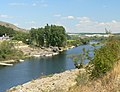
Gallery
[edit]-
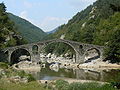 Devil's bridge near Ardino
 -
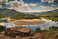 Arda's Meander in Bulgaria
 -
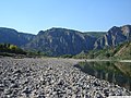 Near Madzharovo
 -
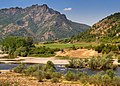 Near Madzharovo
 -


References
[edit]| International | |
|---|---|
| National | |
.svg) | This Eastern Macedonia and Thrace location article is a stub. You can help Wikipedia by expanding it. |
This article related to a river in Greece is a stub. You can help Wikipedia by expanding it. |
This article about a Marmara Region of Turkey location is a stub. You can help Wikipedia by expanding it. |
This article related to a river in Turkey is a stub. You can help Wikipedia by expanding it. |
- Tributaries of the Maritsa
- Rivers of Bulgaria
- Rivers of Greece
- Rivers of Turkey
- Rhodope Mountains
- International rivers of Europe
- Landforms of Edirne Province
- Landforms of Smolyan Province
- Landforms of Kardzhali Province
- Landforms of Haskovo Province
- Landforms of Evros (regional unit)
- Rivers of Eastern Macedonia and Thrace
- Europe river stubs
- Bulgaria geography stubs
- Eastern Macedonia and Thrace geography stubs
- Greece river stubs
- Marmara Region geography stubs
- Turkey river stubs