
Unter den Linden: Difference between revisions
Undid revision 1118204575 by 75.144.220.81 (talk) not relevant |
updated |
||
| (23 intermediate revisions by 15 users not shown) | |||
| Line 1: | Line 1: | ||
{{short description| |
{{short description|Thoroughfare in Berlin, Germany}} |
||
{{other uses|Unter den Linden (Berlin U-Bahn)|Unter den Linden (waltz)}} |
{{other uses|Unter den Linden (Berlin U-Bahn)|Unter den Linden (waltz)}} |
||
{{distinguish|text=the poem [[Under der linden]]}} |
{{distinguish|text=the poem [[Under der linden]]}} |
||
[[File:Unter den Linden von oben cropped.jpg|thumb|320px|Unter den Linden from [[Berlin Cathedral]] to [[Brandenburg Gate]] and [[Tiergarten (park)|Tiergarten]] park, view from [[Fernsehturm Berlin|Fernsehturm]], 2005]] |
[[File:Unter den Linden von oben cropped.jpg|thumb|320px|Unter den Linden from [[Berlin Cathedral]] to [[Brandenburg Gate]] and [[Tiergarten (park)|Tiergarten]] park, view from [[Fernsehturm Berlin|Fernsehturm]], 2005]] |
||
'''Unter den Linden''' ({{IPA-de|ˈʊntɐ deːn ˈlɪndn̩|lang}}, "under the [[Tilia|linden]] trees") is a [[boulevard]] in the central [[Mitte (locality)|Mitte]] district of [[Berlin]], |
'''Unter den Linden''' ({{IPA-de|ˈʊntɐ deːn ˈlɪndn̩|lang|De-Unter den Linden.ogg}}, "under the [[Tilia|linden]] trees") is a [[boulevard]] in the central [[Mitte (locality)|Mitte]] district of [[Berlin]], Germany. Running from the [[Berlin Palace]] to the [[Brandenburg Gate]], it is named after the [[Tilia|linden trees]] (known as lime in the UK and Ireland, not related to citrus lime) that line the grassed pedestrian mall on the median and the two broad [[carriageway]]s. The avenue links numerous Berlin [[List of tourist attractions in Berlin|sights]], landmarks and rivers for sightseeing. |
||
==Overview== |
==Overview== |
||
[[File:Lindenallee Berlin 1691.jpg|thumb|left|J. Stridbeck, ''LindenAllee 1691'']] |
[[File:Lindenallee Berlin 1691.jpg|thumb|left|J. Stridbeck, ''LindenAllee 1691'']] |
||
Unter den Linden runs east–west from the |
Unter den Linden runs east–west from the [[Berlin Palace]], the former main residence of the royal [[House of Hohenzollern]], reconstructed (after the demolition of the communist [[Palace of the Republic (Berlin)|Palace of the Republic]]) on its old site opposite the [[Lustgarten]] park, to [[Pariser Platz]] and [[Brandenburg Gate]]. Major north–south streets crossing ''Unter den Linden'' are [[Friedrichstraße]] and [[Wilhelmstrasse]], both meeting at [[Mehringplatz]] and running across the [[Friedrichstadt (Berlin)|Friedrichstadt]], a city expansion founded in 1691. |
||
Eastward the boulevard crosses the [[Spree (river)|Spree]] river, slightly kinked due to the oblique position of the long side of the palace compared to the boulevard, at the Lustgarten with [[Berlin Cathedral]], and continues as [[Karl-Liebknecht-Straße]], itself continued as [[Prenzlauer Allee]], to the northern outskirts. The western, dead straight continuation behind Brandenburg Gate is the [[Straße des 17. Juni]] (formerly ''Charlottenburger Chaussee''), which in turn is extended to the west by the straight sequence of Bismarckstrasse and [[Kaiserdamm]], an axis, widened in 1904, that runs from Berlin Palace more than 10 kilometers across the city to the western outskirts where, slightly elevated, one can survey the length of the axis. The extension of the ''Linden'' alley to this gigantic axis was inspired by the [[Boulevards of Paris]]. The [[Kurfürstendamm]], the magnificent shopping mile in the historically elegant west of Berlin, was similarly inspired. |
|||
Unter den Linden, which sits at the heart of the historic section of Berlin, developed from a bridle path laid out by Elector [[John George, Elector of Brandenburg|John George of Brandenburg]] in the 16th century to reach his hunting grounds in the [[Tiergarten (Berlin)|Tiergarten]]. It was replaced by a boulevard of linden trees around present-day [[Bebelplatz]] was integrated into the fortification of Berlin in the aftermath of the [[Thirty Years' War]], visible until today as there are no trees. |
|||
[[File:Franz Krüger Parade auf dem Opernplatz Berlin.jpg|thumb|''Parade on Opernplatz'' (by [[Franz Krüger]], between 1824 and 1830). In the very background the planting with the linden trees begins towards the Brandenburg Gate.]] |
|||
Unter den Linden, which sits at the heart of the historic section of Berlin, developed from a bridle path laid out by Elector [[John George, Elector of Brandenburg|John George of Brandenburg]] in the 16th century to reach his hunting grounds in the [[Tiergarten (Berlin)|Tiergarten]] from his palace. It was replaced by a boulevard of linden trees when the Electress [[Princess Dorothea Sophie of Schleswig-Holstein-Sonderburg-Glücksburg|Dorothea Sophie]] planned a new suburb in 1674, named after her [[Dorotheenstadt]]. She is said to have planted the first linden tree in 1680. Parts of the fortification of Berlin built in the aftermath of the [[Thirty Years' War]] (the baroque [[Berlin Fortress]]) were later integrated into the boulevard, around the historic ''Opernplatz'', the present-day [[Bebelplatz]], visible until today as there are no trees on this stretch up to the palace on the Spree river island itself. Bebelplatz itself was planned by [[Frederick the Great]] as a much larger ''Forum Fridericianum'', albeit on a smaller scale actually realized with his [[Berlin State Opera|State Opera]], [[St. Hedwig's Cathedral]], the ''Old Library Building'' and the ''Palace of [[Prince Henry of Prussia (1726–1802)|Prince Henry]]'', today the main building of [[Humboldt University of Berlin|Humboldt University]], giving the square an almost complete surround of 18th-century buildings. |
|||
| ⚫ | |||
By the 19th century, as Berlin grew and expanded to the west, Unter den Linden became the most renowned and grandest street in Berlin. In 1851 the famous [[equestrian statue of Frederick the Great]], designed by [[Christian Daniel Rauch]], was erected on the central strip. [[Johann Strauss III]] wrote the waltz "''[[Unter den Linden (waltz)|Unter den Linden]]''" in 1900. In the course of the building of the [[Berlin Nord-Süd-Tunnel|Nord-Süd-Tunnel]] for the [[Berlin S-Bahn]] in 1934–35, most of the linden trees were cut down and during the last days of [[World War II]] the remaining trees were destroyed or cut down for firewood. The present-day linden were replanted in the 1950s. |
By the 19th century, as Berlin grew and expanded to the west, Unter den Linden became the most renowned and grandest street in Berlin. In 1851 the famous [[equestrian statue of Frederick the Great]], designed by [[Christian Daniel Rauch]], was erected on the central strip. [[Johann Strauss III]] wrote the waltz "''[[Unter den Linden (waltz)|Unter den Linden]]''" in 1900. In the course of the building of the [[Berlin Nord-Süd-Tunnel|Nord-Süd-Tunnel]] for the [[Berlin S-Bahn]] in 1934–35, most of the linden trees were cut down and during the last days of [[World War II]] the remaining trees were destroyed or cut down for firewood. The present-day linden were replanted in the 1950s. |
||
| ⚫ | |||
As the location of the pre-1914 German Foreign Ministry building, "the Under den Linden" was sometimes used as a shorthand for the German government when talking of German foreign policy. |
|||
==Points of interest== |
==Points of interest== |
||
[[File:Map of Unter den Linden, Berlin.gif|right|400px|Map showing the main points of interest]] |
[[File:Map of Unter den Linden, Berlin.gif|right|400px|Map showing the main points of interest]] |
||
Since 1937, the numbering of the properties on the street has started at the ''Schlossbrücke'' (Palace Bridge), which connects Unter den Linden with the Lustgarten and [[Museum Island]]. The reconstructed [[Alte Kommandantur]] is at No. 1, standing opposite the [[Zeughaus]] arsenal, the oldest building on Unter den Linden, built between 1695 and 1706, now the seat of the ''[[Deutsches Historisches Museum]]'', No. 2. Buildings along the street include (from east to west) the [[Kronprinzenpalais|Crown Prince's Palace]] (the former palace of the [[House of Hohenzollern|Hohenzollern]] crown princes), at No. 3, opposite the [[Neue Wache]] war memorial, No. 4, [[Karl Friedrich Schinkel]]’s masterpiece built in 1817. Further along, on [[Bebelplatz]], the [[Berlin State Opera]], No. 7, colloquially called ''Lindenoper'', [[St. Hedwig's Cathedral]] and the ''Altes Palais'', No. 9, ([[Old Palace, Berlin]]) a |
Since 1937, the numbering of the properties on the street has started at the ''Schlossbrücke'' (Palace Bridge), which connects Unter den Linden with the Lustgarten and [[Museum Island]]. The reconstructed [[Alte Kommandantur]] is at No. 1, standing opposite the [[Zeughaus]] arsenal, the oldest building on Unter den Linden, built between 1695 and 1706, now the seat of the ''[[Deutsches Historisches Museum]]'', No. 2. Buildings along the street include (from east to west) the [[Kronprinzenpalais|Crown Prince's Palace]] (the former palace of the [[House of Hohenzollern|Hohenzollern]] crown princes), at No. 3, opposite the [[Neue Wache]] war memorial, No. 4, [[Karl Friedrich Schinkel]]’s masterpiece built in 1817. Further along, on [[Bebelplatz]], the [[Berlin State Opera]], No. 7, colloquially called ''Lindenoper'', [[St. Hedwig's Cathedral]] and the ''Altes Palais'', No. 9, ([[Old Palace, Berlin]]) a favourite [[Neoclassical architecture|Neoclassical]] residence of [[Wilhelm I, German Emperor|Emperor Wilhelm I]]; next, on the north side lies the main building of the [[Humboldt University of Berlin|Humboldt University]], No. 6, and House I of the [[Berlin State Library]], No. 8. At the western end are the [[Embassy of Russia in Berlin|Russian Embassy]] (former Soviet Embassy, Nos. 63-65, the [[Hungary|Hungarian]] Embassy, No. 76, standing at the junction with Wilhelmstrasse, and finally the [[Hotel Adlon]], No. 77, at the corner of Pariser Platz, which has been completely rebuilt on the site of the pre-war hotel. Well-known statues of [[Alexander von Humboldt|Alexander]] and [[Wilhelm von Humboldt]] in front of the university as well as of the [[Kingdom of Prussia|Prussian]] generals [[Gerhard von Scharnhorst|Scharnhorst]] and [[Friedrich Wilhelm Freiherr von Bülow|Bülow]], also adorn the street. |
||
A street sign carrying the name Unter den Linden dating from before the 1930s was taken away by British forces and can now be seen at the [[Imperial War Museum]], London. |
A street sign carrying the name Unter den Linden dating from before the 1930s was taken away by British forces and can now be seen at the [[Imperial War Museum]], London. |
||
{{clear|both}} |
{{clear|both}} |
||
| Line 35: | Line 43: | ||
File:2005-10-26 Brandenburger-Tor.JPG|[[Brandenburg Gate]] at [[Pariser Platz]], which marks the western terminus |
File:2005-10-26 Brandenburger-Tor.JPG|[[Brandenburg Gate]] at [[Pariser Platz]], which marks the western terminus |
||
File:Berlin Bebelplatz asv2018-05 img3.jpg|[[Bebelplatz]] |
File:Berlin Bebelplatz asv2018-05 img3.jpg|[[Bebelplatz]] |
||
File: |
File:Berlin-BerlinerSchloss-6-Asio.JPG|The reconstructed [[Berlin Palace]] |
||
</gallery> |
</gallery> |
||
| Line 49: | Line 57: | ||
{{Visitor attractions in Berlin}} |
{{Visitor attractions in Berlin}} |
||
{{Authority control}} |
{{Authority control}} |
||
Revision as of 00:31, 5 August 2024

Unter den Linden (German: [ˈʊntɐ deːn ˈlɪndn̩] , "under the linden trees") is a boulevard in the central Mitte district of Berlin, Germany. Running from the Berlin Palace to the Brandenburg Gate, it is named after the linden trees (known as lime in the UK and Ireland, not related to citrus lime) that line the grassed pedestrian mall on the median and the two broad carriageways. The avenue links numerous Berlin sights, landmarks and rivers for sightseeing.
Overview

Unter den Linden runs east–west from the Berlin Palace, the former main residence of the royal House of Hohenzollern, reconstructed (after the demolition of the communist Palace of the Republic) on its old site opposite the Lustgarten park, to Pariser Platz and Brandenburg Gate. Major north–south streets crossing Unter den Linden are Friedrichstraße and Wilhelmstrasse, both meeting at Mehringplatz and running across the Friedrichstadt, a city expansion founded in 1691.
Eastward the boulevard crosses the Spree river, slightly kinked due to the oblique position of the long side of the palace compared to the boulevard, at the Lustgarten with Berlin Cathedral, and continues as Karl-Liebknecht-Straße, itself continued as Prenzlauer Allee, to the northern outskirts. The western, dead straight continuation behind Brandenburg Gate is the Straße des 17. Juni (formerly Charlottenburger Chaussee), which in turn is extended to the west by the straight sequence of Bismarckstrasse and Kaiserdamm, an axis, widened in 1904, that runs from Berlin Palace more than 10 kilometers across the city to the western outskirts where, slightly elevated, one can survey the length of the axis. The extension of the Linden alley to this gigantic axis was inspired by the Boulevards of Paris. The Kurfürstendamm, the magnificent shopping mile in the historically elegant west of Berlin, was similarly inspired.

Unter den Linden, which sits at the heart of the historic section of Berlin, developed from a bridle path laid out by Elector John George of Brandenburg in the 16th century to reach his hunting grounds in the Tiergarten from his palace. It was replaced by a boulevard of linden trees when the Electress Dorothea Sophie planned a new suburb in 1674, named after her Dorotheenstadt. She is said to have planted the first linden tree in 1680. Parts of the fortification of Berlin built in the aftermath of the Thirty Years' War (the baroque Berlin Fortress) were later integrated into the boulevard, around the historic Opernplatz, the present-day Bebelplatz, visible until today as there are no trees on this stretch up to the palace on the Spree river island itself. Bebelplatz itself was planned by Frederick the Great as a much larger Forum Fridericianum, albeit on a smaller scale actually realized with his State Opera, St. Hedwig's Cathedral, the Old Library Building and the Palace of Prince Henry, today the main building of Humboldt University, giving the square an almost complete surround of 18th-century buildings.
By the 19th century, as Berlin grew and expanded to the west, Unter den Linden became the most renowned and grandest street in Berlin. In 1851 the famous equestrian statue of Frederick the Great, designed by Christian Daniel Rauch, was erected on the central strip. Johann Strauss III wrote the waltz "Unter den Linden" in 1900. In the course of the building of the Nord-Süd-Tunnel for the Berlin S-Bahn in 1934–35, most of the linden trees were cut down and during the last days of World War II the remaining trees were destroyed or cut down for firewood. The present-day linden were replanted in the 1950s.
As the location of the pre-1914 German Foreign Ministry building, "the Under den Linden" was sometimes used as a shorthand for the German government when talking of German foreign policy.
Points of interest

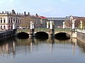
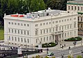
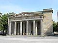
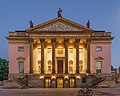
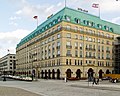
Since 1937, the numbering of the properties on the street has started at the Schlossbrücke (Palace Bridge), which connects Unter den Linden with the Lustgarten and Museum Island. The reconstructed Alte Kommandantur is at No. 1, standing opposite the Zeughaus arsenal, the oldest building on Unter den Linden, built between 1695 and 1706, now the seat of the Deutsches Historisches Museum, No. 2. Buildings along the street include (from east to west) the Crown Prince's Palace (the former palace of the Hohenzollern crown princes), at No. 3, opposite the Neue Wache war memorial, No. 4, Karl Friedrich Schinkel’s masterpiece built in 1817. Further along, on Bebelplatz, the Berlin State Opera, No. 7, colloquially called Lindenoper, St. Hedwig's Cathedral and the Altes Palais, No. 9, (Old Palace, Berlin) a favourite Neoclassical residence of Emperor Wilhelm I; next, on the north side lies the main building of the Humboldt University, No. 6, and House I of the Berlin State Library, No. 8. At the western end are the Russian Embassy (former Soviet Embassy, Nos. 63-65, the Hungarian Embassy, No. 76, standing at the junction with Wilhelmstrasse, and finally the Hotel Adlon, No. 77, at the corner of Pariser Platz, which has been completely rebuilt on the site of the pre-war hotel. Well-known statues of Alexander and Wilhelm von Humboldt in front of the university as well as of the Prussian generals Scharnhorst and Bülow, also adorn the street. A street sign carrying the name Unter den Linden dating from before the 1930s was taken away by British forces and can now be seen at the Imperial War Museum, London.
Along Unter den Linden
-
 Berlin Cathedral from the River Spree
 -
 Unter den Linden at night
 -
 Christmas illumination
 -
 Eastern end at Schlossbrücke (Castle Bridge)
 -
-

-
 Neue Wache (New Guard House) memorial
 -
-
 Main building of Humboldt University
 -
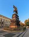 Equestrian statue of Frederick the Great, facing east
 -
-
 Brandenburg Gate at Pariser Platz, which marks the western terminus
 -

-
 The reconstructed Berlin Palace
.jpg)


.jpg)


See also
- Berlin Brandenburger Tor station – formerly Berlin Unter den Linden
- Berlin Unter den Linden station – U-Bahn station at the Friedrichstraße intersection, served by U5 and U6 trains.
External links
- Unter den Linden - Interactive 360° Panorama
- Webcam: Live-View of the street Unter den Linden with Brandenburg Gate in Berlin, Germany

| International | |
|---|---|
| National | |