
Carrollton, Alabama: Difference between revisions
KolbertBot (talk | contribs) m Bot: HTTP→HTTPS (v477) |
No edit summary Tags: Mobile edit Mobile web edit Disambiguation links added |
||
| (30 intermediate revisions by 19 users not shown) | |||
| Line 1: | Line 1: | ||
{{Short description|City in and county seat of Pickens County, Alabama}} |
|||
{{Use mdy dates|date=March 2024}} |
|||
{{Infobox settlement |
{{Infobox settlement |
||
|official_name = Carrollton, Alabama |
|official_name = Carrollton, Alabama |
||
| Line 4: | Line 6: | ||
|image_skyline = Pickens County Courthouse 2.jpg |
|image_skyline = Pickens County Courthouse 2.jpg |
||
|imagesize = |
|imagesize = |
||
|image_caption = Pickens County Courthouse in Carrollton |
|image_caption = [[Pickens County Courthouse]] in Carrollton |
||
|image_seal = |
|image_seal = |
||
|image_map = File:Pickens County Alabama Incorporated and Unincorporated areas Carrollton Highlighted 0112304.svg |
|image_map = File:Pickens County Alabama Incorporated and Unincorporated areas Carrollton Highlighted 0112304.svg |
||
| Line 12: | Line 14: | ||
|mapsize1 = |
|mapsize1 = |
||
|map_caption1 = |
|map_caption1 = |
||
|subdivision_type = [[List of |
|subdivision_type = [[List of sovereign states|Country]] |
||
|subdivision_type1 = [[ |
|subdivision_type1 = [[U.S. state|State]] |
||
|subdivision_type2 = [[List of counties in Alabama|County]] |
|subdivision_type2 = [[List of counties in Alabama|County]] |
||
|subdivision_name = |
|subdivision_name = United States |
||
|subdivision_name1 = [[Alabama]] |
|subdivision_name1 = [[Alabama]] |
||
|subdivision_name2 = [[Pickens County, Alabama|Pickens]] |
|subdivision_name2 = [[Pickens County, Alabama|Pickens]] |
||
| Line 23: | Line 25: | ||
|established_date = |
|established_date = |
||
|area_magnitude = |
|area_magnitude = |
||
| ⚫ | |||
|area_total_sq_mi = 2.08 |
|area_total_sq_mi = 2.08 |
||
| ⚫ | |||
|area_land_sq_mi = 2.06 |
|area_land_sq_mi = 2.06 |
||
| ⚫ | |||
|area_water_sq_mi = 0.02 |
|area_water_sq_mi = 0.02 |
||
|elevation_ft = 243 |
|elevation_ft = 243 |
||
| |
|population_as_of = [[2020 United States Census|2020]] |
||
|population_as_of = [[2010 United States Census|2010]] |
|||
|population_footnotes = |
|population_footnotes = |
||
|population_total = |
|population_total = 1023 |
||
|population_metro = |
|population_metro = |
||
| ⚫ | |||
| ⚫ | |||
| ⚫ | |||
|timezone = [[Central Time Zone (North America)|Central (CST)]] |
|timezone = [[Central Time Zone (North America)|Central (CST)]] |
||
|utc_offset = -6 |
|utc_offset = -6 |
||
| Line 44: | Line 41: | ||
|postal_code_type = [[ZIP code]] |
|postal_code_type = [[ZIP code]] |
||
|postal_code = 35447 |
|postal_code = 35447 |
||
|area_code = [[Area |
|area_code = [[Area codes 205 and 659|205, 659]] |
||
|blank_name = [[Federal Information Processing Standard|FIPS code]] |
|blank_name = [[Federal Information Processing Standard|FIPS code]] |
||
|blank_info = 01-12304 |
|blank_info = 01-12304 |
||
| Line 51: | Line 48: | ||
|footnotes = |
|footnotes = |
||
|website = |
|website = |
||
|pop_est_as_of = |
|pop_est_as_of = |
||
|pop_est_footnotes = |
|pop_est_footnotes = |
||
|population_est = |
|population_est = |
||
|unit_pref = Imperial |
|unit_pref = Imperial |
||
|area_footnotes = <ref name=" |
|area_footnotes = <ref name="CenPopGazetteer2020">{{cite web|title=2020 U.S. Gazetteer Files|url=https://www2.census.gov/geo/docs/maps-data/data/gazetteer/2020_Gazetteer/2020_gaz_place_01.txt|publisher=United States Census Bureau|accessdate=October 29, 2021}}</ref> |
||
| ⚫ | |||
| ⚫ | |||
| ⚫ | |||
| ⚫ | |||
}} |
}} |
||
'''Carrollton''' is a |
'''Carrollton''' is a city in and the county seat of [[Pickens County, Alabama|Pickens County]], [[Alabama]], United States.<ref name="GR6">{{cite web|url=http://www.naco.org/Counties/Pages/FindACounty.aspx |access-date=June 7, 2011 |title=Find a County |publisher=National Association of Counties |url-status=dead |archive-url=https://web.archive.org/web/20110531210815/http://www.naco.org/Counties/Pages/FindACounty.aspx |archive-date=May 31, 2011 }}</ref> At the 2010 census the population was 1,019, up from 987 in 2000.<ref name="GR6"/> |
||
The [[Pickens County Courthouse (Alabama)|Pickens County Courthouse]] in the center of Carrollton was erected in 1877. The first courthouse in Carrollton was burned on April 5, 1865 by troops of [[Union army|Union]] General [[John T. Croxton]]. A second courthouse was |
The [[Pickens County Courthouse (Alabama)|Pickens County Courthouse]] in the center of Carrollton was erected in 1877. The first courthouse in Carrollton was burned on April 5, 1865, by troops of [[Union army|Union]] General [[John T. Croxton]]. A second courthouse was destroyed by a fire on November 16, 1876. |
||
==History== |
==History== |
||
Incorporated in 1831, the town was named after [[Charles Carroll of |
Incorporated in 1831, the town was named after [[Charles Carroll of Carrollton]], [[Maryland]], the only Roman Catholic and longest-living signer of the Declaration of Independence.<ref>{{cite news | url=https://news.google.com/newspapers?id=BhUhAAAAIBAJ&sjid=DZsEAAAAIBAJ&pg=6053%2C2838607 | title=Maryland patriot gave city name | work=The Tuscaloosa News | date=September 19, 1965 | access-date=May 28, 2015 | author=Watkins, Ed | pages=18}}</ref> A post office has been in operation at Carrollton since 1831.<ref>{{cite web | url=http://www.postalhistory.com/postoffices.asp?task=display&state=AL&county=Pickens | title=Pickens County | publisher=Jim Forte Postal History | access-date=May 28, 2015}}</ref> |
||
As was typical, the county jail was located at the courthouse. The courthouse square was used frequently as a site for public [[Lynchings in the United States|lynchings by whites]] of African Americans, part of numerous efforts to suppress them during a time of high tensions as whites struggled for dominance. It was part of a program of intimidation and racial [[terrorism]], with these murders frequent in the decades on either side of the turn of the 20th century. Among the numerous African Americans lynched in Carrollton was John Gibson, hanged on August 28, 1907.<ref name="Gibson">{{cite news|title=Negro Lynched|url=https://chroniclingamerica.loc.gov/lccn/sn83016943/1907-08-31/ed-1/seq-2/|access-date=December 16, 2017|publisher=Macon Beacon|date=August 31, 1907}}</ref> Pickens County had the fifth highest total of lynchings in Alabama, according to ''Lynching in America'' (2015, 3rd edition), published by the [[Equal Justice Initiative]]. |
|||
==Geography== |
==Geography== |
||
Carrollton is located at {{coord|33|15|39|N|88|5|40|W|type:city}} (33.260858, -88.094452).<ref name="GR1">{{cite web|url= |
Carrollton is located at {{coord|33|15|39|N|88|5|40|W|type:city}} (33.260858, -88.094452).<ref name="GR1">{{cite web|url=https://www.census.gov/geographies/reference-files/time-series/geo/gazetteer-files.html|publisher=[[United States Census Bureau]]|access-date=April 23, 2011|date=February 12, 2011|title=US Gazetteer files: 2010, 2000, and 1990}}</ref> |
||
According to the [[U.S. Census Bureau]], the town has a total area of {{convert|2.1|sqmi|km2}}, of which {{convert|2.1|sqmi|km2}} is land and {{convert|0.04|sqmi|km2}} (0.96%) is water. |
According to the [[U.S. Census Bureau]], the town has a total area of {{convert|2.1|sqmi|km2}}, of which {{convert|2.1|sqmi|km2}} is land and {{convert|0.04|sqmi|km2}} (0.96%) is water. |
||
| Line 85: | Line 88: | ||
|2000= 987 |
|2000= 987 |
||
|2010= 1019 |
|2010= 1019 |
||
|2020= 1023 |
|||
|estyear=2016 |
|||
|estimate=980 |
|||
|estref=<ref name="USCensusEst2016">{{cite web|url=https://www.census.gov/programs-surveys/popest/data/tables.2016.html|title=Population and Housing Unit Estimates|accessdate=June 9, 2017}}</ref> |
|||
|align-fn=center |
|align-fn=center |
||
|footnote=U.S. Decennial Census<ref>{{cite web|url= |
|footnote=U.S. Decennial Census<ref>{{cite web|url=https://www.census.gov/programs-surveys/decennial-census.html|title=U.S. Decennial Census|publisher=Census.gov|access-date=June 6, 2013}}</ref><br>2013 Estimate<ref>{{cite web|url=https://www.census.gov/popest/data/cities/totals/2013/SUB-EST2013-3.html|title=Annual Estimates of the Resident Population: April 1, 2010 to July 1, 2013|access-date=June 3, 2014}}</ref> |
||
}} |
}} |
||
===2020 census=== |
|||
| ⚫ | As of the [[2010 United States Census]], there were 1,019 people |
||
{| class="wikitable" |
|||
|+Carrollton racial composition<ref>{{Cite web|title=Explore Census Data|url=https://data.census.gov/cedsci/table?g=1600000US0112304&tid=DECENNIALPL2020.P2|access-date=December 11, 2021|website=data.census.gov}}</ref> |
|||
!Race |
|||
!Num. |
|||
!Perc. |
|||
|- |
|||
|[[White (U.S. Census)|White]] (non-Hispanic) |
|||
|479 |
|||
|46.82% |
|||
|- |
|||
|[[African American (U.S. Census)|Black or African American]] (non-Hispanic) |
|||
|398 |
|||
|38.91% |
|||
|- |
|||
|[[Native American (U.S. Census)|Native American]] |
|||
|1 |
|||
|0.1% |
|||
|- |
|||
|[[Asian (U.S. Census)|Asian]] |
|||
|2 |
|||
|0.2% |
|||
|- |
|||
|[[Race (United States Census)|Other/Mixed]] |
|||
|41 |
|||
|4.01% |
|||
|- |
|||
|[[Hispanic (U.S. Census)|Hispanic]] or [[Latino (U.S. Census)|Latino]] |
|||
|102 |
|||
|9.97% |
|||
|} |
|||
As of the [[2020 United States census]], there were 1,023 people, 353 households, and 218 families residing in the town. |
|||
===2010 census=== |
|||
| ⚫ | As of the [[census]]<ref name="GR2">{{cite web |url= |
||
| ⚫ | As of the [[2010 United States Census]], there were 1,019 people living in the town. 49.0% were [[White (U.S. Census)|White]], 43.1% [[African American (U.S. Census)|African American]], 0.1% [[Native American (U.S. Census)|Native American]], 3.6% from some other race and 4.2% [[Multiracial American|of two or more races]]. 10.4% were [[Hispanic (U.S. Census)|Hispanic]] or [[Latino (U.S. Census)|Latino]] of any race. |
||
===2000 census=== |
|||
There were 384 households out of which 35.2% had children under the age of 18 living with them, 40.1% were [[Marriage|married couples]] living together, 28.9% had a female householder with no husband present, and 27.3% were non-families. 25.5% of all households were made up of individuals and 14.8% had someone living alone who was 65 years of age or older. The average household size was 2.57 and the average family size was 3.07. |
|||
| ⚫ | As of the [[census]]<ref name="GR2">{{cite web |url=https://www.census.gov |publisher=[[United States Census Bureau]] |access-date=January 31, 2008 |title=U.S. Census website }}</ref> of 2000, there were 987 people, 384 households, and 279 families living in the town. The population density was {{convert|479.1|PD/sqmi|PD/km2|sp=us|adj=off}}. There were 437 housing units at an average density of {{convert|212.1|/sqmi|/km2|sp=us|adj=off}}. The racial makeup of the town was 53.39% [[Race (United States Census)|White]], 44.58% [[Race (United States Census)|Black]] or [[Race (United States Census)|African American]], 0.10% [[Race (United States Census)|Asian]], and 1.93% from two or more races. 0.41% of the population were [[Race (United States Census)|Hispanic]] or [[Race (United States Census)|Latino]] of any race. |
||
There were 384 households, out of which 35.2% had children under the age of 18 living with them, 40.1% were [[Marriage|married couples]] living together, 28.9% had a female householder with no husband present, and 27.3% were non-families. 25.5% of all households were made up of individuals, and 14.8% had someone living alone who was 65 years of age or older. The average household size was 2.57 and the average family size was 3.07. |
|||
In the town, the population was spread out, with 29.4% under the age of 18, 10.5% from 18 to 24, 23.7% from 25 to 44, 20.5% from 45 to 64, and 15.9% who were 65 years of age or older. The median age was 34 years. For every 100 females, there were 77.8 males. For every 100 females age 18 and over, there were 65.2 males. |
|||
The median income for a household in the town was $24,318, and the median income for a family was $29,612. Males had a median income of $30,833 versus $18,333 for females. The [[per capita income]] for the town was $12,153. About 31.4% of families and 38.5% of the population were below the [[poverty line]], including 56.9% of those under age 18 and 26.1% of those age 65 or over. |
The median income for a household in the town was $24,318, and the median income for a family was $29,612. Males had a median income of $30,833 versus $18,333 for females. The [[per capita income]] for the town was $12,153. About 31.4% of families and 38.5% of the population were below the [[poverty line]], including 56.9% of those under age 18 and 26.1% of those age 65 or over. |
||
==Education== |
==Education== |
||
| Line 120: | Line 157: | ||
==References== |
==References== |
||
{{reflist}} |
|||
<references /> |
|||
*{{cite book | author=Windham, Kathryn Tucker | title=13 Alabama Ghosts and Jeffrey | publisher=Strode | year=1969 | isbn=0-87397-008-X}} |
*{{cite book | author=Windham, Kathryn Tucker | title=13 Alabama Ghosts and Jeffrey | publisher=Strode | year=1969 | isbn=0-87397-008-X}} |
||
{{Coord|display=title|33.260858|-88.094452}} |
{{Coord|display=title|33.260858|-88.094452}} |
||
{{Pickens County, Alabama}} |
{{Pickens County, Alabama}} |
||
{{Alabama county seats}} |
|||
{{authority control}} |
|||
[[Category:Towns in Pickens County, Alabama]] |
[[Category:Towns in Pickens County, Alabama]] |
||
Latest revision as of 02:16, 24 August 2024
Carrollton, Alabama | |
|---|---|
 Pickens County Courthouse in Carrollton | |
 Location of Carrollton in Pickens County, Alabama. | |
| Coordinates: 33°15′39″N 88°5′40″W / 33.26083°N 88.09444°W | |
| Country | United States |
| State | Alabama |
| County | Pickens |
| Area | |
| • Total | 2.08 sq mi (5.39 km2) |
| • Land | 2.06 sq mi (5.33 km2) |
| • Water | 0.02 sq mi (0.06 km2) |
| Elevation | 243 ft (74 m) |
| Population (2020) | |
| • Total | 1,023 |
| • Density | 497.08/sq mi (191.88/km2) |
| Time zone | UTC-6 (Central (CST)) |
| • Summer (DST) | UTC-5 (CDT) |
| ZIP code | 35447 |
| Area code(s) | 205, 659 |
| FIPS code | 01-12304 |
| GNIS feature ID | 0135481 |
Carrollton is a city in and the county seat of Pickens County, Alabama, United States.[2] At the 2010 census the population was 1,019, up from 987 in 2000.[2]
The Pickens County Courthouse in the center of Carrollton was erected in 1877. The first courthouse in Carrollton was burned on April 5, 1865, by troops of Union General John T. Croxton. A second courthouse was destroyed by a fire on November 16, 1876.
History
[edit]Incorporated in 1831, the town was named after Charles Carroll of Carrollton, Maryland, the only Roman Catholic and longest-living signer of the Declaration of Independence.[3] A post office has been in operation at Carrollton since 1831.[4]
As was typical, the county jail was located at the courthouse. The courthouse square was used frequently as a site for public lynchings by whites of African Americans, part of numerous efforts to suppress them during a time of high tensions as whites struggled for dominance. It was part of a program of intimidation and racial terrorism, with these murders frequent in the decades on either side of the turn of the 20th century. Among the numerous African Americans lynched in Carrollton was John Gibson, hanged on August 28, 1907.[5] Pickens County had the fifth highest total of lynchings in Alabama, according to Lynching in America (2015, 3rd edition), published by the Equal Justice Initiative.
Geography
[edit]Carrollton is located at 33°15′39″N 88°5′40″W / 33.26083°N 88.09444°W (33.260858, -88.094452).[6]
According to the U.S. Census Bureau, the town has a total area of 2.1 square miles (5.4 km2), of which 2.1 square miles (5.4 km2) is land and 0.04 square miles (0.10 km2) (0.96%) is water.
Demographics
[edit]| Census | Pop. | Note | %± |
|---|---|---|---|
| 1850 | 394 | — | |
| 1880 | 349 | — | |
| 1900 | 278 | — | |
| 1910 | 444 | 59.7% | |
| 1920 | 564 | 27.0% | |
| 1930 | 569 | 0.9% | |
| 1940 | 626 | 10.0% | |
| 1950 | 710 | 13.4% | |
| 1960 | 894 | 25.9% | |
| 1970 | 923 | 3.2% | |
| 1980 | 1,104 | 19.6% | |
| 1990 | 1,170 | 6.0% | |
| 2000 | 987 | −15.6% | |
| 2010 | 1,019 | 3.2% | |
| 2020 | 1,023 | 0.4% | |
| U.S. Decennial Census[7] 2013 Estimate[8] | |||
2020 census
[edit]| Race | Num. | Perc. |
|---|---|---|
| White (non-Hispanic) | 479 | 46.82% |
| Black or African American (non-Hispanic) | 398 | 38.91% |
| Native American | 1 | 0.1% |
| Asian | 2 | 0.2% |
| Other/Mixed | 41 | 4.01% |
| Hispanic or Latino | 102 | 9.97% |
As of the 2020 United States census, there were 1,023 people, 353 households, and 218 families residing in the town.
2010 census
[edit]As of the 2010 United States Census, there were 1,019 people living in the town. 49.0% were White, 43.1% African American, 0.1% Native American, 3.6% from some other race and 4.2% of two or more races. 10.4% were Hispanic or Latino of any race.
2000 census
[edit]As of the census[10] of 2000, there were 987 people, 384 households, and 279 families living in the town. The population density was 479.1 inhabitants per square mile (185.0/km2). There were 437 housing units at an average density of 212.1 per square mile (81.9/km2). The racial makeup of the town was 53.39% White, 44.58% Black or African American, 0.10% Asian, and 1.93% from two or more races. 0.41% of the population were Hispanic or Latino of any race.
There were 384 households, out of which 35.2% had children under the age of 18 living with them, 40.1% were married couples living together, 28.9% had a female householder with no husband present, and 27.3% were non-families. 25.5% of all households were made up of individuals, and 14.8% had someone living alone who was 65 years of age or older. The average household size was 2.57 and the average family size was 3.07.
In the town, the population was spread out, with 29.4% under the age of 18, 10.5% from 18 to 24, 23.7% from 25 to 44, 20.5% from 45 to 64, and 15.9% who were 65 years of age or older. The median age was 34 years. For every 100 females, there were 77.8 males. For every 100 females age 18 and over, there were 65.2 males.
The median income for a household in the town was $24,318, and the median income for a family was $29,612. Males had a median income of $30,833 versus $18,333 for females. The per capita income for the town was $12,153. About 31.4% of families and 38.5% of the population were below the poverty line, including 56.9% of those under age 18 and 26.1% of those age 65 or over.
Education
[edit]The Pickens County Board of Education is located in Carrollton. Students in the area can attend Carrollton Elementary School for Grades K-6. Carrollton is also the home of the Pickens County Educational Center, a branch of Bevill State Community College.
Notable people
[edit]- Hanley Funderburk, president of Auburn University from 1980 to 1983
- Walter Jones, NFL All Pro football player and part of the NFL Hall of Fame
- John H. Kelly, one of the youngest generals to die during the American Civil War at the age of 24
- Homer H. Norton, head coach for Texas A&M from 1934 to 1947. Inducted into the College Football Hall of Fame in 1971.
- Courtney Taylor, former Auburn University and Seattle Seahawks wide receiver
Gallery
[edit]Below are photographs taken in Carrollton as part of the Historic American Buildings Survey conducted during the Great Depression to document the buildings across the US:
-
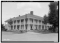 Phoenix Hotel
 -
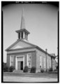 Methodist Episcopal Church


References
[edit]- ^ "2020 U.S. Gazetteer Files". United States Census Bureau. Retrieved October 29, 2021.
- ^ a b "Find a County". National Association of Counties. Archived from the original on May 31, 2011. Retrieved June 7, 2011.
- ^ Watkins, Ed (September 19, 1965). "Maryland patriot gave city name". The Tuscaloosa News. p. 18. Retrieved May 28, 2015.
- ^ "Pickens County". Jim Forte Postal History. Retrieved May 28, 2015.
- ^ "Negro Lynched". Macon Beacon. August 31, 1907. Retrieved December 16, 2017.
- ^ "US Gazetteer files: 2010, 2000, and 1990". United States Census Bureau. February 12, 2011. Retrieved April 23, 2011.
- ^ "U.S. Decennial Census". Census.gov. Retrieved June 6, 2013.
- ^ "Annual Estimates of the Resident Population: April 1, 2010 to July 1, 2013". Retrieved June 3, 2014.
- ^ "Explore Census Data". data.census.gov. Retrieved December 11, 2021.
- ^ "U.S. Census website". United States Census Bureau. Retrieved January 31, 2008.
- Windham, Kathryn Tucker (1969). 13 Alabama Ghosts and Jeffrey. Strode. ISBN 0-87397-008-X.
33°15′39″N 88°05′40″W / 33.260858°N 88.094452°W
Municipalities and communities of Pickens County, Alabama, United States | ||
|---|---|---|
| Cities |  | |
| Towns | ||
| CDP | ||
| Unincorporated communities | ||