
Cucunubá: Difference between revisions
Rescuing 0 sources and tagging 1 as dead. #IABot (v2.0beta15) |
GreenC bot (talk | contribs) Rescued 1 archive link; reformat 1 link. Wayback Medic 2.5 |
||
| Line 58: | Line 58: | ||
|footnotes = |
|footnotes = |
||
}} |
}} |
||
'''Cucunubá''' is a municipality and town of [[Colombia]] in the [[Ubaté Province]], part of the [[Departments of Colombia|department]] of [[Cundinamarca Department|Cundinamarca]]. It borders with the municipalities of [[Ubaté]], [[Lenguazaque]], [[Suesca]], [[Chocontá]], [[Tausa]] and [[Sutatausa]].<ref name=websiteCucunuba>{{es}} [http://www.cucunuba-cundinamarca.gov.co/informacion_general.shtml Official website Cucunubá] |
'''Cucunubá''' is a municipality and town of [[Colombia]] in the [[Ubaté Province]], part of the [[Departments of Colombia|department]] of [[Cundinamarca Department|Cundinamarca]]. It borders with the municipalities of [[Ubaté]], [[Lenguazaque]], [[Suesca]], [[Chocontá]], [[Tausa]] and [[Sutatausa]].<ref name=websiteCucunuba>{{es}} [https://archive.today/20150522161227/http://www.cucunuba-cundinamarca.gov.co/informacion_general.shtml Official website Cucunubá]</ref> |
||
== Geography == |
== Geography == |
||
Revision as of 02:58, 13 October 2019
Cucunubá | |
|---|---|
Municipality and town | |
.jpg) View of Cucunubá | |
.svg) Flag  Seal | |
 Location of the municipality and town inside Cundinamarca Department of Colombia | |
 Cucunubá Location in Colombia | |
| Coordinates: 5°15′0″N 73°45′48″W / 5.25000°N 73.76333°W | |
| Country | |
| Department | |
| Province | Ubaté Province |
| Founded | 2 August 1600 |
| Founded by | Luis Enríquez |
| Government | |
| • Mayor | Sandra Liliana Jara Alonso (2016-2019) |
| Area | |
| • Municipality and town | 112 km2 (43 sq mi) |
| • Urban | 1.12 km2 (0.43 sq mi) |
| Elevation | 2,590 m (8,500 ft) |
| Population (2015) | |
| • Municipality and town | 7,479 |
| • Density | 67/km2 (170/sq mi) |
| • Urban | 1,383 |
| Time zone | UTC-5 (Colombia Standard Time) |
| Website | Official website |
Cucunubá is a municipality and town of Colombia in the Ubaté Province, part of the department of Cundinamarca. It borders with the municipalities of Ubaté, Lenguazaque, Suesca, Chocontá, Tausa and Sutatausa.[1]
Geography
The urban centre of the municipality is located in the Ubaté Valley at an altitude of 2,590 metres (8,500 ft), while other parts stretch over the mountainous sectors of the Eastern Ranges of the Colombian Andes. The urban centre is at a distance of 90 kilometres (56 mi) from the capital Bogotá.
Etymology
The name Cucunubá comes from Chibcha and means "Similarity to a face".[1][2]
History
Cucunubá in the times before the Spanish conquest was part of the Muisca Confederation, a loose confederation of rulers of the Muisca.
Modern Cucunubá was founded on August 2, 1600 by Luis Enríquez.[1]
Economy
Main economical activity of Cucunubá is carbon mining. More than half of the municipality's area is covered with farmfields and livestock farming producers. Main agricultural products are potatoes, peas and wheat.[1]
Gallery
-
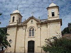 Church of Cucunubá
 -
 Church


References
| Gold |  | |
|---|---|---|
| Silver | ||
| Platinum | ||
| Nickel | ||
| Coltan | ||
| Emeralds | ||
| Coal | ||
| Salt | ||
| Sources | ||