
Arda (Maritsa tributary)
| Arda | |
|---|---|
 | |
| Physical characteristics | |
| Mouth | Maritsa, near Edirne 41°39′39″N 26°29′42″E / 41.66083°N 26.49500°E |
| Length | 290 km (241 km in Bulgaria) |

The Arda ([Арда, Arda] Error: {{Lang-xx}}: text has italic markup (help), Turkish: Arda, Greek: Άρδας, Árdas) is a river whose source lies in the Bulgarian Rhodope Mountains near the town of Smolyan, flowing 290 kilometres eastward past Kardzhali and Ivaylovgrad and through Greece in the northern portion of the Evros prefecture including Kastanies. It then enters the Maritsa (Greek: Έβρος, Evros) just west of Edirne, Turkey. The portion in Bulgaria is accented by three hydroelectric and irrigation dams, Kardzhali Dam, Studen Kladenets and Ivaylovgrad Dam, and is 241 km long, making the Arda the longest river in the Rhodopes. The medieval Dyavolski most arch bridge crosses the river 10 km from Ardino.
The three floods of February 18, 2005, when the water level was at 4.8 m, March 1 and March 7, 2005 flooded the low lying areas, especially in the Kastanies area which turned the area into a lagoon. The merging of the waters of the Maritsa (Evros/Meriç) caused streets and buildings including homes to be flooded and people to be stranded in their homes.
Arda Peak on Livingston Island in the South Shetland Islands, Antarctica and the mineral ardaite are named after the Arda river.
Gallery
-
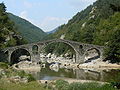 Devil's bridge near Ardino
 -
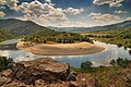 Arda's Meander in Bulgaria
 -
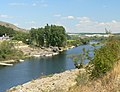
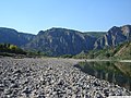 Near Madzharovo
 -
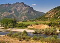 Near Madzharovo
 -


This Bulgaria location article is a stub. You can help Wikipedia by expanding it. |
This Greece location article is a stub. You can help Wikipedia by expanding it. |
This article about a Marmara Region of Turkey location is a stub. You can help Wikipedia by expanding it. |