
Portal:Indiana
The Indiana Portal

Various indigenous peoples inhabited what would become Indiana for thousands of years, some of whom the U.S. government expelled between 1800 and 1836. Indiana received its name because the state was largely possessed by native tribes even after it was granted statehood. Since then, settlement patterns in Indiana have reflected regional cultural segmentation present in the Eastern United States; the state's northernmost tier was settled primarily by people from New England and New York, Central Indiana by migrants from the Mid-Atlantic states and adjacent Ohio, and Southern Indiana by settlers from the Upland South, particularly Kentucky and Tennessee.
Indiana has a diverse economy with a gross state product of $352.62 billion in 2021. It has several metropolitan areas with populations greater than 100,000 and a number of smaller cities and towns. Indiana is home to professional sports teams, including the NFL's Indianapolis Colts and the NBA's Indiana Pacers. The state also hosts several notable competitive events, such as the Indianapolis 500, held at Indianapolis Motor Speedway. (Full article...)
Selected article -

The Indiana Mammoth Internal Improvement Act was a law passed by the Indiana General Assembly and signed by Whig Governor Noah Noble in 1836 that greatly expanded the state's program of internal improvements. It added $10 million to spending and funded several projects, including turnpikes, canals, and later, railroads. The following year the state economy was adversely affected by the Panic of 1837 and the overall project ended in a near total disaster for the state, which narrowly avoided total bankruptcy from the debt.
By 1841, the government could no longer make the interest payments, and all the projects, except the largest canal, were handed over to the state's London creditors in exchange for a 50% reduction in debt. Again in 1846, the last project was handed over for another 50% reduction in the debt. Of the eight projects in the measure, none were completed by the state and only two were finished by the creditors who took them over. (Full article...)Selected image -
 |
Did you know -
- ... that LGBT rights activist Kit Malone helped create the first transgender organized marching group in the Indianapolis Pride Parade's history?
- ... that the Indy Bag Ladies, one of the oldest AIDS fundraising organizations, is a group of activist drag queens in Indianapolis who have raised more than $1 million for AIDS patients?
- ... that Indianapolis's 2023 gun control ordinance – which bans assault weapons, among other measures – is a trigger law that only goes into effect if Indiana's state preemption law is repealed or struck down?
- ... that the Indianapolis Community Food Access Coalition was created to resolve food deserts in the city of Indianapolis?
- ... that the Circle Tower, an Art Deco building in Indianapolis, features ziggurat-like upper floors?
- ... that the veto of an Indiana law that bans transgender girls from participating in school sports was overridden by the state legislature?
Related portals
Selected geographic article -
Selected biography -
Alvin Nugent "Bo" McMillin (January 12, 1895 – March 31, 1952) was an American football player and coach at the collegiate and professional level. He played college football at Centre College in Danville, Kentucky, where he was a three-time All-American at quarterback, and led the Centre Praying Colonels to an upset victory over Harvard in 1921. McMillin was inducted into the College Football Hall of Fame as a player as part of its inaugural 1951 class.
McMillin was the head football coach at Centenary College of Louisiana (1922–1924), Geneva College (1925–1927), Kansas State University (1928–1933) and Indiana University (1934–1947), compiling a career college football coaching record of 140–77–13. In 1945, he led Indiana to its first Big Ten Conference title and was named AFCA Coach of the Year. (Full article...)Selected quote
General images
-
 The Constitution Elm in Corydon (from History of Indiana)
 -
 Map of the Indiana Territory (from History of Indiana)
 -
 The Circle in Indianapolis, circa 1898 (from History of Indiana)
 -
-
 Madame C. J. Walker, Indianapolis entrepreneur and philanthropist (from History of Indiana)
 -
 80th Indiana Infantry Regiment and the 19th Indiana Light Artillery defending against the Confederates at the Battle of Perryville by H. Mosler (from History of Indiana)
 -
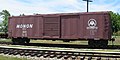 A restored Monon boxcar at the Linden Railroad Museum in Linden, Indiana (from History of Indiana)
 -
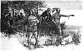 Native Americans guide French explorers through Indiana as depicted by Maurice Thompson in Stories of Indiana. (from History of Indiana)
 -
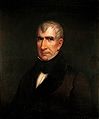 William Henry Harrison, the 1st Governor of Indiana Territory from 1801 to 1812, and the 9th President of the United States (from History of Indiana)
 -
-
 The fifth Indiana Statehouse in Indianapolis built in 1888 on the site of the third statehouse (from History of Indiana)
 -
-
 View of Mound A at Angel Mounds (from History of Indiana)
 -
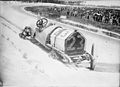 Driver Mel Marquette's wrecked McFarlan racing car at the 1912 Indianapolis 500 (from History of Indiana)
 -
 Oliver Hazard Perry Morton, governor 1861 to 1867 (from History of Indiana)
 -
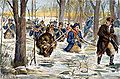 Clark's march to Vincennes, by F. C. Yohn (from History of Indiana)


.jpg)


Topics

- Economy: AM General - ATA Airlines - Casinos - Cummins - Delta - ITT - JayC - Lilly - Limestone - Manufacturing - NiSource - Shoe Carnival - Simon Property Group - Soybeans - Studebaker - Vectren - WellPoint
- Geography: Caves - Lakes - Rivers - State forests - Watersheds
| Executive |  | |
|---|---|---|
| Legislature | ||
| Judiciary | ||
| Departments | ||
| Local government | ||
| Law | ||
Sports teams based in Indiana | |||||||||
|---|---|---|---|---|---|---|---|---|---|
| Baseball |  | ||||||||
| Basketball | |||||||||
| Football | |||||||||
| Hockey | |||||||||
| Motorsport | |||||||||
| Roller derby | |||||||||
| Soccer | |||||||||
| Ultimate | |||||||||
| Volleyball | |||||||||
| College athletics |
| ||||||||


Categories

Attractions


 |

Recognized content
| This is a list of recognized content, updated weekly by JL-Bot (talk · contribs) (typically on Saturdays). There is no need to edit the list yourself. If an article is missing from the list, make sure it is tagged (e.g. {{WikiProject Indiana}}) or categorized correctly and wait for the next update. See WP:RECOG for configuration options. |
Good articles
- 1963 Indiana State Fairgrounds Coliseum gas explosion
- 2006 Brickyard 400
- 2011 South Bend mayoral election
- 2015 South Bend mayoral election
- 2019 South Bend mayoral election
- 2021 NCAA Division I men's basketball championship game
- Max Bielfeldt
- The Fault in Our Stars (film)
- Hurley Goodall
- R. Ames Montgomery
- Proposed South Shore Line station in South Bend
- Richmond, Indiana, facility fire
- WCAE
Featured pictures
-
 Kenje Ogata 1943
 -
 Kurt Vonnegut by Bernard Gotfryd (1965)
 -
 US-NBN-IL-Lebanon-2057-Orig-1-400-C

.jpg)

WikiProjects
State facts
Indiana | |
|---|---|
| Country | United States |
| Admitted to the Union | December 11, 1816 (19th) |
| Capital | Indianapolis |
| Largest city | Indianapolis |
| Largest metro and urban areas | Indianapolis-Carmel MSA |
| Government | |
| • Governor | Eric Holcomb (R) (2017) |
| • Lieutenant Governor | Suzanne Crouch (R) (2017) |
| Legislature | Indiana General Assembly |
| • Upper house | Senate |
| • Lower house | House of Representatives |
| U.S. senators | Todd Young (R) Mike Braun (R) |
| Population | |
| • Total | 6,080,485 |
| • Density | 169.5/sq mi (65.46/km2) |
| Language | |
| • Official language | English |
| Latitude | 37° 46′ N to 41° 46′ N |
| Longitude | 84° 47′ W to 88° 6′ W |
.JPG)


Things you can do
 |
Here are some tasks awaiting attention:
|
Associated Wikimedia
The following Wikimedia Foundation sister projects provide more on this subject:
-
 Commons
Free media repository -
 Wikibooks
Free textbooks and manuals -
 Wikidata
Free knowledge base -
 Wikinews
Free-content news -
 Wikiquote
Collection of quotations -
 Wikisource
Free-content library -
 Wikiversity
Free learning tools -
 Wikivoyage
Free travel guide -
 Wiktionary
Dictionary and thesaurus


- ^ a b "Elevations and Distances in the United States". U.S Geological Survey. 29 April 2005. Retrieved 2006-11-06.