Search results
Jump to navigation
Jump to search
Create the page "Solomon Islands" on this wiki! See also the search results found.
 English Flag of the Solomon Islands Hindi सोलोमोन द्वीप का ध्वज Arabic علم جزر سليمان French Drapeau des Îles Salomon Russian Флаг Соломоновых Островов...(1,200 × 600 (1,013 bytes)) - 09:48, 20 July 2024
 Naval ensign of the Solomon Islands, based on Image:Flag of the Solomon Islands.svg. English...(1,200 × 600 (1 KB)) - 17:21, 3 November 2023
 English Nautical chart of the Solomon Islands determination method: SHA-1...(11,641 × 7,952 (20.57 MB)) - 22:46, 26 April 2024
 Civil ensign of the Solomon Islands, based on Image:Flag of the Solomon Islands.svg and an image at the Shipmate Flagchart archive copy at the Wayback...(1,200 × 600 (1 KB)) - 12:14, 18 March 2024
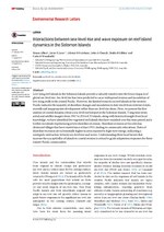 Creative Commons Attribution 3.0 truetrue English Interactions between sea-level rise and wave exposure on reef island dynamics in the Solomon Islands...(1,239 × 1,752 (1.45 MB)) - 14:57, 27 March 2021
 English Nautical chart of Solomon Islands to Ellice Islands...(16,317 × 11,185 (11.26 MB)) - 17:14, 12 June 2024
 Solomon Islands flag 300px height unified for the national flags serie, by user:Marc Mongenet, from CIA World Factbook, borders removed, high compression...(800 × 400 (14 KB)) - 21:12, 25 November 2022
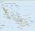 English Political map of the Solomon Islands Amharic ይህ የ ኢ ት ዮ ጵ ያ ነው::...(748 × 650 (72 KB)) - 07:33, 28 March 2024
 English Apportionment diagram of the results of the 2024 Solomon Islands election for the National Parliament...(360 × 185 (5 KB)) - 05:22, 26 April 2024
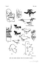 https://creativecommons.org/publicdomain/mark/1.0/PDMCreative Commons Public Domain Mark 1.0falsefalse English Designs from the Solomon Islands...(2,843 × 4,120 (817 KB)) - 17:18, 11 January 2022
 Attribution 4.0 truetrue English Spherical icon of the flag of the Solomon Islands author name string: ReneeWrites Wikimedia username: ReneeWrites URL:...(50 × 50 (4 KB)) - 17:43, 8 January 2024
 Map of: Solomon Islands¤ PNG files: :Image:Solomon Islands Regions map.png This W3C-unspecified vector image was created with Inkscape . This file is...(1,158 × 904 (1.62 MB)) - 20:37, 5 July 2024
 English Nautical chart of Plans in the Solomon Islands...(16,334 × 11,136 (24.3 MB)) - 00:57, 27 July 2024
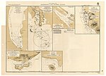 English Nautical chart of Anchorages in the Solomon Islands determination method: SHA-1...(7,168 × 5,152 (4 MB)) - 22:46, 26 April 2024
 https://creativecommons.org/publicdomain/mark/1.0/PDMCreative Commons Public Domain Mark 1.0falsefalse English Map of the Solomon Islands, Melanesia, South Pacific Ocean...(3,648 × 2,176 (755 KB)) - 23:55, 13 October 2023
 English Nautical chart of the Solomon Islands determination method: SHA-1...(7,480 × 5,088 (4.31 MB)) - 20:01, 2 April 2024
 https://creativecommons.org/publicdomain/mark/1.0/PDMCreative Commons Public Domain Mark 1.0falsefalse English Canoe-prow ornament from the Solomon Islands...(444 × 1,288 (48 KB)) - 17:18, 11 January 2022
 en.wikipedia. 2003-08-10 09:57 Pascal 416×302× (14736 bytes) Map of Solomon Islands and where they are from http://www.lib.utexas.edu/maps/australia.html...(416 × 302 (14 KB)) - 23:57, 13 October 2023
 https://creativecommons.org/publicdomain/mark/1.0/PDMCreative Commons Public Domain Mark 1.0falsefalse English Map of the the Solomon Islands and Papua New Guinea...(963 × 551 (131 KB)) - 19:09, 19 November 2022
 images: File:Solomon_Islands.PNG licensed with PD-Demis 2006-08-14T17:54:59Z Michiel1972 932x565 (63761 Bytes) {{Information |Description=Island of {{subst:PAGENAME}}...(932 × 565 (62 KB)) - 23:51, 13 October 2023


