Real Estate
How Much Are Your Neighbors Paying in Rent? (Map)
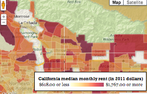
Using the below map you can see monthly rent estimates for neighborhoods all over Southern California.

Have you ever been curious whether you are paying too much (or too little) in rent in your neighborhood?
With the above map, courtesy of the Rich Blocks, Poor Blocks website, you can see data from the federal 2007-2011 American Community Survey that shows the median rents in neighborhoods all over the country.
The site shows the rent by census tracts, which gives a closer view to each neighborhood than a zip code or city wide map would.
In Pasadena, the most expensive rents appear in the areas around the Rose Bowl and along the Arroyo south of the 210 with the higher-density blocks in Central Pasadena also rating pretty highly.
The highest rents overall are in the 4637 tract along Orange Grove Boulevard south of the 210, where the median monthly rent is $1643.
Using the above map you can look at neighborhoods all over the U.S. and also get reports on income levels and poverty rates by census tract.
Do you find the rent in your neighborhood high? Were you surprised at how it compared to other areas in your town? Tell us in the comments.
Get more local news delivered straight to your inbox. Sign up for free Patch newsletters and alerts.