Home & Garden
Initial Snow Accumulation Estimate Made for Ledyard
Snow is expected late Thursday into Friday and temperatures are expected to dip into the teens.

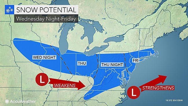
March winds are breezing through the state and snow is on its heels. The National Weather Service is predicting a possible one to three inches of snow for the end of the week.
Temperatures plummet Wednesday afternoon and will fall to the upper 30s by 5 p.m. on the Connecticut Coastline and to the low 30s for interior sections of Connecticut. This is all setting the stage for light snow late Thursday into Friday morning. Some minor snow accumulation is expected, which will likely impact Friday’s commute to work and may impact school schedules too.
Here is the latest information via the National Weather Service:
- Wednesday: Temps fall to the upper 30s on the immediate coastline and into the low 30s for interior sections. Winds could gust between 30 and 45 mph at times.
- Wednesday Night: Cold with temps in the teens to around 20 degrees.
- Thursday: Increasing clouds with temps in the low- to mid-30s.
- Thursday Night: Snow begins for all of Connecticut around 3 to 4 a.m. and continues to fall until noon or 1 p.m. Friday. Temps will be cold enough to support snow. Temps will be in the teens to low-20s.
How Much Snow?
Fairfield, New Haven, New London, and Middlesex counties could see 1-2 inches of snow by Friday afternoon, based on the National Weather Service’s initial snowfall accumulation estimate. New London County could see up to three inches of snow.
Hartford and Tolland counties are currently looking at a half inch to an inch of snow of accumulation by Friday afternoon.
The snow clears out long before the evening commute on Friday and the weekend looks dry. The dry conditions are expected to continue until Tuesday, when temperatures are expected to rise to the mid-50s.
Photo Credit: Accuweather.com
Get more local news delivered straight to your inbox. Sign up for free Patch newsletters and alerts.