Home & Garden
Latest Details on Several Upcoming Snow Possibilities for Ledyard
Winter's not over yet as there are several chances for snow coming up next week and we'll let you know how much we may receive.

It appears we were all premature when we said this winter was a bust.
It’s true northern Connecticut still hasn’t seen the snow it’s accustomed to during a normal winter, but southern Connecticut with the two most recent storms is actually ahead of normal snowfall totals for this time of year.
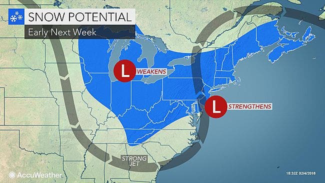
And we have several chances to add to that total next week, but no surprise here, the exact tract of these storms is very uncertain, and we could see several rounds of snow showers, or we see significant accumulation.
Right now, the National Weather Service has issued a “Hazardous Weather Outlook” for all of Fairfield, New Haven, Middlesex and New London counties for snow chances for late Sunday/early Monday and again for Monday into Tuesday.
The weather service says an “offshore storm might produce accumulating snow late Sunday night and Monday,” but right now southern Connecticut is on the “fringe of this intense low pressure system,” but if the track shifts just a bit we could see accumulating snow.
See related stories: Thousands Still Without Power in Connecticut: UPDATE
Another chance for accumulating snow is Monday night and Tuesday, but once again the future track is very uncertain, the National Weather Service states.
According to the latest National Weather Service forecast, if we see snow, it would begin after 2 a.m. Monday and, of course, be an issue for Monday’s commute back to work.
More snow is forecast for the area after 1 p.m. Monday, and according to the National Weather Service snow is possible on Monday evening, Tuesday, Tuesday night, and into Wednesday. There is also a 30 percent chance of snow on Thursday.
WTNH News 8 Meteorologist Sam Kantrow wrote Saturday morning that by the end of Monday we should see 1-3 inches of snow based on the latest computer models, and parts of Connecticut could see up to 6 inches of snow by Wednesday in a long-duration storm that produces steady but not heavy amounts of precipitation.
And after the snow chances calm down by the end of the week, the bitter cold moves in for next weekend, Kantrow says.
NBC Connecticut Meteorologist Darren Sweeney said in a video Saturday morning that we could see a “round of snow” early Monday but the heaviest snow is expected for Cape Cod and eastern Massachusetts.
And as for snow chances next week, Sweeney says right now the snow on Monday and Tuesday and Wednesday into Thursday may just be “glancing blows.”
We’ll continue to update the forecast, and enjoy this weekend as high temps will reach the upper 30s today and we could reach the 40s on Super Bowl Sunday.
Photo credit: Accuweather.com
Get more local news delivered straight to your inbox. Sign up for free Patch newsletters and alerts.