Home & Garden
Snow Makes its Return to Ledyard's Forecast
You can't make this up! Thunderstorms and hail and a sizable snowstorm on the horizon? Here is the latest weather report.

By BRIAN MCCREADY (Patch Staff)
No one ever said Mother Nature doesn’t have a sense of humor. For Thursday, March 17, the morning sun will fade and this afternoon and evening, we may see thunderstorms, small hail and gusty winds across Connecticut.
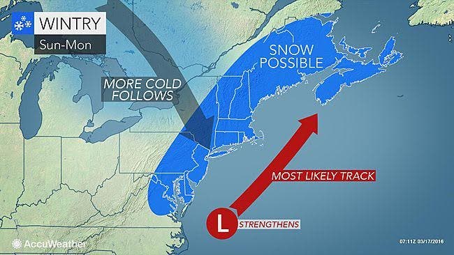
Again, a hit-and-miss potential, depending on where you are. But on the first day of spring this Sunday, chances are increasing that we’ll all see at least some snow in Connecticut.
Here too things could change daily in the forecast, but as of Thursday morning, snow is more likely to fall than not, starting Sunday and continuing into Monday morning.
The National Weather Service issued a Hazardous Weather Outlook for all of Connecticut for Thursday.
Southern Connecticut, which includes all of Fairfield, New Haven, Middlesex, and New London counties:
Isolated thunderstorms with gusty winds and small hail are likely Thursday afternoon, the National Weather Service states. The precipitation is likely to begin between 2 to 4 p.m. and could last until around midnight.
Sunday’s snow?
It seems the stage for snow is being set by a dramatic temperature drop on Saturday, as highs will be just near 40. At night, the entire state falls back into the 20s.
On Sunday, temps won’t hit 40 degrees. Snow and rain are expected after noon and will continue throughout the day and evening hours.
In northern sections of Connecticut, including Hartford and Tolland counties, residents may see all snow. No accumulation estimates have been made, mainly because the storm is days away and the track of the storm is subject to change.
What Connecticut’s weather experts are saying
WTNH News 8 Meteorologist Gil Simmons wrote on Facebook: “Happy St. Patrick's Day! It looks like it will be very mild today with temperatures getting into the 60s. Be ready for a quick shower during the afternoon between 2 PM and 7 PM. I'm also watching the risk of some snow by late in the weekend and early next week!”
NBC Connecticut Meteorologist Ryan Hanrahan, who was the first to talk about the snow chance this weekend, has been analyzing the different computer models on his blog and wrote: "[models] have fairly high probabilities of >6″ of snow across Connecticut — around 50%!”
Odds of a storm are increasing
“Putting it all together, the odds of a significant storm on Sunday night are increasing though there is still some uncertainty here,” Hanrahan wrote.
He notes that the storm is still unpredictable, especially being several days away.
Get more local news delivered straight to your inbox. Sign up for free Patch newsletters and alerts.