Home & Garden
Snowflakes, 'Very Strong' Winds Return to Ledyard's Forecast
The latest forecast includes thunderstorms, possibility of some snow, and strong winds, according to the National Weather Service.

Welcome to New England in the springtime! We go from a forecast of temps in the low 60s and sunshine on Thursday, April 1, to possible thunderstorms late Thursday and Friday.
And let's not forget the chance to see some snowflakes too!
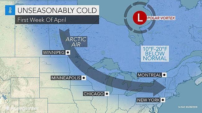
The National Weather Service has already issued a “Hazardous Weather Outlook” for Fairfield, New Haven, Middlesex and New London counties for Saturday night into Sunday morning:
“A strong cold front passage Saturday evening will bring unseasonably cold air to the region on very strong northwesterly winds. Wind gusts behind the front of 50 to 60 mph are possible Saturday night into Sunday morning."
Winds up north in Hartford and Tolland counties may gust up to 30 mph.
The Latest Forecast
- Wednesday: Sun and temps in the low-50s
- Thursday: Sun and temps in the 60s, before rain and thunderstorms move in later in the evening
- Friday: Rain and possible thunderstorms with temps around 60 again
- Saturday: Sun and temps near 50 degrees
Late Saturday and early Sunday, there is a chance for snow showers and an even better chance of snow showers Monday into Tuesday, the weather service predicts. Temps remain cold from Sunday through Wednesday of next week, struggling to reach the low 40s.
Latest Details on Seeing Snow Again This Spring
NBC Connecticut Meteorologist Ryan Hanrahan predicts Thursday and Sunday will be gusty, from 45 to 50 mph on average.
"On Sunday, we will see strong winds over 50 mph along with cold temperatures, clouds, and snow showers," he said. "Sounds like a lovely April day."
NBC Connecticut Meteorologist Darren Sweeney wrote:
“Yesterday's post garnered a lot of attention because I mentioned a big time shot of cold over the weekend and the mention of snow.
Today, the thought process remains the same. Colder air rushes in on Saturday along with a vigorous area of low pressure moving through northern New England. Accumulating snow for them, snow showers for us Saturday night into Sunday morning.
Then... some model data points to another area of low pressure later Monday bringing another chance (this could be more substantial) Still a long way to go but something to watch."
WTNH News 8 Meteorologist Gil Simmons said Wednesday will be sunny, with high temperatures in the 50s. Thursday will be warmer, with highs in the 60s.
"Rain expected on Friday and much colder early next week," Simmons said. "Even the risk of a little wet snow by Monday night and Tuesday of next week."
Photo: Accuweather.com
Get more local news delivered straight to your inbox. Sign up for free Patch newsletters and alerts.