Weather
Hurricane Beryl Weakens As It Nears Jamaica, FL Eyes Storm
Although Hurricane Beryl has weakened, it continues to move across Caribbean waters toward Jamaica as a powerful Category 4 storm.

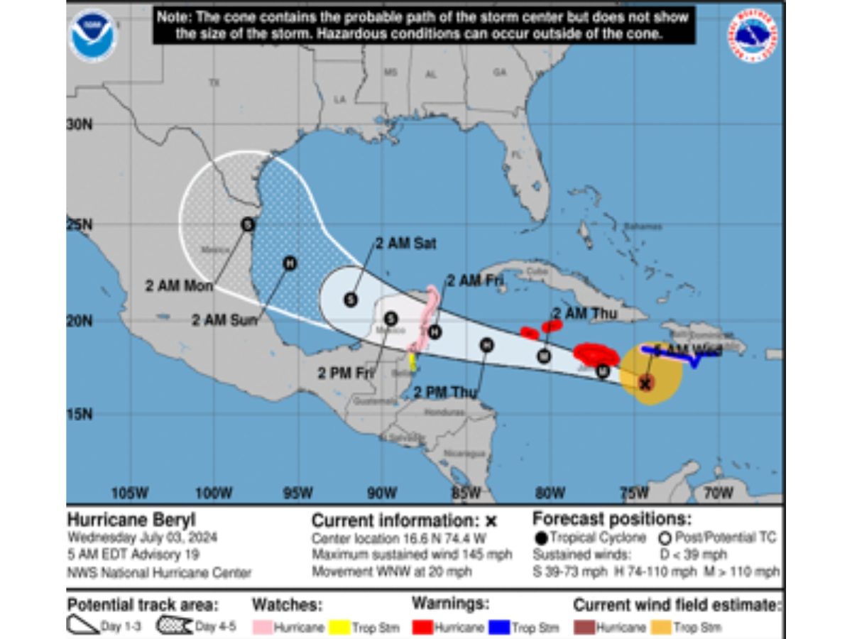
FLORIDA — While Hurricane Beryl weakened late Tuesday, it’s still barreling toward Jamaica as a powerful Category 4 storm after crossing islands in the southeast Caribbean, where it left six people dead, forecasters said.
Late Monday, it became the earliest storm to develop into a Category 5 hurricane in the Atlantic with peak winds of 165 mph.
Boasting 145 mph winds, Beryl’s center was a little over 95 miles southeast of Jamaica’s eastern tip around 9 a.m. Wednesday, Denis Phillips, ABC Action News meteorologist, wrote in a Facebook post.
Find out what's happening in Tampawith free, real-time updates from Patch.
“Hurricane force winds extend up to 45 miles away from the center. Tropical storm winds extend 185 miles away from the center,” Phillips wrote.
Just before 8 a.m., the storm was moving west-northwest at 20 mph, according to the National Hurricane Center.
Find out what's happening in Tampawith free, real-time updates from Patch.
A hurricane warning is in effect for Jamaica, Grand Cayman, Little Cayman and Cayman Brac, while a hurricane watch is in effect for Haiti’s southern coast and the Yucatan Peninsula’s east coast, according to the Associated Press.
By Wednesday afternoon, Beryl is expected to bring “devastating hurricane-force winds, life-threatening storm surge and damaging waves” to Jamaica, NHC said. The Cayman Islands should see effects from the hurricane by early Thursday.
While it will continue to weaken over the next two days, Beryl is expected to remain a hurricane as it approaches Mexico's Yucatan province and Belize Thursday into early Friday. Belize issued a tropical storm watch stretching south from its border with Mexico to Belize City.
Beyond that, there’s uncertainty about Beryl’s track over the western Gulf of Mexico this weekend. Western portions of the Gulf, including parts of Texas, should keep an eye on the storm, NHC said.
“The storm will have another chance to regroup and intensify in the southwestern Gulf before making a final landfall in Mexico or perhaps Texas early next week,” Fox 13’s Paul Dellegatto wrote in a Facebook post.
Though it’s already reached its peak intensity, “Beryl will cause big problems before it finally dissipates over land next week,” he added.
Beryl isn’t expected to have any impact on Florida, Dellegatto said. A ridge of high pressure has protected Florida and the eastern Gulf from the storm. This could bring good news for the Sunshine State.
“The positioning of that ridge during the next few months will go a long way in determining if Florida will have any tropical threats. We are still expecting a very active season,” Dellegatto said.
Though Beryl won’t affect Florida, daily showers and thunderstorms are expected in parts of the state through the weekend.
Here’s the latest weather forecast for the Tampa Bay area from the National Weather Service:
- Wednesday: Scattered showers and thunderstorms, then showers likely and possibly a thunderstorm after 5 p.m. Sunny and hot, with a high near 95. Heat index values as high as 107. Light and variable wind becoming south southwest around 5 mph in the afternoon. Chance of precipitation is 60 percent. New rainfall amounts between a quarter and half of an inch possible.
- Wednesday Night: Showers and thunderstorms likely, mainly before midnight. Partly cloudy, with a low around 77. Northeast wind around 5 mph becoming calm in the evening. Chance of precipitation is 60 percent. New rainfall amounts between a quarter and half of an inch possible.
- Thursday: Isolated showers and thunderstorms, then showers likely and possibly a thunderstorm after 2 p.m. Sunny and hot, with a high near 95. Heat index values as high as 107. Calm wind becoming west 5 to 7 mph in the afternoon. Chance of precipitation is 60 percent. New rainfall amounts of less than a tenth of an inch, except higher amounts possible in thunderstorms.
- Thursday Night: Showers likely and possibly a thunderstorm before 8pm, then scattered showers and thunderstorms between 8 p.m. and 2 a.m. Partly cloudy, with a low around 78. North northwest wind around 5 mph becoming calm in the evening. Chance of precipitation is 60 percent.
- Friday: Scattered showers and thunderstorms after 8 a.m. Mostly sunny, with a high near 94. Calm wind becoming northwest around 5 mph in the afternoon. Chance of precipitation is 50 percent.
- Friday Night: Isolated showers and thunderstorms before 2 a.m. Partly cloudy, with a low around 78. Light and variable wind. Chance of precipitation is 20 percent.
- Saturday: Scattered showers and thunderstorms between 8 a.m. and 2 p.m., then showers likely and possibly a thunderstorm after 2 p.m.. Sunny, with a high near 94. Calm wind becoming west around 6 mph in the afternoon. Chance of precipitation is 60 percent.
- Saturday Night: Showers likely and possibly a thunderstorm before 8 p.m., then isolated showers and thunderstorms between 8 p.m. and 2 a.m. Partly cloudy, with a low around 79. Light west northwest wind. Chance of precipitation is 60 percent.
- Sunday: Scattered showers and thunderstorms between 8 a.m. and 2 p.m., then showers likely and possibly a thunderstorm after 2 p.m. Mostly sunny, with a high near 94. Calm wind becoming southwest around 6 mph in the afternoon. Chance of precipitation is 70 percent.
- Sunday Night: Showers likely and possibly a thunderstorm before 8 p.m., then scattered showers and thunderstorms, mainly between 8 p.m. and 2 a.m. Partly cloudy, with a low around 79. Chance of precipitation is 60 percent.
This article includes reported from The Associated Press.
Get more local news delivered straight to your inbox. Sign up for free Patch newsletters and alerts.