Weather
Tropical Storm Isaias Aims For Maryland
Up to 6 inches of rain and 75 mph wind gusts are possible with Tropical Storm Isaias in Maryland, weather officials warn.


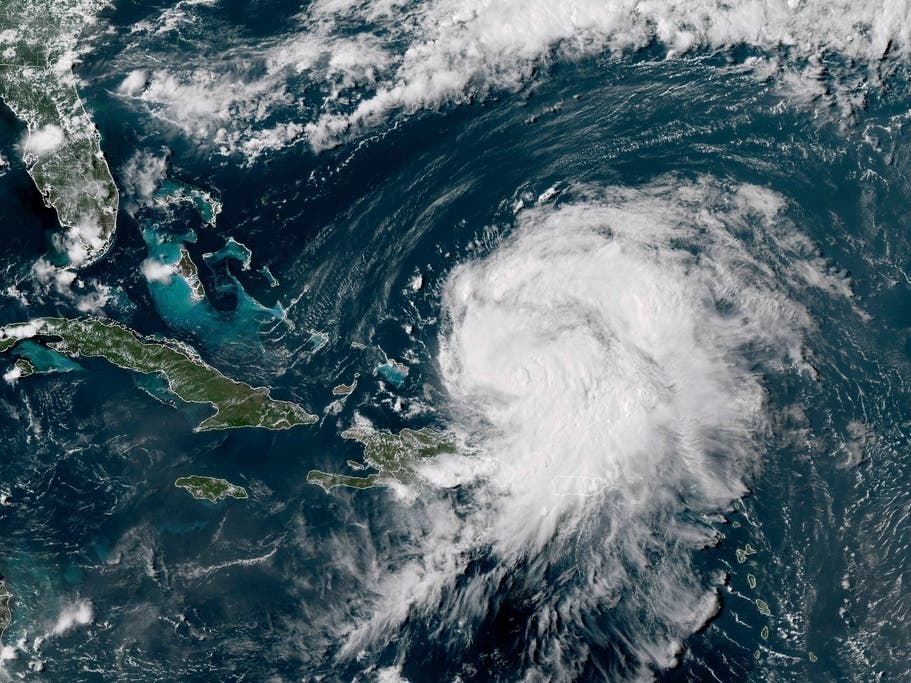
BALTIMORE, MD — As Tropical Storm Isaias picks up speed in the Atlantic, much of Maryland is under a tropical storm warning, and emergency management officials urged residents to prepare. Forecasters said extensive flood damage is anticipated in Maryland, while wind damage may also occur.
Tropical Storm Isaias was about 180 miles south of Washington, D.C., or 210 miles south-southwest of Baltimore, after 5:30 a.m. Tuesday. Packing 70 mph winds, the storm was moving north-northeast at 28 mph.
"Be prepared for potential power outages, flash floods and tidal flooding," Russ Strickland, executive director for the Maryland Emergency Management Agency (MEMA), said in a statement.
Find out what's happening in Havre de Gracewith free, real-time updates from Patch.
As of 8 a.m. Monday, MEMA reported 8,044 were without power across the state.
BGE said crews from sister company ComEd in Chicago are headed east to bolster work to restore power to customers.
Find out what's happening in Havre de Gracewith free, real-time updates from Patch.
At 11:10 p.m. Monday the National Hurricane Center said the storm made landfall near Ocean Isle Beach, North Carolina, with estimated maximum sustained winds at 85 miles per hour. Isaias is expected to produce dangerous winds and storm surge as the category 1 hurricane passes over the state.
As it moves north, the system could bring strong winds and heavy rain to Maryland, D.C. and Virginia.
“Our state is taking every precaution to prepare for the effects of Tropical Storm Isaias—which could include heavy rain, damaging winds, and flash flooding—and I urge all Marylanders to do the same,” said Gov. Larry Hogan. “Stay tuned to your local news stations for the latest updates, listen to state and local authorities, and most importantly, plan and prepare.”
Wind gusts may reach 75 mph in Annapolis and up to 50 mph in Baltimore, according to the National Weather Service, which is calling for about 40 mph sustained winds to blow through the region Tuesday morning through Tuesday afternoon during the tropical storm warning period.
Flash flooding is also a major concern, with 3 to 6 inches of rain or more expected to fall between Monday night and Tuesday evening in Maryland. Residents are advised to begin preparing for extensive flood damage and some wind damage now. The threat is highest along and east of the Interstate 95 corridor.
Parking lots, streets, ditches, creeks and small streams could turn into dangerous rivers, according to the National Weather Service. Underpasses may be submerged. Roads and bridges may become impassable, weak or washed out.
In Howard County, officials said they were inspecting channels in the Ellicott City watershed and removing debris as necessary. Baltimore City and Annapolis distributed sandbags to residents to protect against flooding, which is expected around the Chesapeake Bay and flood-prone areas.
Calvert, Caroline, Dorchester, St. Mary's and Wicomico counties are under a tropical storm warning, which calls for wind gusts up to 80 mph Tuesday morning until Tuesday afternoon. There is a chance of tornadoes around Ocean City as well as in southern Maryland, according to the warning.
Marylanders should ensure to pack at least two face coverings for each person as well as hand sanitizer and disinfectants in their disaster supply kit, according to MEMA.
According to MEMA, central Maryland will be affected, and the lower Eastern Shore and southern Maryland will be the hardest hit. If the storm makes a slight shift west, it could bring heavy rain to parts of western Maryland, officials say, advising most Marylanders will likely feel some effects from Isaias.
"Major rainfall flooding may prompt many evacuations and rescues," according to the tropical storm warning for the Baltimore-Washington region.
Floodwaters may rush into structures, leaving them uninhabitable or gone altogether, the tropical storm warning states. Flood control systems and barriers could become overwhelmed, officials caution. Runoff in mountainous areas may lead to mudslides.
Anne Arundel, Baltimore, Calvert, Carroll, Cecil, Charles, Harford, Montgomery, Prince George's and St. Mary's counties as well as Baltimore City and the District of Columbia are under a tropical storm warning.
Before the storm arrives, people in these areas should prepare, officials say.
Cancellations/Closures
Baltimore City canceled trash and recycling pickup Tuesday. and closed several roads.
Baltimore County canceled meal distribution efforts through the public schools Tuesday.
Calvert County Parks & Recreation facilities/programs are closed/canceled until further notice.
Howard County canceled trash and recycling service Tuesday.
More than a dozen coronavirus testing sites have closed operations Tuesday.
Flash Flood Watch Starts Monday Night
The National Weather Service issued a flash flood watch for parts of Maryland as the East Coast braces for Isaias. Forecasters say the storm is "likely to result in significant flash flooding" around small streams and creeks in Maryland.
Widespread heavy rain is expected to start late Monday night then spread north through Tuesday night.
About 3 to 6 inches of rain may fall across the state, according to the flash flood watch, which says locally higher amounts are possible.
These areas are included in the flash flood watch, effective from 11 p.m. Monday to 11 p.m. Tuesday: Anne Arundel, Baltimore, Calvert, Carroll, Charles, Frederick, Harford, Howard, Montgomery, Prince George's, St. Mary's and Washington counties. Baltimore, D.C. and parts of Virginia are also under the flash flood watch.
Flooding rain may cause extensive damage, according to the watch. Those who live in flood-prone areas are encouraged to prepare and take protective actions.
Coastal Flood Watch Issued For Some Areas
A coastal flood watch takes effect Tuesday morning through evening, especially around high tide, as Tropical Storm Isaias makes its closest approach, according to the National Weather Service.
The coastal flood watch applies to parts of central, northern and southern Maryland and central and northern Virginia as well as the District of Columbia.
Wind Damage Likely In Southern Maryland
In the Baltimore metro area, with 39 to 57 mph winds possible, there is limited risk from wind, according to the National Weather Service.
The wind may cause the most significant impact in southern Maryland, forecasters say, with porches and siding, windows, mobile homes, trees and fences at risk of damage.
Roads may become impassable, and scattered power outages are possible in areas with above-ground lines.
Trees may be uprooted, limbs may snap, and driving could become hazardous on bridges and other elevated roads.
Beach erosion is forecast to be moderate, with strong rip currents and minor to moderate damage to marinas, docks, boardwalks and piers. Some small boats may break free from their moorings, according to forecasters.
Storm surge could be up to 2 feet in surge-prone areas, from early Tuesday morning until early Wednesday morning. Other areas may see 1 foot of storm surge above ground that could cause moderate beach erosion and surge water to cover roads.
See Also:
Get more local news delivered straight to your inbox. Sign up for free Patch newsletters and alerts.