Weather
How Much Snow Will NJ Get? Latest Estimates Released
Another round of snow is expected to hit New Jersey this weekend, with coastal flooding and strong wind gusts in the latest forecast.

NEW JERSEY — Another round of snow is expected to hit New Jersey this weekend, with coastal flooding and strong wind gusts included in the latest forecast.
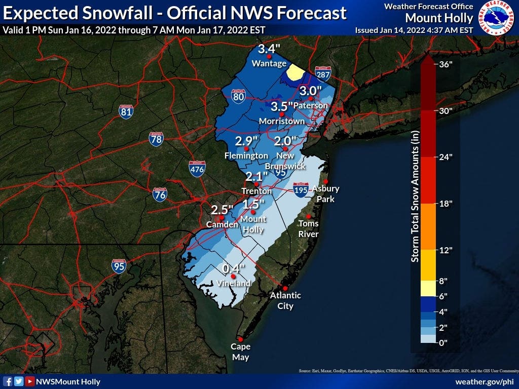
According to the National Weather Service, 1 to 3 inches of snow is expected to fall along I-95 and 3 to 4 inches in areas further northwest. The accumulating snow could mix with sleet before turning to rain on Sunday night.
The weather service’s New York office, which covers Bergen, Essex, Hudson, Passaic and Union counties, said a part of western Passaic County could get 6 to 8 inches of snow. Other areas in Passaic as well as a section of western Bergen are in the 4-to-6-inch range, the weather service said. Essex and Hudson counties are expected to receive 1 to 3 inches of snow.
Find out what's happening in Barnegat-Manahawkinwith free, real-time updates from Patch.
Similarly, AccuWeather's forecast for Sunday is calling for 1 to 3 inches of snow across most of the state with 3 to 6 inches expected in the northwestern part of New Jersey.
Find out what's happening in Barnegat-Manahawkinwith free, real-time updates from Patch.
AccuWeather meteorologists said a subtle shift off the coast could mean more snow for the Garden State.
"Should the storm manage to drift 50 miles or so off the coast while heading northward, I-95 cities from Washington, D.C., to Philadelphia, New York City and Boston could be buried in snow with little or no rain and ice mixing in," AccuWeather Senior Meteorologist Bill Deger said. The greatest threat for damaging winds remains near the Jersey Shore. Gusty north winds will develop throughout the day Friday speeding up to 30 mph.
Periods of coastal flooding are possible with this storm, though the storm will be moving across New Jersey quickly, the weather service said. Forecasters said rain should stop by early Monday afternoon.
.jpg)
Before the winter storm arrives Sunday night, the weather service warns that dangerously cold conditions are expected Friday night through Saturday.
Daytime temperatures will be seasonable on Friday before falling into the teens and single digits overnight with wind chills ranging from zero degrees to -20 degrees through Saturday morning.
Here’s the latest forecast:
Friday: Cloudy, then gradually becoming mostly sunny, with a high near 44. Breezy, with a north wind 15 to 25 mph, with gusts as high as 35 mph.
Friday Night: Mostly clear, with a low around 12. Wind chill values as low as -5. Blustery, with a northwest wind 15 to 25 mph, with gusts as high as 35 mph.
Saturday: Increasing clouds, with a high near 25. Wind chill values as low as -4. North wind 10 to 15 mph.
Saturday Night: Mostly cloudy, with a low around 11. Wind chill values as low as zero. North wind 5 to 10 mph.
Sunday: A chance of rain and snow after 4 p.m. Partly sunny, with a high near 40. Northeast wind 5 to 15 mph becoming east in the afternoon. Chance of precipitation is 30 percent. Little or no snow accumulation expected.
Sunday Night: A chance of rain and snow before 7 p.m., then rain. Low around 37. Windy. Chance of precipitation is 90 percent. New precipitation amounts between 1 and 2 inches possible.
Get more local news delivered straight to your inbox. Sign up for free Patch newsletters and alerts.


