Weather
Debby In Haddonfield, Haddon Twp.: Tornadoes, Floods, Heavy Rain Possible
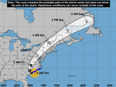
Tropical Storm Debby made its 2nd landfall down south on Thursday. Here's how the storm could impact Haddon Township and Haddonfield.

HADDONFIELD, NJ — Tropical Storm Debby could bring tornadoes and severe thunderstorms to the region, just days after flash floods hit Haddonfield and Haddon Township, according to weather officials.
The potential for heavy rain and flash flooding will continue through Friday, the National Weather Service's (NWS) regional office said Thursday morning in a storm briefing. Localized flash flooding is possible throughout the Mid-Atlantic on Thursday, but Debby's most-significant local impacts will likely fall on Friday.
Tornadoes represent Debby's greatest potential local threat. There's a marginal (1 in 5) risk of severe storms with tornadoes developing in the region throughout Friday, according to the NWS's Philadelphia/Mount Holly Office, which covers most of New Jersey.
Find out what's happening in Haddonfield-Haddon Townshipwith free, real-time updates from Patch.
Debby made a second landfall Thursday in South Carolina. It is a tropical storm as of Thursday morning, sustaining 50 mph winds.
The storm's magnitude in the region will depend on Debby's track. But the storm is expected to move inland, reducing New Jersey's chances of tornadoes, the NWS said. The areas north and west of Interstate 95 have a greater risk of severe impacts, according to weather officials.
Find out what's happening in Haddonfield-Haddon Townshipwith free, real-time updates from Patch.
The NWS expects 1 to 1.5 inches of rain in the Haddonfield area through Friday night.

River flooding could develop Friday and linger into Saturday, officials said.
Heavy rain fell in the area earlier this week, flooding several streets in Haddonfield. PATCO temporarily suspended service at the Haddonfield and Westmont stations, with substitute buses unable to reach either stations because of flooding.
Here's the NWS's latest local forecast:
- Thursday: Showers likely and possibly a thunderstorm. Mostly cloudy, with a high near 78. East wind around 10 mph. Chance of precipitation is 60 percent. New rainfall amounts between a quarter and half of an inch possible.
- Thursday night: Scattered showers and thunderstorms, then showers likely and possibly a thunderstorm after 4 a.m. Mostly cloudy, with a low around 73. East wind 5 to 10 mph. Chance of precipitation is 60 percent. New rainfall amounts between a tenth and quarter of an inch, except higher amounts possible in thunderstorms.
- Friday: Showers and possibly a thunderstorm. Some of the storms could produce heavy rainfall. High near 82. Breezy, with a south wind 15 to 20 mph, with gusts as high as 35 mph. Chance of precipitation is 90 percent. New rainfall amounts between a quarter and half of an inch possible.
- Friday night: Showers and possibly a thunderstorm before 2 a.m., then a chance of showers and thunderstorms after 2 a.m. Low around 73. South wind around 15 mph, with gusts as high as 30 mph. Chance of precipitation is 80 percent. New rainfall amounts between a quarter and half of an inch possible.
- Saturday: A chance of showers before 8 a.m. Sunny, with a high near 84. West wind around 10 mph. Chance of precipitation is 30 percent. New precipitation amounts of less than a tenth of an inch possible.
Get more local news delivered straight to your inbox. Sign up for free Patch newsletters and alerts.


