Home & Garden
Hurricane Hermine Has Formed: How It Will Affect Long Island
How much rain will we get? It could be a lot or a little depending on Hurricane Hermine's track, forecasters say.

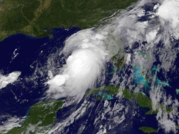
You might have to say goodbye to perfect weather and beach days this Labor Day weekend: Hurricane Hermine (pronounced "her-mean") has officially formed.
As of 3:15 p.m. Thursday, Hurricane Hermine is 12 hours from landfall along Flordia’s Gulf Coast.
On its present track, Hurricane Hermine is expected to cut across northern Florida Friday before heading toward Georgia and South Carolina. The storm is anticipated to then move through parts of North Carolina early Saturday morning before continuing in a northeasterly direction that could bring it in contact with northern coastal states late in the weekend.
Find out what's happening in Port Washingtonwith free, real-time updates from Patch.
Hurricane Hermine and Long Island
As the storm moves, NWS forecast believes Hurricane Hermine will impact Long Island and the rest of the eastern seaboard this Labor Day weekend into Tuesday.
The big question is: Wow much rain will we get?
Answer: It depends.
Coastal flooding, heavy rain and strong winds are likely depending on the storm’s exact track and strength, the NWS says. A flash flood warning and a flood advisory was issued for parts of Long Island on Thursday afternoon as the storm approaches.
Find out what's happening in Port Washingtonwith free, real-time updates from Patch.
A NWS forecast discussion said the heaviest rain will occur offshore and rain on land is an uncertainty.
“Despite the close proximity, the only areas that may see heavy rainfall may be the Twin Forks of Long Island, as they will be closer to the low than the rest of the area,” the NWS said in a forecast discussion Thursday afternoon.
The NWS says there will be a chance of rain and gusty winds in the region beginning late day Saturday, continuing into Sunday and then tapering off on Monday.
ABC's local NYC station reported: "Meteorologist Lee Goldberg said if the storm stays over land, it will weaken by the time it reaches our region, but it will still be a significant event. In this scenario, we could expect Nor'easter-like weather, with a lot of rain and wind."
There’s a high risk for rip currents and beach erosion this weekend and into early next week. Even if Hermine doesn't hit directly, the NWS has warned Long Island residents and beach-goers to be cautious while the storm's nearby: a Brooklyn man drowned at a Long Island beach on Monday night.
Hurricane Hermine's initial development occurred during the start of the Atlantic Hurricane Season’s traditional peak. The season peaks each year between mid-August and mid-October. The period is described as the “season within the season” by forecasters. This eight-week period “is often the most active and dangerous time for tropical cyclone activity,” NOAA explained on its website.
The eight-week period is historically responsible for major spikes in tropical weather activity, NOAA said. In fact, it accounts for about 78 percent of all tropical storm days on record. It is also the period when 87 percent of the Category 1 and 2 hurricane days on record occurred. In addition, this period is responsible for “a whopping 96 percent of the major (Category 3, 4 and 5) hurricane days.”
As hurricane season’s peak continues, emergency management officials urge residents in coastal areas to be prepared.
To find out more about hurricane season and storm preparation, read these related Patch stories:
- Hurricane Season 2016: Where To Find Local Information
- 2016 Atlantic Hurricane Season Forecast Released
- Hurricane Season: How to Prepare
- 2016 Hurricane Names: Is Yours On the List?
To keep up with storm activity as the season develops, bookmark the National Hurricane Center’s website and keep an eye on your hometown Patch site for local information.
Images courtesy of the National Hurricane Center
Reporting by Sheri Lonon and Ryan Bonner
Get more local news delivered straight to your inbox. Sign up for free Patch newsletters and alerts.