Weather
Tropical Storm Debby: Latest Forecast For PA Impacts
Here's what forecasters are saying about Debby, its timing and how the tropical air will put a damper on the weather throughout the week.

PHILADELPHIA, PA — Severe storms and flooding are possible throughout the Philadelphia region through the weekend, forecasters with the National Weather said in a new briefing released Tuesday morning. The unsettled weather is fueled by tropical air that is on the periphery of Debby, AccuWeather forecasters said.
Debby, which made landfall as a Category 1 hurricane earlier this week, is predicted to clear the Georgia coast sometime Tuesday and move offshore before moving inland once again. Early estimates are that the remnants of the storm will pass over the Philadelphia region sometime during the weekend — likely Saturday.
However, the impacts from the storm will be felt before the weekend.
Find out what's happening in Across Pennsylvaniawith free, real-time updates from Patch.
"Tropical air from the periphery of Debby's influence will push up into the frontal zone from Tuesday to Wednesday, adding water to the air that will, in turn, be squeezed out," AccuWeather Senior Meteorologist Dave Dombek explained. "This will enhance the downpours and correspondingly raise rainfall amounts to a higher level than if there had been no tropical moisture in the first place."
Storms, some of which could be severe, are possible in Eastern Pennsylvania Tuesday afternoon and night. A flood watch has been issued across the region; it runs through noon on Wednesday.
Find out what's happening in Across Pennsylvaniawith free, real-time updates from Patch.
Tuesday's storms have the risk of damaging downburst wind gusts that could down trees and power lines. Small hail is also possible.

Downpours and flash flooding are also in the forecast through Wednesday morning. Chances for heavy rain could continue Wednesday into Thursday, the National Weather Service said. The risk of storms and unsettled weather goes through the weekend.
Then, over the weekend, the storm is expected to pass through the area.
"Tropical Storm Debby will meander across parts of the Southeastern U.S. most of this week. Direct impacts on the MidAtlantic area are likely by the end of this week into the weekend," the Weather Service said, adding there is "still high uncertainty with the details to our area."
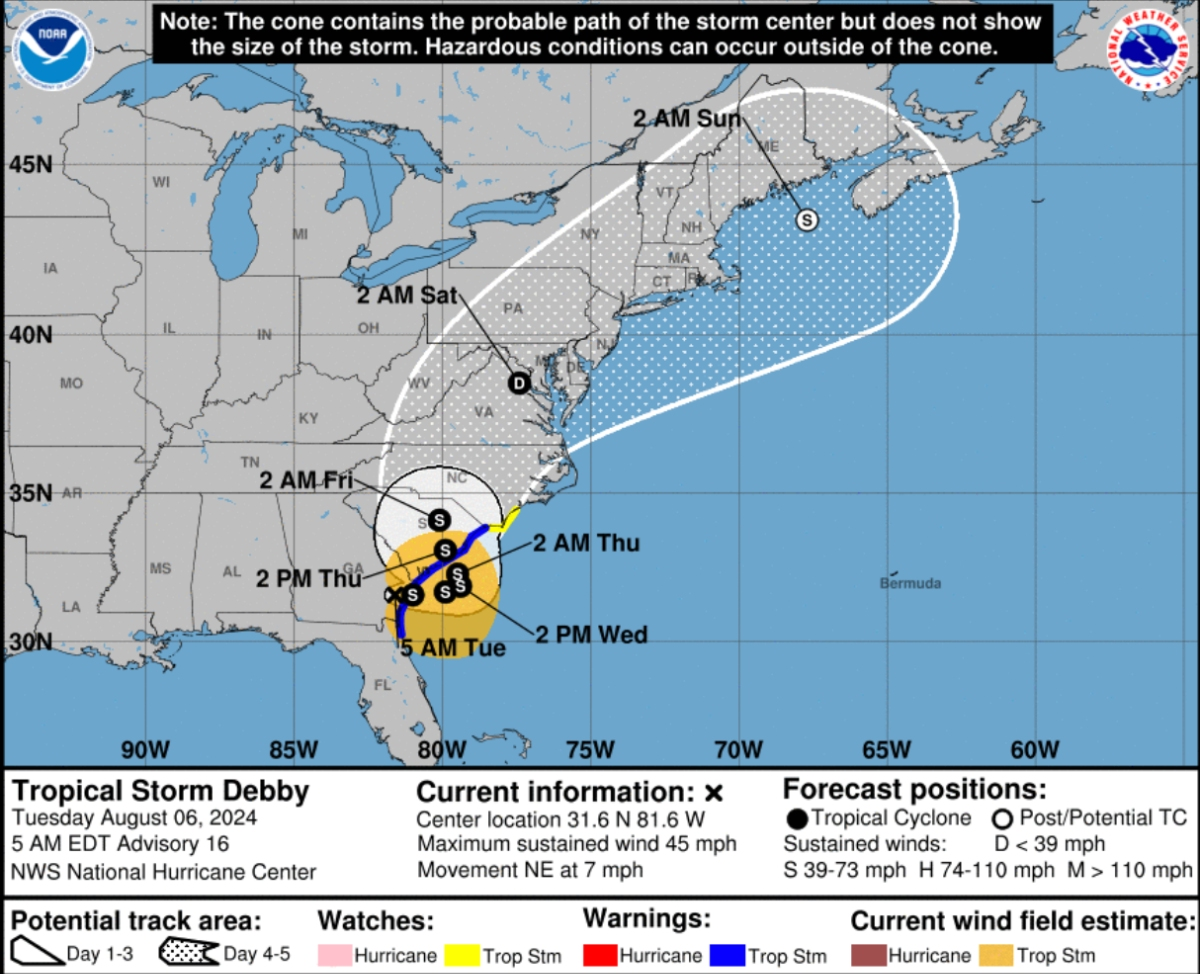
This newly released track shows the current timing of the storm:

Here is the local forecast:
Today: A chance of showers and thunderstorms between noon and 2 pm, then showers likely and possibly a thunderstorm after 2 pm. Increasing clouds, with a high near 92. Southwest wind 5 to 10 mph. Chance of precipitation is 70%. New rainfall amounts between a quarter and half of an inch possible.
Tonight: Showers and possibly a thunderstorm. Some of the storms could produce heavy rainfall. Low around 70. Southeast wind around 5 mph becoming northwest after midnight. Chance of precipitation is 90%. New rainfall amounts between 1 and 2 inches possible.
Wednesday: Showers and possibly a thunderstorm. Some of the storms could produce heavy rainfall. High near 77. Northeast wind 5 to 10 mph. Chance of precipitation is 80%. New rainfall amounts between a quarter and half of an inch possible.
Wednesday night: A chance of showers and thunderstorms. Mostly cloudy, with a low around 66. Northeast wind around 5 mph. Chance of precipitation is 50%. New rainfall amounts between a tenth and quarter of an inch, except higher amounts possible in thunderstorms.
Thursday: A chance of showers and thunderstorms before 8 am, then a chance of showers between 8 am and 2 pm, then showers likely and possibly a thunderstorm after 2 pm. Mostly cloudy, with a high near 76. East wind around 10 mph. Chance of precipitation is 60%. New rainfall amounts between a quarter and half of an inch possible.
Thursday Night: Showers and possibly a thunderstorm. Low around 69. Chance of precipitation is 80%. New rainfall amounts between a quarter and half of an inch possible.
Friday: Showers and possibly a thunderstorm. High near 80. Chance of precipitation is 90%.
Friday Night: Showers likely and possibly a thunderstorm. Mostly cloudy, with a low around 72. Chance of precipitation is 70%.
Saturday: Showers likely and possibly a thunderstorm before 2pm, then a chance of showers. Partly sunny, with a high near 82. Chance of precipitation is 60%.
Saturday Night
A chance of showers before 2am. Partly cloudy, with a low around 64. Chance of precipitation is 30%.
Get more local news delivered straight to your inbox. Sign up for free Patch newsletters and alerts.


