Weather
Tropical Storm Debby: Latest Forecast For VA Impacts
An incoming cold front combined with the remnants of Tropical Storm Debby could bring multiple inches of rain and flash flooding to NoVA.

VIRGINIA — Virginians should enjoy one final day of sunny skies Tuesday before a cold front from the north and the remnants of Tropical Storm Debby bring multiple days of heavy rainfall and storms to the state.
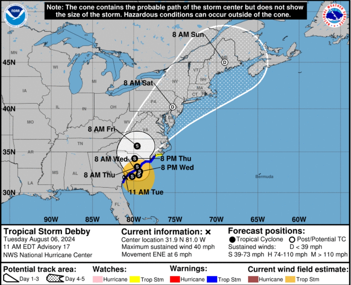
A hazardous weather outlook is in effect for the northern part of the state as Tropical Storm Debby was forecast to move inland over South Carolina on Thursday and track slowly northeastward across eastern North Carolina and Virginia later this week, the National Weather Service said in its latest forecast.
Combined with the incoming cold front, Virginians could see scattered showers and thunderstorms starting Tuesday night and continuing through Saturday, forecasters said. Some parts of the state could see more than 3 inches of rain, according to the Capital Weather Gang.
Find out what's happening in Old Town Alexandriawith free, real-time updates from Patch.
"Rains may exceed our typical average for all of August of 3.25 inches, which could threaten areas of localized flooding, but also help with the drought conditions that are especially persisting west of D.C.," the Capital Weather Gang said in its latest forecast.
On Tuesday, Tropical Storm Debby moved menacingly into some of America’s most historic Southern cities, bringing prolonged downpours and flooding after slamming into Florida and prompting the rescue of hundreds from flooded homes.
Find out what's happening in Old Town Alexandriawith free, real-time updates from Patch.
Record-setting rain from the storm that killed at least five people in Florida and Georgia was causing flash flooding, with up to 25 inches possible in some areas, the National Hurricane Center said in its latest advisory Tuesday morning.
The storm’s center was just southwest of Savannah early Tuesday with maximum sustained winds near 45 mph and it was moving northeast at less than 6 mph.
Debby is expected to continue moving up the East Coast and is likely to bring heavy rainfall from North Carolina through portions of the mid-Atlantic states and southern New England through Sunday morning, NHC forecasters said.
In Virginia, isolated severe thunderstorms are possible Tuesday afternoon and evening, mainly along and north of US Route 50, according to the NWS.
The main threat with Tuesday's storms is damaging wind gusts. There's also a slight chance of flash flooding in the D.C. metro area, forecasters said.
Debby will approach the region later this week, bringing heavy rainfall and possible flooding Thursday into Saturday. The system will likely become a tropical depression by Friday before passing over the Delmarva Peninsula and off the coast for the weekend, forecasters said.
"Friday may be our wettest day as Debby’s remnant low-pressure center makes its closest pass," the Capital Weather Gang said in its forecast.
Dry conditions should return to the region by Sunday and will be accompanied by mostly sunny skies, very low humidity and highs in the low-to-mid 80s.
Here's the latest NWS forecast through this weekend:
Tuesday: Mostly sunny, with a high near 96. Heat index values as high as 105. South wind around 10 mph, with gusts as high as 21 mph.
Tuesday Night: A chance of showers and thunderstorms, mainly between 9pm and 1am. Mostly cloudy, with a low around 75. South wind around 10 mph, with gusts as high as 22 mph. Chance of precipitation is 30%.
Wednesday: Showers likely and possibly a thunderstorm before 5pm, then showers and thunderstorms likely after 5pm. Mostly cloudy, with a high near 87. South wind 6 to 9 mph becoming east in the afternoon. Chance of precipitation is 70%. New rainfall amounts between a tenth and quarter of an inch, except higher amounts possible in thunderstorms.
Wednesday Night: Showers and thunderstorms likely before 11pm, then showers likely and possibly a thunderstorm after 11pm. Cloudy, with a low around 72. Northeast wind around 9 mph. Chance of precipitation is 70%. New rainfall amounts between a tenth and quarter of an inch, except higher amounts possible in thunderstorms.
Thursday: Showers likely and possibly a thunderstorm. Cloudy, with a high near 81. East wind 11 to 13 mph, with gusts as high as 22 mph. Chance of precipitation is 70%.
Thursday Night: Showers and possibly a thunderstorm. Low around 74. Chance of precipitation is 80%.
Friday: Showers, with thunderstorms also possible after 2pm. High near 85. Chance of precipitation is 80%.
Friday Night: Showers and possibly a thunderstorm, mainly before 2am, then a chance of showers and thunderstorms after 2am. Low around 74. Chance of precipitation is 80%.
Saturday: A chance of showers. Mostly sunny, with a high near 86. Chance of precipitation is 40%.
Saturday Night: Mostly clear, with a low around 65.
Sunday: Sunny, with a high near 84.
Sunday Night: Mostly clear, with a low around 65.
Get more local news delivered straight to your inbox. Sign up for free Patch newsletters and alerts.


