Weather
'Hazardous Weather' Alert Issued For SE Wisconsin
A hazardous weather outlook has been issued this afternoon for much of eastern Wisconsin Wednesday afternoon.

MILWAUKEE — A hazardous weather outlook has been issued this afternoon for much of eastern Wisconsin, including Marquette, Green Lake, Fond du Lac, Sheboygan, Sauk, Columbia, Dodge, Washington, Ozaukee, Iowa, Dane, Jefferson, Waukesha, Milwaukee, Lafayette, Green, Rock, Walworth, Racine, Kenosha.
"There is a chance for thunderstorms after midnight with a few storms potentially being strong. Hail and damaging winds are the main potential hazards," the National Weather Service said.
"Heat indices will be just below advisory levels into the early evening."
Find out what's happening in Milwaukeewith free, real-time updates from Patch.
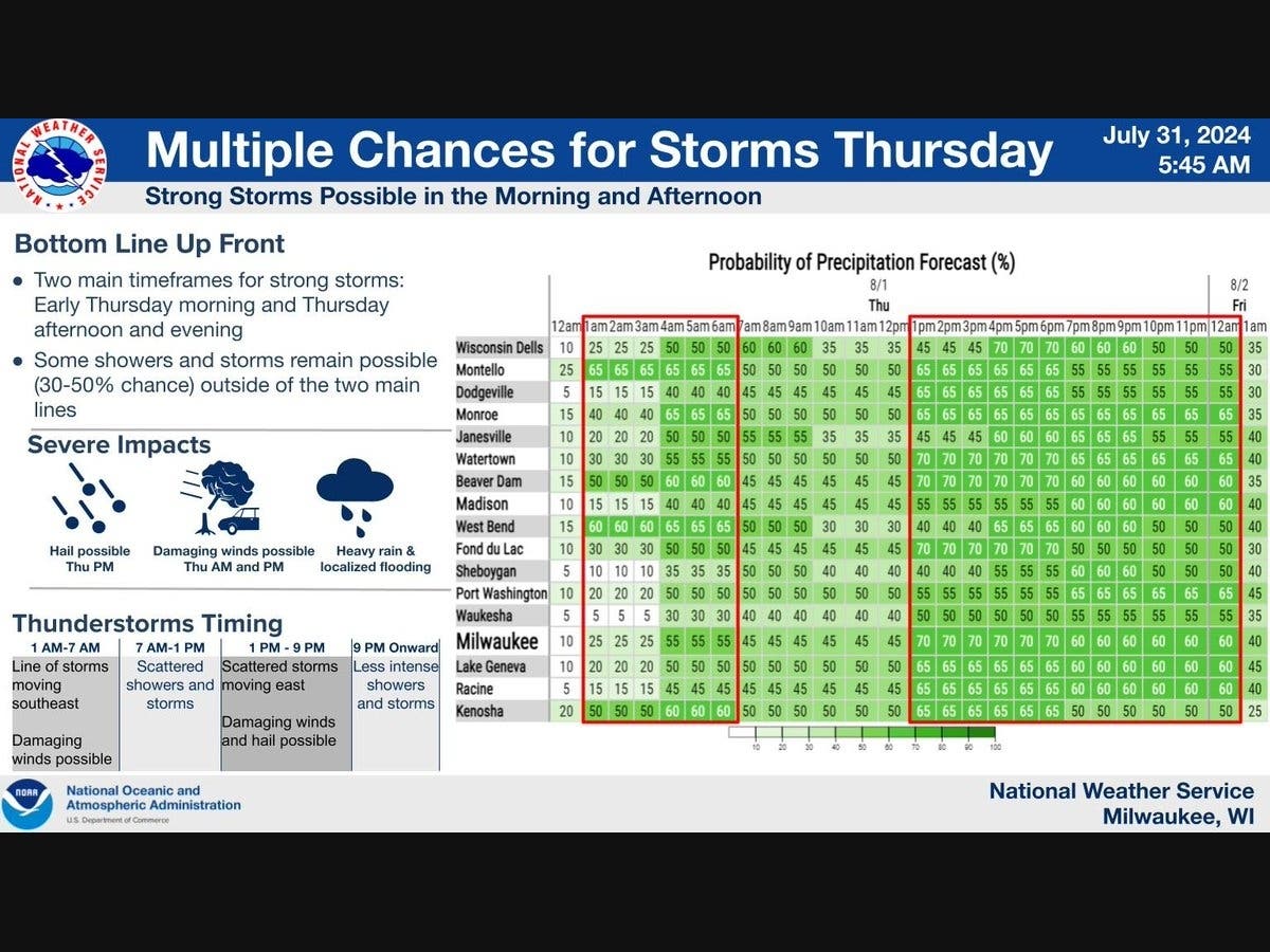
Here's the full NWS forecast from the Milwaukee Airport:
Tonight: A chance of showers and thunderstorms, then showers likely and possibly a thunderstorm after 5am. Increasing clouds, with a low around 71. North wind around 5 mph becoming calm in the evening. Chance of precipitation is 60%. New rainfall amounts of less than a tenth of an inch, except higher amounts possible in thunderstorms.
Find out what's happening in Milwaukeewith free, real-time updates from Patch.
Thursday: A 50 percent chance of showers and thunderstorms. Mostly cloudy, with a high near 86. East wind 5 to 10 mph.
Thursday Night: Showers and thunderstorms likely, mainly before 1am. Mostly cloudy, with a low around 69. East wind around 5 mph becoming north after midnight. Chance of precipitation is 60%. New rainfall amounts between a quarter and half of an inch possible.
Friday: A 30 percent chance of showers and thunderstorms before 1pm. Partly sunny, with a high near 83. North wind 5 to 10 mph.
Friday Night: Mostly clear, with a low around 68. North wind around 5 mph.
Saturday: Sunny, with a high near 89. North wind 5 to 10 mph.
Saturday Night: Mostly clear, with a low around 69. Northeast wind around 5 mph becoming calm in the evening.
Sunday: A 20 percent chance of showers and thunderstorms after 1pm. Mostly sunny, with a high near 85. West wind 5 to 10 mph.
Sunday Night: A 20 percent chance of showers and thunderstorms after 1am. Mostly cloudy, with a low around 65.
Monday: A slight chance of showers and thunderstorms. Partly sunny, with a high near 78. Chance of precipitation is 20%.
Monday Night: A 40 percent chance of showers and thunderstorms. Mostly cloudy, with a low around 64.
Tuesday: A 30 percent chance of showers and thunderstorms. Partly sunny, with a high near 80.
Tuesday Night: A 30 percent chance of showers and thunderstorms. Mostly cloudy, with a low around 62.
Wednesday: A 20 percent chance of showers. Partly sunny, with a high near 77.
Get more local news delivered straight to your inbox. Sign up for free Patch newsletters and alerts.


