RSS 5 Day Weather Outlook
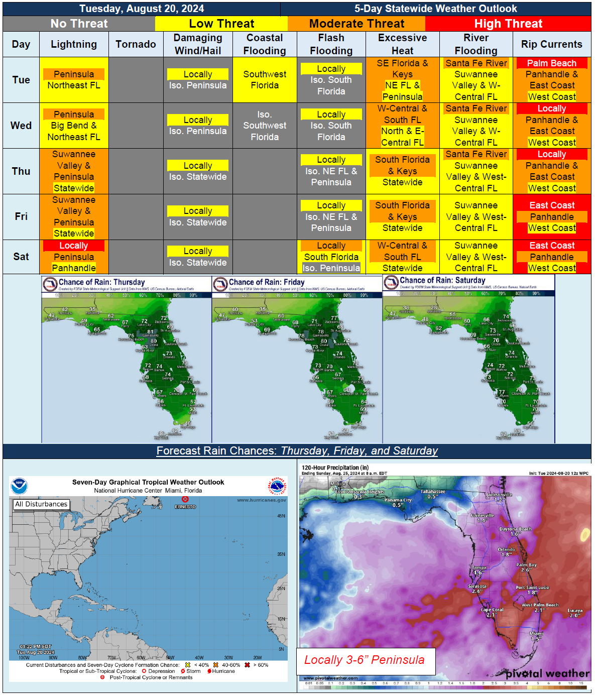
5 Day Statewide Weather Outlook for Tues. 8/20 to Fri. 8/24
You are subscribed to 5 Day Weather Outlook for Florida Division of Emergency Management. This information has recently been updated, and is now available.
…Drier Conditions Return to Panhandle and Western Big Bend Tuesday and Partially Wednesday…Moisture Gradually Increases and Will Bring More Scattered Showers and Thunderstorms through End of Week Across Panhandle and Big Bend…Frontal Boundary Becomes Stationary Along Northern Peninsula for Next Several Days…Scattered to Numerous Showers and Thunderstorms Throughout Afternoon and Evening Hours Across Peninsula…Locally Strong to Severe Thunderstorms Possible At Times…Tropical Wave Bringing Widespread Rainfall Across South Florida Late Friday and Into Saturday…Marginal Risk (Level 1 of 4) for Flash Flooding Across South Florida on Saturday…Minor to Moderate Riverine Flooding To Continue Across Suwannee Valley and West-Central Florida…
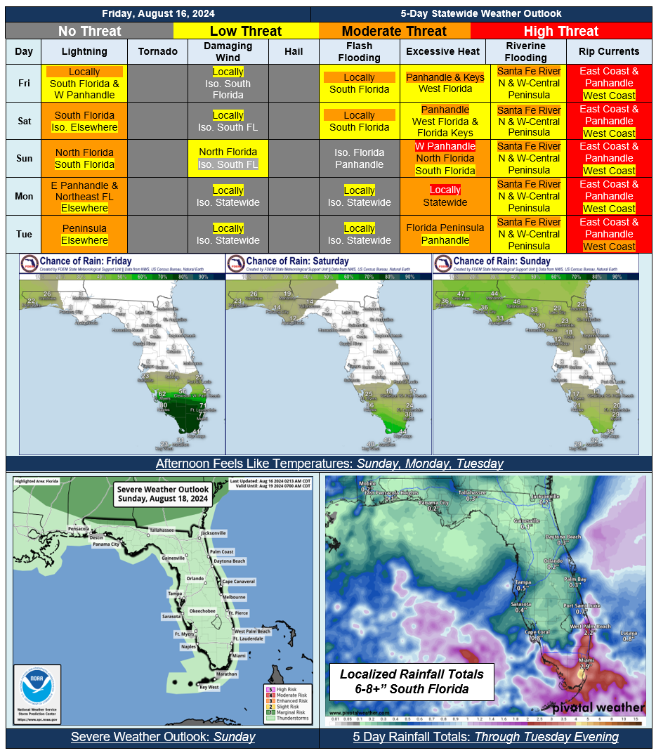
5 Day Statewide Weather Outlook (Fri. 8/16 - Tue. 8/20)
You are subscribed to 5 Day Weather Outlook for Florida Division of Emergency Management. This information has recently been updated, and is now available.
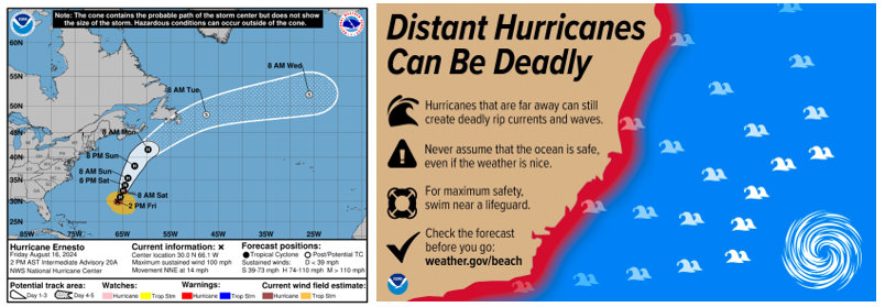
...Distant Ernesto Brings Rough Surf & Dangerous Rip Currents to Florida East Coast Beaches This Weekend…Scattered to Numerous Thunderstorms Capable of Producing Flash & Urban Flooding in Southern Florida Peninsula…Relief from the Heat & Humidity Arriving Overnight…Cold Front Bring Increased Thunderstorm Chances to North Florida Sunday, a Few Thunderstorms May Be Strong to Severe…
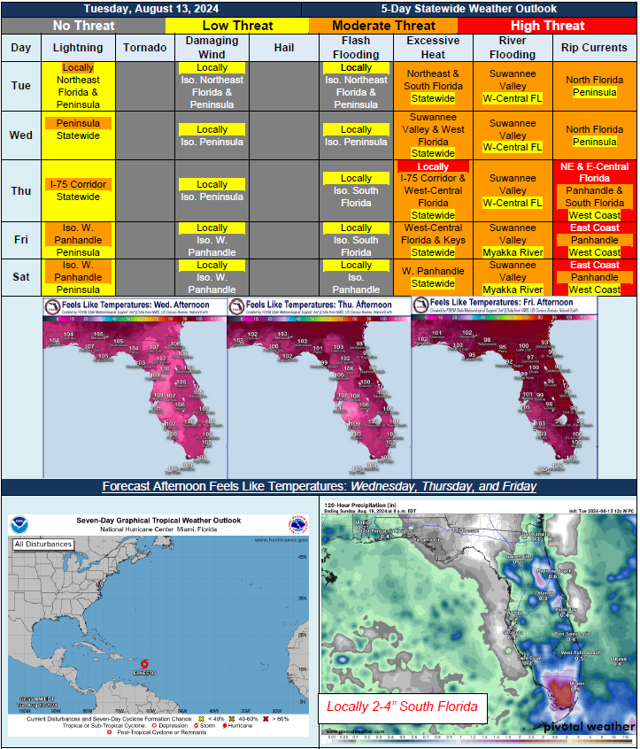
5 Day Statewide Weather Outlook for Tue. 8/13 to Sat. 8/17
You are subscribed to 5 Day Weather Outlook for Florida Division of Emergency Management. This information has recently been updated, and is now available.
…Typical Summertime Pattern Continues With Showers and Thunderstorms Along Sea Breeze Boundary…Hot and Humid Conditions Each Day, Peaking Wednesday and Thursday…Cold Front Moving In from Northeast Later This Week Bringing Drier Conditions…Possible Complex of Thunderstorms Along Panhandle Late Friday or Saturday; High Uncertainty At This Time…Greatest Coverage of Showers and Thunderstorms Across South Florida Later This Week…Minor to Moderate Riverine Flooding Continues Across Big Bend, Suwannee Valley and West-Central Florida; Long-Term River Flooding Forecast for Santa Fe and Suwanee River Basins…Tropical Storm Ernesto To Stay Well East of Florida But Bring Dangerous Rip Currents and Ocean Swells to Beaches Late This Week and Into the Weekend…
5 Day Statewide Weather Outlook for Fri 8/9 to Tue 8/13
You are subscribed to 5 Day Weather Outlook for Florida Division of Emergency Management. This information has recently been updated, and is now available.
...A More Typical Summertime Weather Pattern Returns Statewide With Scattered to Numerous Showers and Thunderstorms Along the Sea Breezes…Frontal Boundary Stalled Along the Florida Panhandle to Bring Additional Showers and Thunderstorms to Portions of North Florida Through the Weekend…Locally Strong to Severe Thunderstorms Producing Frequent Lightning, Gusty Winds, and Heavy Downpours Possible During Peak Heating Hours…Any Additional Rainfall Over Heavily Saturated Grounds May Lead To Further Instances of Flooding or Exacerbate Lingering Flood Conditions…Triple Digit Heat Indices Persist Through the Period; Heat Advisories Likely to Be Issued and Excessive Heat Warnings Cannot Be Ruled Out; Practice Heat Safety…Moderate Risk for Rip Currents to Persist Along Florida Panhandle and Northeast Coast…Numerous River Flood Warnings Across North and West Florida; Minor to Major Flooding Across Suwannee Valley and Northeast Florida; Minor to Moderate Flooding Across West Florida…A Tropical Wave In the Tropical Atlantic Is Producing A Large Area of Disorganized Showers and Thunderstorms; Medium (60%) Chance of Development Through 7 Days…
…Have A Wonderful Weekend!...

5 Day Statewide Weather Outlook for Tue 8/6 to Sat 8/10
You are subscribed to 5 Day Weather Outlook for Florida Division of Emergency Management. This information has recently been updated, and is now available.
…Scattered Showers and Thunderstorms to Persist Along the Peninsula and Into the Big Bend Over the Next 5 Days…Any Additional Rainfall Over Highly Saturated and Flooded Grounds May Lead to Exacerbated Flood Conditions and Additional Instances of Flooding and Ponding of Water; Marginal to Slight Risk for Flash Flooding…Locally Strong to Severe Thunderstorms Cannot Be Ruled Out During Peak Heating Hours….Drier Conditions Along the Florida Panhandle as High Pressure Builds In To the West…Hot and Humid Conditions to Redevelop Statewide Over the Next 5 Days; Heat Advisories Will Likely Be Necessary Across Portions of the state…Breezy Winds to Continue Across Much Of the State With Wind Gusts Upwards of 20-30 MPH At Times Over the Next Few Days…Numerous River Flood Warnings Have Been Issued For Moderate to Major Flooding Along Several Mainstems and Branches, Including the Suwannee, Santa Fe, Manatee, and Myakka Rivers…Hazardous Beach and Boating Conditions Linger Into Mid-to-Late Week as Elevated Surf and Breezy Winds Linger…
…Have a Great Week and Stay Safe!...

