


Editor's note: See the latest Saturday forecast here.
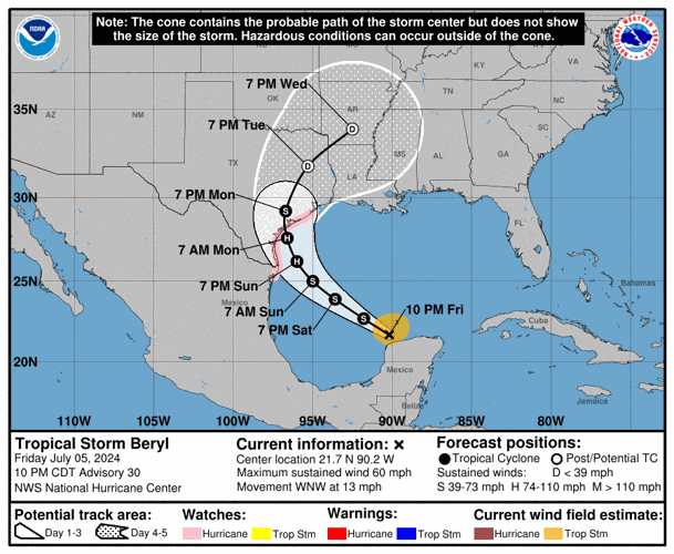
Now-Tropical Storm Beryl's track continued an eastward shift Friday night, putting most of Louisiana, including Baton Rouge, in the forecast cone after it makes landfall and weakens to a tropical depression, the National Hurricane Center said.
The track could keep shifting east over the weekend, and the storm could rapidly intensify just before hitting Texas, the Hurricane Center warned.
While Beryl's structure became tilted as it entered the Gulf of Mexico after crossing the Yucatan Peninsula, with its low-level center southwest of its mid-level vortex, "the overall environmental conditions are conducive for strengthening with increasing water temperatures and decreasing vertical wind shear along the expected track," said Senior Hurricane Specialist John Cangialosi in a 10 p.m. forecast discussion message.

Infrared satellite view of Tropical Storm Beryl moving off the Yucatan Peninsula at just after 10:30 p.m. Friday, July 5. (NOAA)
The storm is expected to re-strengthen into a hurricane with 90 mph winds, a strong Category 1 storm, over the Gulf of Mexico, and make landfall just after 7 a.m. Monday in southeast Texas before curving inland towards Louisiana and Arkansas.
The storm was 615 miles southeast of Corpus Christi at 10 p.m., moving west northwest at 13 mph.
Western and central Louisiana would start seeing some winds from Beryl by Sunday morning.
With the center of the storm curving northeast over Texas, the right side of the storm system would continue lifting moisture from the Gulf across Louisiana through Wednesday, the latest forecast shows. There's a slight, 15% chance of flash flooding over the western half of southern Louisiana and almost all of north Louisiana through Wednesday morning.

Earliest arrival time of tropical-storm-force winds for Beryl as of 10 p.m. Friday
The tropical storm exited the Yucatan Peninsula just after 7 p.m. Friday, where it hit as a Category 2. Now that it's in the Gulf, it will strengthen over the weekend.
The center of the storm could skirt the Texas coast before making landfall farther to the east, near Corpus Christi, on Monday afternoon, the latest cone shows.
Recent model runs, though not skillful at predicting maximum winds, are predicting significant decreases in Beryl's minimum pressure over the next few days, which favors slow strengthening until landfall, Cangialosi said.
Forecasters are warning that much of the Texas coastline, from the mouth of the Rio Grande to High Island and Galveston Bay could see storm surges as high as 5 feet.
Forecasting the track is still very uncertain beyond three days, the Hurricane Center warns, and the forecast can be off by 100 miles that far out.
As the storm gets closer, local National Weather Service offices will issue more specific guidance.

Staff writer Mark Schleifstein contributed to this story.