Tropical Depression 3 formed in the Bay of Campeche at about 4 p.m. Saturday and could strengthen to become Tropical Storm Chris before moving onshore on the Mexico Gulf Coast on Monday morning, according to a 7 p.m. Saturday forecast by the National Hurricane Center.
The storm poses no threat to Louisiana, forecasters say. The hurricane center also is issuing forecast messages for Category 4 Hurricane Beryl, which is expected to reach the Windward Islands in the Caribbean Sea on Monday.
The Mexican government has issued a tropical storm warning for the area of the coast from Cabo Rojo to Puerto Veracruz, meaning tropical storm conditions are expected within the next 12 hours.
![Tropical Depression](https://bloximages.newyork1.vip.townnews.com/nola.com/content/tncms/assets/v3/editorial/d/36/d36de684-8809-5165-a245-9ba8ba6f3c12/6681f3e68c2cb.image.png?crop=748%2C421%2C0%2C121&resize=150%2C84&order=crop%2Cresize 150w, https://bloximages.newyork1.vip.townnews.com/nola.com/content/tncms/assets/v3/editorial/d/36/d36de684-8809-5165-a245-9ba8ba6f3c12/6681f3e68c2cb.image.png?crop=748%2C421%2C0%2C121&resize=200%2C113&order=crop%2Cresize 200w, https://bloximages.newyork1.vip.townnews.com/nola.com/content/tncms/assets/v3/editorial/d/36/d36de684-8809-5165-a245-9ba8ba6f3c12/6681f3e68c2cb.image.png?crop=748%2C421%2C0%2C121&resize=225%2C127&order=crop%2Cresize 225w, https://bloximages.newyork1.vip.townnews.com/nola.com/content/tncms/assets/v3/editorial/d/36/d36de684-8809-5165-a245-9ba8ba6f3c12/6681f3e68c2cb.image.png?crop=748%2C421%2C0%2C121&resize=300%2C169&order=crop%2Cresize 300w, https://bloximages.newyork1.vip.townnews.com/nola.com/content/tncms/assets/v3/editorial/d/36/d36de684-8809-5165-a245-9ba8ba6f3c12/6681f3e68c2cb.image.png?crop=748%2C421%2C0%2C121&resize=400%2C225&order=crop%2Cresize 400w, https://bloximages.newyork1.vip.townnews.com/nola.com/content/tncms/assets/v3/editorial/d/36/d36de684-8809-5165-a245-9ba8ba6f3c12/6681f3e68c2cb.image.png?crop=748%2C421%2C0%2C121&resize=540%2C304&order=crop%2Cresize 540w, https://bloximages.newyork1.vip.townnews.com/nola.com/content/tncms/assets/v3/editorial/d/36/d36de684-8809-5165-a245-9ba8ba6f3c12/6681f3e68c2cb.image.png?crop=748%2C421%2C0%2C121&resize=640%2C360&order=crop%2Cresize 640w, https://bloximages.newyork1.vip.townnews.com/nola.com/content/tncms/assets/v3/editorial/d/36/d36de684-8809-5165-a245-9ba8ba6f3c12/6681f3e68c2cb.image.png?crop=748%2C421%2C0%2C121&resize=748%2C421&order=crop%2Cresize 750w)
Forecast track for Tropical Depression Three from the National Weather Service at 7 p.m. Sunday, June 30, 2024.
At 7 p.m., the center of the depression was about 145 miles southeast of Tuxpan, Mexico, with maximum sustained winds of 35 mph, and was moving west at 12 mph. The storm is expected to produce between 4 and 8 inches of rain across parts of eastern Mexico into Monday, with some locations seeing 15 inches of rain, resulting in flooding and possible mudslides in higher terrain areas.
The storm is expected to have top winds of 40 mph when it lands on the Mexican coast at about 7 a.m. Monday, according to Roberts, dropping to 25 mph by 7 p.m. Monday, and is expected to have dissipated by 7 a.m. Tuesday.
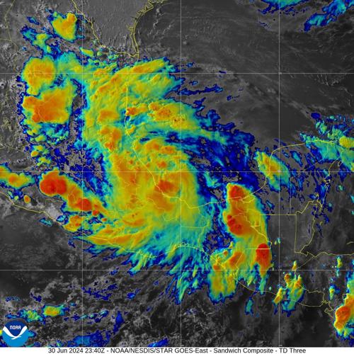
“Aircraft reconnaissance data and satellite-derived winds indicate that the low-pressure system that emerged over the southeastern Bay of Campeche this morning has become sufficiently organized to be classified as a tropical depression, the third tropical cyclone of the 2024 Atlantic hurricane season,” said U.S. Navy Hurricane Specialist Dave Roberts, who is assigned to the National Hurricane Center, in a forecast discussion message.
“Conventional satellite imagery shows developing curved bands in the northwest and northeast quadrants with a recent deep burst of convection near the surface center.”
![animated gif td3.gif](https://bloximages.newyork1.vip.townnews.com/nola.com/content/tncms/assets/v3/editorial/a/d3/ad360bc0-3741-11ef-96aa-87fa5fd679d8/6681f99506c57.image.gif 150w, https://bloximages.newyork1.vip.townnews.com/nola.com/content/tncms/assets/v3/editorial/a/d3/ad360bc0-3741-11ef-96aa-87fa5fd679d8/6681f99506c57.image.gif 200w, https://bloximages.newyork1.vip.townnews.com/nola.com/content/tncms/assets/v3/editorial/a/d3/ad360bc0-3741-11ef-96aa-87fa5fd679d8/6681f99506c57.image.gif 225w, https://bloximages.newyork1.vip.townnews.com/nola.com/content/tncms/assets/v3/editorial/a/d3/ad360bc0-3741-11ef-96aa-87fa5fd679d8/6681f99506c57.image.gif 300w, https://bloximages.newyork1.vip.townnews.com/nola.com/content/tncms/assets/v3/editorial/a/d3/ad360bc0-3741-11ef-96aa-87fa5fd679d8/6681f99506c57.image.gif 400w, https://bloximages.newyork1.vip.townnews.com/nola.com/content/tncms/assets/v3/editorial/a/d3/ad360bc0-3741-11ef-96aa-87fa5fd679d8/6681f99506c57.image.gif 540w, https://bloximages.newyork1.vip.townnews.com/nola.com/content/tncms/assets/v3/editorial/a/d3/ad360bc0-3741-11ef-96aa-87fa5fd679d8/6681f99506c57.image.gif 640w, https://bloximages.newyork1.vip.townnews.com/nola.com/content/tncms/assets/v3/editorial/a/d3/ad360bc0-3741-11ef-96aa-87fa5fd679d8/6681f99506c57.image.gif 750w, https://bloximages.newyork1.vip.townnews.com/nola.com/content/tncms/assets/v3/editorial/a/d3/ad360bc0-3741-11ef-96aa-87fa5fd679d8/6681f99506c57.image.gif 990w, https://bloximages.newyork1.vip.townnews.com/nola.com/content/tncms/assets/v3/editorial/a/d3/ad360bc0-3741-11ef-96aa-87fa5fd679d8/6681f99506c57.image.gif 1035w)
Animated satellite view of Tropical Depression 3 on Sunday evening, June 30, 2024. (NOAA)
Don't miss a storm update this hurricane season. Sign up for our free Hurricane Center newsletter.