A weakening Hurricane Beryl -- still a major, Category 3 storm with 115 mph winds -- was moving away from the Cayman Islands on Thursday morning and is forecast to make landfall early Friday on the east coast of the Yucatan Peninsula, according to forecasters at the National Hurricane Center.
The storm likely will be Category 2 strength by then, thanks to wind shear that has disrupted its internal core. But it will be strong enough to deliver up to 5 feet of storm surge plus strong waves within the east coast hurricane warning area on the peninsula, and as much as 3 feet of surge on the west coast of the peninsula, where a tropical storm warning is in effect.
Beryl still has not shown indications of a threat to the Louisiana coastline as it crosses the southwestern Gulf of Mexico enroute to a forecasted landfall near the Mexico-Texas border at about 10 a.m. Monday. It's forecast to be a Category 1 hurricane, with winds of 75 mph, at landfall.
![Forecast path](https://bloximages.newyork1.vip.townnews.com/nola.com/content/tncms/assets/v3/editorial/7/62/762767e0-3a21-11ef-953d-e7869dff511d/6686cc063adb6.image.png?resize=150%2C123 150w, https://bloximages.newyork1.vip.townnews.com/nola.com/content/tncms/assets/v3/editorial/7/62/762767e0-3a21-11ef-953d-e7869dff511d/6686cc063adb6.image.png?resize=200%2C164 200w, https://bloximages.newyork1.vip.townnews.com/nola.com/content/tncms/assets/v3/editorial/7/62/762767e0-3a21-11ef-953d-e7869dff511d/6686cc063adb6.image.png?resize=225%2C185 225w, https://bloximages.newyork1.vip.townnews.com/nola.com/content/tncms/assets/v3/editorial/7/62/762767e0-3a21-11ef-953d-e7869dff511d/6686cc063adb6.image.png?resize=300%2C246 300w, https://bloximages.newyork1.vip.townnews.com/nola.com/content/tncms/assets/v3/editorial/7/62/762767e0-3a21-11ef-953d-e7869dff511d/6686cc063adb6.image.png?resize=400%2C328 400w, https://bloximages.newyork1.vip.townnews.com/nola.com/content/tncms/assets/v3/editorial/7/62/762767e0-3a21-11ef-953d-e7869dff511d/6686cc063adb6.image.png?resize=540%2C443 540w, https://bloximages.newyork1.vip.townnews.com/nola.com/content/tncms/assets/v3/editorial/7/62/762767e0-3a21-11ef-953d-e7869dff511d/6686cc063adb6.image.png?resize=640%2C525 640w, https://bloximages.newyork1.vip.townnews.com/nola.com/content/tncms/assets/v3/editorial/7/62/762767e0-3a21-11ef-953d-e7869dff511d/6686cc063adb6.image.png?resize=750%2C616 750w, https://bloximages.newyork1.vip.townnews.com/nola.com/content/tncms/assets/v3/editorial/7/62/762767e0-3a21-11ef-953d-e7869dff511d/6686cc063adb6.image.png?resize=877%2C720 990w)
Hurricane Beryl's forecast path as of 10 a.m. Thursday. (National Hurricane Center)
The biggest threat to south Texas is likely to be heavy rains, as the storm is expected to move very slowly northwest, and still be a tropical depression by 8 a.m. Tuesday with its center near Laredo.
The Associated Press is reporting at least seven deaths resulting from Beryl’s fury, including four on the islands of Grenada, Carriacou and St. Vincent and the Grenadines, and three in northern Venezuela. Four people were reported missing in Venezuela.
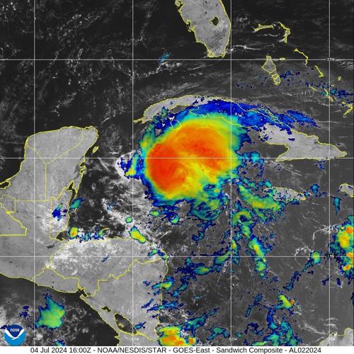
“Beryl continues to weaken due to the effects of westerly shear,” said Senior Hurricane Specialist Jack Beven in a 10 a.m. Thursday discussion message. “Radar data from the Cayman Islands shows that the eyewall is open to the south and that there is very little precipitation occurring in the southwestern semicircle. This matches the asymmetric cloud pattern seen in satellite imagery.”
#Beryl is still packing a punch. We were stuck in the soup all day. Every radar blip in the northern half was rough. Went from an open eyewall to fully closed as it approached Jamaica with a really nasty NE eyewall. Got hail the last two passes. This thing is a fighter. @53rdWRS pic.twitter.com/8cUCBRGEVL
— Jeremy DeHart (@JeremyDeHart53d) July 3, 2024
The clockwise winds around a large ridge of high pressure centered over the southeastern United States – the same one causing heat warnings in Louisiana – are expected to move Beryl in a west to west-northwest direction over the next day or two towards the Yucatan Peninsula, Beven said.
A trough of low pressure that’s expected to be in the central U.S. in two days should help turn Beryl more to the northwest as it’s moving over the Gulf.
Beven warned that differing models indicate the ultimate landfall on the Gulf’s west coast range from northeastern Mexico to the middle Texas coast, and pointed out that the center’s average track forecast error four days out is about 150 miles.
![Winds](https://bloximages.newyork1.vip.townnews.com/nola.com/content/tncms/assets/v3/editorial/7/58/758d543e-3a21-11ef-b0f5-eb35ba19655e/6686cc0538774.image.png?resize=150%2C123 150w, https://bloximages.newyork1.vip.townnews.com/nola.com/content/tncms/assets/v3/editorial/7/58/758d543e-3a21-11ef-b0f5-eb35ba19655e/6686cc0538774.image.png?resize=200%2C164 200w, https://bloximages.newyork1.vip.townnews.com/nola.com/content/tncms/assets/v3/editorial/7/58/758d543e-3a21-11ef-b0f5-eb35ba19655e/6686cc0538774.image.png?resize=225%2C185 225w, https://bloximages.newyork1.vip.townnews.com/nola.com/content/tncms/assets/v3/editorial/7/58/758d543e-3a21-11ef-b0f5-eb35ba19655e/6686cc0538774.image.png?resize=300%2C246 300w, https://bloximages.newyork1.vip.townnews.com/nola.com/content/tncms/assets/v3/editorial/7/58/758d543e-3a21-11ef-b0f5-eb35ba19655e/6686cc0538774.image.png?resize=400%2C328 400w, https://bloximages.newyork1.vip.townnews.com/nola.com/content/tncms/assets/v3/editorial/7/58/758d543e-3a21-11ef-b0f5-eb35ba19655e/6686cc0538774.image.png?resize=540%2C443 540w, https://bloximages.newyork1.vip.townnews.com/nola.com/content/tncms/assets/v3/editorial/7/58/758d543e-3a21-11ef-b0f5-eb35ba19655e/6686cc0538774.image.png?resize=640%2C525 640w, https://bloximages.newyork1.vip.townnews.com/nola.com/content/tncms/assets/v3/editorial/7/58/758d543e-3a21-11ef-b0f5-eb35ba19655e/6686cc0538774.image.png?resize=750%2C615 750w, https://bloximages.newyork1.vip.townnews.com/nola.com/content/tncms/assets/v3/editorial/7/58/758d543e-3a21-11ef-b0f5-eb35ba19655e/6686cc0538774.image.png?resize=897%2C736 990w)
This graphic shows the earliest reasonable estimate of the arrival of tropical-storm-force winds, 39 mph or greater, for Hurricane Beryl, as of 10 a.m. Thursday. (National Hurricane Center)
“Thus, it is still too early to pinpoint a specific region for the worst hazards” when Beryl’s final landfall occurs, he said.
Meteorologists in the Lake Charles office of the National Weather Service are taking heed of that concern.
“The most likely impacts for our area remain minor coastal flooding, but should the track get adjusted further northward in the coming days, those impacts will change/worsen...stay tuned,” they said in an message Thursday.
#Beryl has continued to slowly weaken, but I'm honestly a little surprised the core has held up some in the face of 30-40 knots of shear. Still a healthy northern eyewall, though the south side is open. Weakening should continue today - we'll see how much prior to the Yucatan. pic.twitter.com/fGhuAgopYb
— Andy Hazelton (@AndyHazelton) July 4, 2024
Forecasters are also tracking a fast-moving tropical wave over the eastern Caribbean Sea that has a 20% chance of forming into a tropical depression or storm over the next seven days.
This system is producing disorganized shower and thunderstorm activity as it moves west to west-northwest at 20 to 25 mph through the weekend, with gusty winds and heavy rainfall possible in the Greater Antilles over the next few days.
![Tropical wave](https://bloximages.newyork1.vip.townnews.com/nola.com/content/tncms/assets/v3/editorial/b/20/b203b4c2-3a25-11ef-8a73-23f18a851b48/6686d320a077d.image.png?resize=150%2C111 150w, https://bloximages.newyork1.vip.townnews.com/nola.com/content/tncms/assets/v3/editorial/b/20/b203b4c2-3a25-11ef-8a73-23f18a851b48/6686d320a077d.image.png?resize=200%2C148 200w, https://bloximages.newyork1.vip.townnews.com/nola.com/content/tncms/assets/v3/editorial/b/20/b203b4c2-3a25-11ef-8a73-23f18a851b48/6686d320a077d.image.png?resize=225%2C166 225w, https://bloximages.newyork1.vip.townnews.com/nola.com/content/tncms/assets/v3/editorial/b/20/b203b4c2-3a25-11ef-8a73-23f18a851b48/6686d320a077d.image.png?resize=300%2C222 300w, https://bloximages.newyork1.vip.townnews.com/nola.com/content/tncms/assets/v3/editorial/b/20/b203b4c2-3a25-11ef-8a73-23f18a851b48/6686d320a077d.image.png?resize=400%2C296 400w, https://bloximages.newyork1.vip.townnews.com/nola.com/content/tncms/assets/v3/editorial/b/20/b203b4c2-3a25-11ef-8a73-23f18a851b48/6686d320a077d.image.png?resize=540%2C399 540w, https://bloximages.newyork1.vip.townnews.com/nola.com/content/tncms/assets/v3/editorial/b/20/b203b4c2-3a25-11ef-8a73-23f18a851b48/6686d320a077d.image.png?resize=640%2C473 640w, https://bloximages.newyork1.vip.townnews.com/nola.com/content/tncms/assets/v3/editorial/b/20/b203b4c2-3a25-11ef-8a73-23f18a851b48/6686d320a077d.image.png?resize=750%2C554 750w, https://bloximages.newyork1.vip.townnews.com/nola.com/content/tncms/assets/v3/editorial/b/20/b203b4c2-3a25-11ef-8a73-23f18a851b48/6686d320a077d.image.png?resize=900%2C665 990w)
A tropical wave in the Caribbean Sea has a 20% chance of developing into a tropical depression or storm over the next seven days. (National Hurricane Center)
It is forecast to cross the Yucatan Peninsula and enter the southwestern Gulf of Mexico by early next week, and there's a chance of some development then, according to Senior Hurricane Specialist Brad Reinhart.