
TOTAL WASHOUT
Met Office map reveals exact spot set to be drenched in Storm Kathleen deluge amid string of new warnings for this week
Read below to find out if you'll be affected


THE Met Office has revealed which spots in the country are set to be drenched by Storm Kathleen later this week in a string of fresh warnings.
Yellow weather warnings have been issued for parts of the country on Tuesday with power and other services at risk of being disrupted.


The torrid forecast comes on the heels of Storm Kathleen, which continues to batter the country over the weekend.
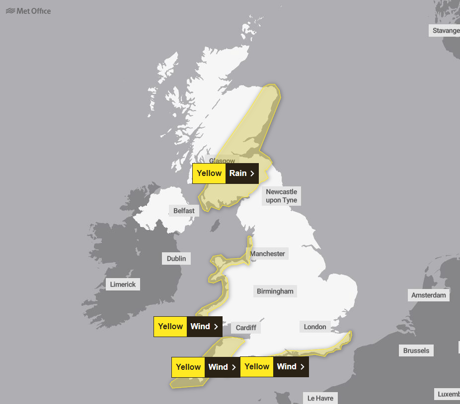
The Met Office says rainfall on Tuesday between 1am and 6pm could see some flooding in south and east Scotland.
Transport could be disrupted and homes damaged, with a slight chance of power cuts and the interruption of other services.
Coastal central and northern Wales, coastal Merseyside, and coastal Lancashire all have a yellow wind warning in place on Tuesday.
That warning exists between 1am and 3pm when strong winds bringing hazardous coastal conditions and travel disruption are expected to smash the coast.
Another yellow warning has also been put in place for Cornwall and Devon between 6pm on Monday and 6am on Tuesday.
Kathleen is expected to being strong winds and large coastal waves that could quickly move material and debris.
The south and southeast coast of England stretching from Weymouth to Deal will also see strong winds and the potential of inland disruption.
A yellow weather warning has been introduced for the coast between 1am and midday on Tuesday.
Warnings remain in place for today with the Met Office forecasting strong winds, accompanied by frequent squally showers, which may cause some travel disruption,
It also says there will be dangerous coastal conditions some coastal routes and sea frontage will see spray and/or large waves.
There is also a chance that some communities will have a short term loss of power and other services.
Meanwhile, the terrifying moment an Aer Lingus flight bouncess off the runway has been caught on film.
The Aer Lingus flight came into the runway at a sideways angle as Kathleen violently rocked it.
Its pilot managed to get wheels on the ground but could not secure a safe landing, bouncing back into the air.
The brave pilot flew around the runway and at last touched down safely.


Around 140 flights were cancelled across the UK yesterday as Kathleen grounded planes.
A new yellow wind warning will cover much of north west Scotland from until midnight tonight after it was extended this mornig..
The Met Office has also issued a further two yellow warnings for the coming week.
A rain warning will cover southern, central and eastern Scotland from midnight tonight until 6pm on Tuesday.
And a wind warning will be in force for Cornwall, Somerset and Devon from 6pm tomorrow until 6am on Tuesday.
Forecasters said that "squally showers" and "blustery winds" of up to 60mph could spark transport delays and power cuts.
Huge waves could also batter coastal roads and sea fronts in Argyll and Bute, the Highlands and Eilean Siar.
The Scottish Environmental Protection Agency has issued 18 regional flood alerts and 43 flood warnings.
It comes after 73mph winds were recorded in Drumalbin, South Lanarkshire.
THIS is the Met Office's advice to people in the Storm Kathleen warning zone:
Give yourself the best chance of avoiding delays by checking road conditions if driving, or bus and train timetables, amending your travel plans if necessary.
People cope better with power cuts when they have prepared for them in advance.
It’s easy to do; consider gathering torches and batteries, a mobile phone power pack and other essential items.
If you are on the coast, stay safe during stormy weather by being aware of large waves.
Even from the shore large breaking waves can sweep you off your feet and out to sea.
Take care if walking near cliffs; know your route and keep dogs on a lead.
In an emergency, call 999 and ask for the Coastguard. Be prepared for weather warnings to change quickly.
When a weather warning is issued, the Met Office recommends staying up to date with the weather forecast in your area.
Expert Vincent Fitzsimons said: "Scotland is braced for impacts from Storm Kathleen including very high winds and coastal flooding.
"On top of already high tides, Kathleen will bring a storm surge and large waves.
"This combination is particularly dangerous, especially around high tides.
"There is real danger to life from wave overtopping, particularly around causeways, coastal roads and paths.
"Disruption to travel and infrastructure is possible, as is isolated flooding to coastal properties and communities.
"While the risk is greatest around high tide times, our message is clear: take extra care if you are near the coast at any point and stay well clear of waves and water.
"Be careful when travelling around exposed coastal areas and don't walk or drive through flood water as there may be hidden hazards."
The storm battered much of the UK's west coast yesterday - but it was also the warmest day of the year so far.
A high of 20.9C was recorded at Santon Down in Suffolk, while 22.2mm of rain soaked the Isle of Harris.
Yellow wind and rain warnings are set to hit the country on Tuesday.
The Scottish south and east has a rain warning in place between 1am and 6pm.
Coastal central and north Wales, coastal Lancashire, and coastal Merseyside all have a strong wind warning in place between 1am on and 3pm.
Cornwall and Dorset also has a strong wind warning in place which begins at 6pm on Monday and ends 6am Tuesday.
Finally, the England southern and southeastern coast have a wind warning in place between 1am and midday on Tuesday.


