File:China prefectural-level divisions and administrative divisions (PRoC claim).png
跳转到导航
跳转到搜索

本预览的尺寸:759 × 600像素。 其他分辨率:304 × 240像素 | 607 × 480像素 | 972 × 768像素 | 1,280 × 1,012像素 | 2,560 × 2,023像素 | 6,246 × 4,937像素。
原始文件 (6,246 × 4,937像素,文件大小:987 KB,MIME类型:image/png)
说明
说明
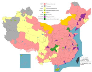
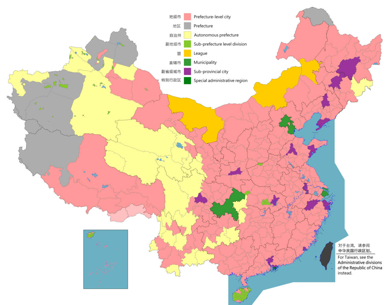
中國地圖顯示,分為省、直轄市、特別行政區、地級區劃、 和縣。


|
本地图上显示的边界是实际(de facto)情况。这只是对主题多种观点中的一种(参见COM:NPOV)。 |

|
该图像需要长期保持更新。如果有需要请更新该图像。
|

|
该文件可能会更新以反映新信息 如果您希望在不镜像新更新的情况下使用该文件的特定版本,请将所需版本作为单独的文件上传。 |
摘要
| 描写 |
English: Map of China, shows provinces, prefecture-level divisions, etc.
日本語:中国の地図、州、県レベルの区分などを示しています。
Русский: Карта Китая, показывает провинции, подразделения на уровне префектур и т. Д.
Монгол: Хятад улсын газрын зураг, мужууд, мужийн түвшний хэлтэс гэх мэтийг харуулсан.
中文(简体):中华人民共和国地图,显示省、地级区划等。(包含未实际控制之疆域)
中文(繁體):中華人民共和國地圖,顯示省、地級區劃等。 (包含未實際控制之疆域) |
||
| 地图图例 |
English:
Prefecture-level city
Prefecture
Autonomous prefecture
Sub prefecture-level division
League
Municipality
Sub-provincial city
Special administrative region 图例: 中文(简体):
地级市
地区
自治州
副地级市
盟
直辖市
副省级市
特别行政区 圖例: 中文(繁體): 地級市
地區
自治州
副地級市
盟
直轄市
副省級市
特別行政區 |
||
| 日期 |
English: File uploaded: November 6, 2021
English: Original uploaded: September 12, 2011
Latest update: 12:01, 9 August 2024 中文(简体):原始上传时间2011年9月12日
中文(繁體):文件上传时间2021年11月6日
中文(繁體):原始上傳時間2011年9月12日 |
||
| 来源 |
English: Source appearances: 中文(简体):来源于: 中文(繁體):來源於:
[]
|
||
| 創作作者 |
|
||
| 授权 (二次使用本文件) |
English: Map of China, administrative divisions: 中文(简体):中国地图,行政区划 中文(繁體):中國地圖,行政區劃 我,本作品著作权人,特此采用以下许可协议发表本作品:
|
||
| Geotemporal data | |||
| 描繪日期 | as of February 4, 2021 | ||
| 空间参照系统 | Custom | ||
| 地理参考 | |||
| 其他版本 |
English: Other languages: 中文(简体):其他语言: 中文(繁體):其他語言:
[]
Derivative works on these files: |
||


.png)
_sl.png)
许可协议
我,本作品著作权人,特此采用以下许可协议发表本作品:
本文件采用知识共享署名-相同方式共享 4.0 国际许可协议授权。
- 您可以自由地:
- 共享 – 复制、发行并传播本作品
- 修改 – 改编作品
- 惟须遵守下列条件:
- 署名 – 您必须对作品进行署名,提供授权条款的链接,并说明是否对原始内容进行了更改。您可以用任何合理的方式来署名,但不得以任何方式表明许可人认可您或您的使用。
- 相同方式共享 – 如果您再混合、转换或者基于本作品进行创作,您必须以与原先许可协议相同或相兼容的许可协议分发您贡献的作品。

|
此locator map图片可使用矢量图形重新创建为SVG文件。这具有很多好处;更多信息请参见共享资源:待清理媒体。如果存在此图片的SVG格式,请将其上传,然后将此模板替换为
{{vector version available|新图片名称}}。
建议您将SVG命名为“China prefectural-level divisions and administrative divisions (PRoC claim).svg”,这样在使用Vector version available(或Vva)模板时就不需要填写新图片名称参数。 |
|
|
此map图片可使用矢量图形重新创建为SVG文件。这具有很多好处;更多信息请参见共享资源:待清理媒体。如果存在此图片的SVG格式,请将其上传,然后将此模板替换为
{{vector version available|新图片名称}}。
建议您将SVG命名为“China prefectural-level divisions and administrative divisions (PRoC claim).svg”,这样在使用Vector version available(或Vva)模板时就不需要填写新图片名称参数。 |
| 註解 | 該圖片含有註解:在維基媒體共享資源上查看註解 |
.png)
Any autoconfirmed user can overwrite this file from the same source. Read COM:OVERWRITE first.
文件历史
点击某个日期/时间查看对应时刻的文件。
.png&uselang=zh&dir=prev)
.png&uselang=zh&offset=20220128000854)
.png&uselang=zh&offset=&limit=20)
.png&uselang=zh&offset=&limit=50)
.png&uselang=zh&offset=&limit=100)
.png&uselang=zh&offset=&limit=250)
.png&uselang=zh&offset=&limit=500)
| 日期/时间 | 缩略图 | 大小 | 用户 | 备注 | |
|---|---|---|---|---|---|
| 当前 | 2023年8月11日 (五) 02:26 | | 6,246 × 4,937(987 KB) | Vikarna(留言 | 贡献) | 州→地区 & 副地级划分→副地级市 |
| 2023年8月1日 (二) 08:59 |  | 6,246 × 4,937(987 KB) | Maanshen(留言 | 贡献) | Add Baiyang county-level city | |
| 2022年12月1日 (四) 09:50 |  | 6,246 × 4,937(987 KB) | Maanshen(留言 | 贡献) | Re-added disputed borders from the third version and removed the nine-dash line to prevent future bans to maps | |
| 2022年11月23日 (三) 05:28 |  | 6,246 × 4,937(951 KB) | Vikarna(留言 | 贡献) | municipality 市政府→直辖市 | |
| 2022年11月23日 (三) 05:10 |  | 6,246 × 4,937(986 KB) | Vikarna(留言 | 贡献) | League 联盟→盟 | |
| 2022年8月2日 (二) 23:06 |  | 6,246 × 4,937(992 KB) | Maanshen(留言 | 贡献) | Update disputed/claimed borders, white with stroke is not claimed and filled in color is claimed | |
| 2022年4月20日 (三) 00:08 |  | 6,246 × 4,937(975 KB) | Maanshen(留言 | 贡献) | Fix borders between Ili's Kuytun, Huyanghe, and Karamay | |
| 2022年3月1日 (二) 03:51 |  | 6,246 × 4,937(975 KB) | Maanshen(留言 | 贡献) | Update Shanghai land reclamation | |
| 2022年1月28日 (五) 08:26 |  | 6,246 × 4,937(975 KB) | Maanshen(留言 | 贡献) | Fix Changchun-Siping border | |
| 2022年1月28日 (五) 00:08 |  | 6,246 × 4,937(975 KB) | Maanshen(留言 | 贡献) | Add parts of Tiemenguan |
您不可以覆盖此文件。
文件用途
以下16个页面使用本文件:
- Top 200 locator map images that should use vector graphics
- Top 200 map images that should use vector graphics
- File:CPLDaAD(PRCc).png(文件重定向)
- File:China Counties.png
- File:China County-level cities.png
- File:China Districts.png
- File:China Prefectural-level.png(文件重定向)
- File:China Prefectural-level divisions (PRC claim).png(文件重定向)
- File:China Prefectural-level divisions (PRC claim) sl.png
- File:China prefectural-level divisions and administrative divisions (PRoC claim).png
- File:Cities in China.png
- File:Location of Qianjiang Prefecture within Sichuan.png
- File:ProvincialGDPofPRC.png
- Template:Other versions/China city-level source versions
- Template:Other versions/China prefectural-level other languages
- Category:Maps of prefecture-level divisions of China
.png&redirect=no)
.png&redirect=no)
全域文件用途
以下其他wiki使用此文件:
- ast.wikipedia.org上的用途
- bg.wikipedia.org上的用途
- cs.wikipedia.org上的用途
- en.wikipedia.org上的用途
- Administrative divisions of China
- User:Chochopk/Administrative divisions of the People's Republic of China
- List of prefectures in China
- Secession in China
- File talk:China prefectural-level divisions and administrative divisions (PRoC claim).png
- Prefecture-level divisions of China
- User:SilverStar54/Administrative divisions of China
- es.wikipedia.org上的用途
- fa.wikipedia.org上的用途
- fi.wikipedia.org上的用途
- fr.wikipedia.org上的用途
- hu.wiktionary.org上的用途
- id.wikipedia.org上的用途
- incubator.wikimedia.org上的用途
- ja.wikipedia.org上的用途
- pt.wikipedia.org上的用途
- ru.wikipedia.org上的用途
- sh.wikipedia.org上的用途
- si.wikipedia.org上的用途
- sv.wikipedia.org上的用途
- th.wikipedia.org上的用途
- tr.wikipedia.org上的用途
- ur.wikipedia.org上的用途
- vi.wikipedia.org上的用途
- www.wikidata.org上的用途
- wuu.wikipedia.org上的用途
- zh-yue.wikipedia.org上的用途
- zh.wikipedia.org上的用途
.png)
查看此文件的更多全域用途。
.png)
.png&oldid=907930470)