File:U.S. Territorial Acquisitions.png

Original file (1,536 × 1,038 pixels, file size: 1.11 MB, MIME type: image/png)
Captions
Captions
Summary
[edit]
| Description |
English: The Territorial acquisitions of the United States, such as the Thirteen Colonies, the Louisiana Purchase, the Oregon Country, the Mexican Cession, and so on. |
|||
| Date | 2017, 2022 | |||
| Source | National Atlas of the United States [1] | |||
| Author | United States federal government (en:User:pink and White converted it from JPEG to PNG and retouched it) | |||
| Permission (Reusing this file) |
|
|||
| Other versions |
Derivative works of this file: |

|
File:Aquired Lands of the US.svg is a vector version of this file. It should be used in place of this PNG file when not inferior.
File:U.S. Territorial Acquisitions.png → File:Aquired Lands of the US.svg
For more information, see Help:SVG. |
 |
(Uploaded using CommonsHelper or PushForCommons)
Possible Errors
[edit]
There is concern that this map could have errors. For discussion, please don't see the en:Image talk:U.S. Territorial Acquisitions.png talk page.
== Original upload log == Originally from en.wikipedia; description page is (was) here * 22:30, 31 May 2006 [[:en:User:Black and White|Black and White]] 1536×1038 (1,164,091 bytes) <span class="comment">('''{{PAGENAME}}''' == Summary == {{main|United States territorial acquisitions}} This image depicts the United States' historic acquisitions of territories, such as the Thirteen Colonies, the Louisiana Purchase, British and Spanish Cession, and so on. =)</span>
File history
Click on a date/time to view the file as it appeared at that time.
| Date/Time | Thumbnail | Dimensions | User | Comment | |
|---|---|---|---|---|---|
| current | 07:43, 6 December 2020 | | 1,536 × 1,038 (1.11 MB) | Petri Krohn (talk | contribs) | Reverted to original high-resolution version. If you have issues with terminology of the British Isles, at least keep the resolution of the map. |
| 01:52, 10 January 2016 | 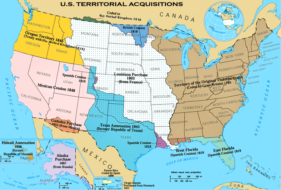 | 922 × 623 (574 KB) | Elevatorrailfan (talk | contribs) | The United Kingdom came into existence in 1801. | |
| 02:22, 16 April 2013 |  | 1,536 × 1,038 (1.11 MB) | Futurist110 (talk | contribs) | Reverted to version as of 17:56, 13 June 2012 | |
| 23:55, 15 April 2013 |  | 3,300 × 2,550 (702 KB) | Futurist110 (talk | contribs) | Higher resolution. | |
| 17:56, 13 June 2012 |  | 1,536 × 1,038 (1.11 MB) | Phoenix B 1of3 (talk | contribs) | Reverted to version as of 15:36, 16 September 2006 Undoing own revision per talk page | |
| 17:26, 13 June 2012 |  | 1,536 × 1,038 (1.12 MB) | Phoenix B 1of3 (talk | contribs) | color puerto rico to differentiate it from mexico and cuba. | |
| 15:36, 16 September 2006 | 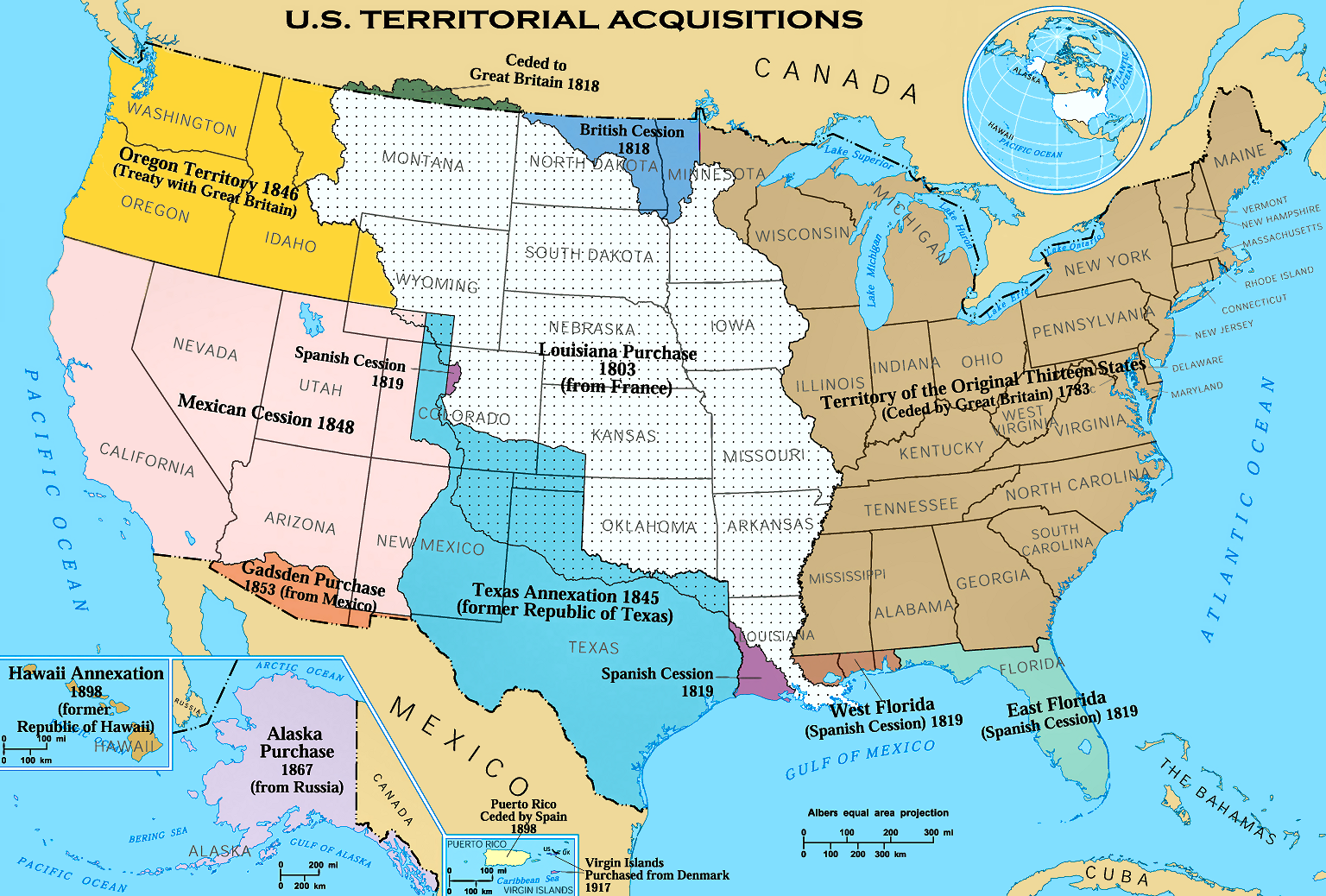 | 1,536 × 1,038 (1.11 MB) | Shizhao (talk | contribs) | {{Information| |Description= United States Territorial Acquisitions == Summary == {{main|United States territorial acquisitions}} This image depicts the United States' historic acquisitions of territories, such as the Thirteen Colonies, the Louisiana Pur |
You cannot overwrite this file.
File usage on Commons
The following 4 pages use this file:
File usage on other wikis
The following other wikis use this file:
- Usage on af.wikipedia.org
- Usage on am.wikipedia.org
- Usage on ar.wikipedia.org
- Usage on arz.wikipedia.org
- Usage on ast.wikipedia.org
- Usage on az.wikipedia.org
- Usage on bg.wikipedia.org
- Usage on bn.wikipedia.org
- Usage on ca.wikipedia.org
- Usage on ckb.wikipedia.org
- Usage on cs.wikipedia.org
- Usage on da.wikipedia.org
- Usage on de.wikipedia.org
- Usage on de.wikiversity.org
- Usage on dtp.wikipedia.org
- Usage on el.wikipedia.org
- Usage on en.wikipedia.org
- Louisiana Purchase
- Oregon Trail
- Indian Territory
- History of the United States
- Manifest destiny
- Gadsden Purchase
- Alaska Purchase
- American imperialism
- Adams–Onís Treaty
- U.S. territorial sovereignty
- Oregon Treaty
- Mexican Cession
- Historical regions of the United States
- Eastern United States
- Treaty of 1818
- Convention of 1800
- History of Western civilization
- User talk:Black and White
- National Atlas of the United States
- Treaty of Aranjuez (1779)
View more global usage of this file.
Metadata
- Territorial growth maps of the United States
- Maps of the United States
- Maps of the Louisiana Purchase
- National Atlas of the United States
- Colonialism of the United States
- 1846 treaties
- 1848 treaties
- 1819 treaties
- Gadsden Purchase
- London Convention (1818)
- Alaska Purchase
- 1898 in Hawaii
- Maps of the territorial evolution of the United States