
Swan River (Western Australia): Difference between revisions
m robot Removing: sv:Swan River |
|||
| Line 202: | Line 202: | ||
[[ru:Суон (река)]] |
[[ru:Суон (река)]] |
||
[[simple:Swan River]] |
[[simple:Swan River]] |
||
[[sv:Swan River, Western Australia (flod)]] |
|||
[[ta:சுவான் ஆறு]] |
[[ta:சுவான் ஆறு]] |
||
Revision as of 14:38, 14 April 2009

The Swan River estuary flows through the city of Perth, in the south west of Western Australia. Its lower reaches are relatively wide and deep, with few constrictions, while the upper reaches are usually quite narrow and shallow.
Course

The Swan River drains the Avon and Swan Coastal catchments, which have a total area of about 121,000 km². The Avon River contributes the majority of its freshwater flow. The climate of the catchment is Mediterranean, with mild wet winters, hot dry summers, and the associated highly seasonal rainfall and flow regime.
The Avon River rises near Yealering (pronounced Yellering), 100 km southeast of Perth: it meanders north-northwest to Toodyay (Toojay) about 90 km northeast of Perth, then turns southwest: in the Walyunga National Park, at the confluence of the Woorooloo Brook, it becomes the Swan River.
The Canning River rises not far from North Bannister, 100 km southeast of Perth and joins the Swan at Applecross, opening into Melville Water. The Swan and Canning rivers are salt water tidal rivers; Melville Water is their estuary, and is ideal for sailing of almost every description. Blackwall Reach is narrow and deeper, leading the river through Fremantle Harbour to the sea.
The Noongar believe that the Darling Scarp is said to represent the body of a Wagyl - a snakelike being from Dreamtime that meandered over the land creating rivers, waterways and lakes. It is thought that the Waugal created the Swan River.
While the Swan River has not been dammed, two of its tributary rivers - the Helena River and the Canning River - have been dammed for collection of water supplies, at Mundaring Weir and Canning Dam.
The estuary is subject to a microtidal regime, with a maximum tidal amplitude of about one metre, although water levels are also subject to barometric pressure fluctuations.
Geographic features

The major named geographic features of the Swan River are:
Natural history
Geology
Before the Tertiary, when the sea level was much lower than at present, the Swan River curved around to the north of Rottnest Island, and disgorged itself into the Indian Ocean slightly to the north and west of Rottnest. In doing so, it carved a gorge about the size of the Grand Canyon. Now known as Perth Canyon, this feature still exists as a submarine canyon near the edge of the continental shelf.
Flora and fauna

History

The river was named Swarte Swaene-Revier[1] by Dutch explorer, Willem de Vlamingh in 1697 , after the famous black swans of the area. Vlamingh sailed with a small party up the river to around Heirisson Island. A French expedition under Nicholas Baudin also sailed up the river in 1801.
Governor Stirling's intention was that the name 'Swan River' refer only to the watercourse upstream of the Heirisson Islands.[1] All of the rest, including Perth Water, he considered estuarine and which he referred to as 'Melville Water'. The Government notice dated 27 July 1829 stated ... the first stone will be laid of a new town to be called 'Perth', near the entrance to the estuary of the Swan River.
Almost immediately after the Town of Perth was established, a systematic effort was underway to reshape the river. This was done for many reasons:
- to alleviate flooding in winter periods;
- improve access for boats by having deeper channels and jetties;
- removal of marshy land which created a mosquito menace;
- enlargement of dry land for agriculture and building.
Perth streets were often sandy bogs which caused Governor James Stirling in 1837 to report to the Secretary of State for Colonies:
At the present time it can scarcely be said that any roads exist, although certain lines of communication have been improved by clearing them of timber and by bridging streams and by establishing ferries in the broader parts of the Swan River ...
Parts of the river required dredging with the material dumped onto the mud flats to raise the adjoining land. An exceptionally wet winter in 1862 saw major flooding throughout the area - the effect of which was exacerbated by the extent of the reclaimed lands.

A number of features of the river, particularly around the city, have reshaped its profile since European settlement in 1829:
- Claisebrook - named Clause Brook on early maps. This was a fresh water creek which emptied the network of natural lakes north of the city. Before an effective sewerage system was built, it became an open sewer which dumped waste directly into the river for many years during the 1800s and early 1900s. The area surrounding has been mainly industrial for most of the period of European settlement and it has a long history of neglect. Since the late 1980s, the East Perth redevelopment has dramatically tidied up the area and works include a landscaped inlet off the river large enough for boats. The area is now largely residential and the brook exists in name only with the lakes having been either removed or managed by man-made drainage systems.
- Point Fraser - early maps showed this as a major promontory on the northern side of the river west of the Causeway. It disappeared between 1921 and 1935 when land fill was added on both sides and effectively straightening the irregular foreshore and forming the rectangular 'The Esplanade'.
- The Esplanade - the northern riverbank originally ran close to the base of the escarpment generally a single block width south of St Georges Terrace. Houses built on the southern side of St Georges Terrace included market gardens which ran to the waters edge.
- Heirisson Islands - a series of mudflats that were slightly more upstream from today's single man-made island which has deep channels on each side.
- Burswood - early in the settlement the Perth flats restricted the passage of all but flat bottom boats travelling between Perth and Guildford. It was decided that a canal be built to bypass these creating Burswood Island. In 1831 it took seven men 107 days to do the work. Once completed, it measured about 280 metres in length by an average top width of nearly 9m which tapered to 4m at the bottom; the depth varied between nearly one metre and six metres. Further improvements were made in 1834. The area on the south side of the river upstream from the causeway was filled throughout the 1900s, reclaiming an area five-times the area of the Mitchell Interchange/Narrows Bridge works.
- Point Belches - later known as Mill Point, South Perth. Originally existed as a sandy promontory surrounding a deep semi-circular bay. This was later named Millers Pool and was eventually filled in and widened to become the present-day South Perth peninsula to which the Narrows Bridge and Kwinana Freeway adjoin.
- Point Lewis (also known as 'One-Tree Point' after a solitary tree that stood on the site for many years) - the northern side of the Narrows Bridge site, and now beneath the interchange.
- Mounts Bay - a modest reclamation was done between 1921 and 1935. In the 1950s works involving the Narrows Bridge started and in 1967 the bay was dramatically reduced in size with works related to the Mitchell Interchange and the northern approaches to the Narrows. An elderly Bessie Rischbieth famously protested against the project by standing in the shallows in front of the bulldozers for a whole day in 1967. She succeeded in halting progress - for that one day.
- Bazaar Terrace/Bazaar Street - in the early days of the settlement this waterfront road between William Street and Mill Street was an important commercial focus with port facilities including several jetties adjoining. It is now approximately where Mounts Bay Road is today and set well back from the foreshore. It had a prominent limestone wall and promenade built using material quarried from Mount Eliza.
- River mouth at Fremantle - the harbour was built in the 1890s and the removal of the limestone reef blocking the river was removed after 70 years of demands. The dredging of the area to build the Harbour effectively changed the river dynamics from a winter flushing flow to a tidal flushing estuary. It was also at this time that the Helena River was dammed as part of C. Y. O'Connor's ambitious and successful plan to provide water to the Kalgoorlie Goldfields.
The river has been used for the disposal all kinds of waste. Even well into the 1970s various local councils had rubbish tips on the mud flats along the edge of the river. Heavy industry also contributed its share of waste into the river from wool scouring plants in Fremantle to fertilizer and foundries sited in the Bayswater - Bassendean area. Remedial sites works are still ongoing in these areas to remove the toxins left to leach into the river.
During the summer months there are problems with algal blooms killing fish and caused by nutrient run-off from farming activities as well as the use of fertilisers in the catchment areas. The occasional accidental spillage of sewage and chemicals has also caused sections of the river to be closed to human access. The river has survived all this and is in relatively good condition considering on-going threats to its ecology.
The Perth Water location on the river adjacent to the City of Perth is a popular place for viewing the annual Australia Day fireworks, with over 400,000 people crowding the foreshore, Kings Park and boats on the river.

Governance
The Swan River Trust is a state government body, constituted in 1989 after legislation passed the previous year, that reports to the Minister for the Environment. It brings together eight representatives from the community, State and local government authorities with an interest in the Swan and Canning rivers to form a single body responsible for planning, protecting and managing Perth's river system.[2][3]
The Trust meets twice a month to provide advice to the Minister for the Environment, the Western Australian Planning Commission and local governments to guide development of the Swan and Canning rivers.
Human uses
Transport
In the earliest days of the Swan River Settlement, the river was used as the main transport route between Perth and Fremantle. This continued until the establishment of the Government rail system between Fremantle and Guildford via Perth.

Bridges


There are nineteen road and railway bridges crossing the Swan River. These are (from Fremantle, heading upstream):
- Fremantle Railway Bridge, Fremantle (Fremantle rail line)
- Fremantle Traffic Bridge, Fremantle
- Stirling Bridge (Stirling Highway), Fremantle
- Narrows Bridge (Kwinana Freeway/Mitchell Freeway, Mandurah rail line), Perth (2001) - northbound
- Narrows Bridge (Mandurah rail line), Perth
- Narrows Bridge (Kwinana Freeway/Mitchell Freeway), Perth (1959) - southbound
- The Causeway (north), Perth to Heirisson Island
- The Causeway (south), Heirisson Island to South Perth
- Goongoonup Bridge, East Perth (Armadale rail line)
- Windan Bridge, East Perth (Graham Farmer Freeway)
- Garratt Road Bridge, Maylands - northbound
- Garratt Road Bridge, Maylands - southbound
- Redcliffe Bridge (Tonkin Highway), Bayswater
- Guildford Road Bridge, Bassendean
- Guildford Railway Bridge, Bassendean (Midland rail line)
- Barkers Bridge, West Swan Road, Guildford
- Whiteman Bridge, Middle Swan
- Barrett Street pedestrian bridge, Upper Swan
- Upper Swan Bridge, Upper Swan
.jpg)
Cultural significance
There have been some north of the river or south of the river distinctions in the Perth metropolitan region over time, specially in the time up to the completion of the Causeway and Narrows bridges, due to the time and distances to cross the river. Some businesses do trade with a 'north of the river' phone number, and a separate 'south of the river' number.
Photo gallery
-
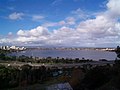 View from Kings Park over Perth Water
 -
 Narrows Bridge Perth
 -
 Another view of the Narrows
 -
 Northern section of the Causeway taken from Heirisson Island
 -
 Fremantle Traffic Bridge Structure
 -
 Stirling Bridge Fremantle
 -
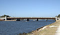
 Bassendean Rail and Road Bridges from Guildford Landing
 -
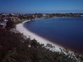
 Melville Water looking west from Heathcote Point
 -
 Waylen Bay viewed from Heathcote Point
 -
 A simple jetty at Blackwall Reach.
 -
 Sunset upon the Swan, Barkers Bridge, Guildford.


Notes
- ^ a b Seddon, George & Ravine, David (1986). A City and Its Setting. Fremantle Arts Centre Press. ISBN 0949206083.
{{cite book}}: CS1 maint: multiple names: authors list (link) - ^ "Home page". Swan River Trust. Government of Western Australia. Retrieved 2008-12-02.
- ^ Swan River Trust Act 1988. WA state govt.
References
- Seddon, George (1970). Swan River Landscapes. University of Western Australia: Printing Press. ISBN 0-85564-043-X.
- Burnignham, Nick (2004). Messing About in Earnest. Fremantle Arts Centre Press. ISBN 1-920731-25-3.
- Brearley, Anne, Ernest Hodgkin's Swanland : estuaries and coastal lagoons of South-western Australia Crawley, W.A. : University of Western Australia Press for the Ernest Hodgkin Trust for Estuary Education and Research and National Trust of Australia (WA), 2005. ISBN 1-920694-38-2
Further reading
- Thompson, James (1911) Improvements to Swan River navigation 1830-1840 [cartographic material] Perth, W.A. : Western Australian Institution of Engineers, 1911. (Perth : Govt. Printer) Battye Library note: - Issued as Drawing no. 1 accompanying Inaugural address by Thompson 31 March 1910 as first president of the Western Australian Institution of Engineers, - Cadastral base map from Lands and Surveys Dept with additions by Thompson showing river engineering works from Burswood to Hierrison [i.e., Heirisson] islands and shorelines as they existed 1830-1840; includes Aboriginal place names along Swan River Estuary.
External links
- Swan River Trust
- Bridging to South Perth by Lloyd Margetts A copy of his speech given to the South Perth Historical Society.
31°56′50″S 115°54′58″E / 31.94722°S 115.91611°E
| Australian continent / Australian mainland |  | |
|---|---|---|
| Queensland |
| |
| Northern Territory |
| |
| Western Australia |
| |
| South Australia |
| |
| Tasmania |
| |
| Related topics | ||
| ||