KML and Earth had a really great year in 2010. Toward the end of the year, we added a bunch of new stuff, and wanted to recap it to let you know what we’ve been up to.
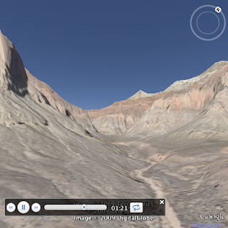
Google Earth 6.0 was launched on Nov 29th, and with it came a whole host of new features. Trees, a new Street View mode in Earth, new measuring tools. But along with the product features, it came with some new KML extensions as well:
Of course you can also check out the KML reference, check for things marked New!, and the Earth API release notes for more info.
From the earliest days of Google Earth, (and even back when it was still called Keyhole,) developers have wanted control over the globe to create their own 3D Earth applications. In response to this need, the Keyhole team added a COM API to the Keyhole app, to allow further customization of users’ Google Earth experience. When Keyhole became Google Earth in 2005, this API was carried over. Though we never provided much support, developers discovered the COM bindings and a few intrepid developers sorted through the vagaries of COM programming. Eventually we had a small but committed development community demanding documentation, which we released in 2007. We saw some interesting uses for the COM API, particularly by Enterprise users and broadcasters. Mostly, though, people wanted to put Earth in their web applications.
In 2008, we released the Google Earth API and browser plug-in. This robust JavaScript API is more powerful than the COM API, and can be used on a variety of platforms to deliver compelling 3D applications over the web based on the Google Earth technology. At the same time, we stopped development on the COM API and began encouraging developers to migrate to the Earth API instead. Today, more and more apps are being written in JavaScript, and COM itself is no longer a widely used technology, so the time has come to retire the Google Earth COM API.
Today we’re announcing that the Google Earth 5.2 client will be the last version that supports the COM API. Earth 5.2 and older clients will continue to support the COM API while these versions are supported. Future releases will no longer have COM API bindings. We believe that the JavaScript API provides the best mechanism for reaching the most developers.
We realize that a few of you will be disappointed by this news, however we are happy to work with you to transition off of COM onto JavaScript. Please see the documentation for more information on how to work with the Earth API, and visit our active developer forum for support. Enterprise customers can also contact Enterprise support with any questions. If you have a feature from COM that you can’t live without, please let us know about it by adding it as a feature request in our issue tracker, and starring other requests.
Posted by Mano Marks, Geo APIs Team
Opening ceremonies for the 2010 Winter Olympics are just days away and the city of Vancouver glitters in festivity. Its nightly sky has been adorned with 20 robotic searchlights thanks to Rafael Lozano-Hemmer at “Vectorial Elevation” powered by Google Maps and Google Earth APIs.
The user interface for personalization is very intuitive, consisting of an interactive Google Maps view of an overlay of search lights in Vancouver and a 3D view of Vancouver in Google Earth. User selections and configuration of search lights are adjusted using the jQuery JavaScript library and Maps API, and are dynamically reflected in the 3D Earth view using the Earth API.
Find out more on the Google Blog about Google's other offerings like Street View snowmobile for fans of the Games. Or personalize your own Vancouver nightly skyline and let your imaginations and Olympic spirits soar!
We're really excited to announce two upcoming hackathons for our Google Geo APIs. The first will be held in New York City on November 20th followed by a second one in Mountain View on December 15th. This will be a great learning opportunity for any developer interested or currently involved in building Geo-enabled applications using our APIs. Come join us for a great session where you'll be able to hack away on your own projects alongside our engineers who'll be readily available to provide support.Below is a list of the various Google Geo APIs you'll learn about:
Registration for these events are completely free, and space is limited. Reserve your spot now using the following links below!
Bring your laptops, your brains, and we'll see you soon!
Just like Ricky Bobby, I like going fast. Most of the time, though, going too fast in real life can be dangerous. That's why I also enjoy playing driving games and simulators—all from the comfort and safety of my own home!
The great thing is, thanks to the Earth API and Maps API for Flash, developers have built a flurry of simulator applications that are visually stunning, geographically realistic, and highly addictive. Below are some of my favorite simulators for driving, sailing, running, and even landing on the moon!
WARNING: I will not be held liable for any lost productivity resulting from these awesome apps!
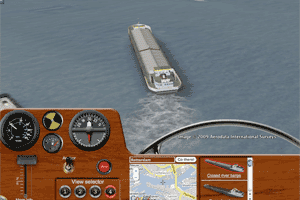
Considered by most to be in the list of top Earth API apps, Ships is a highly polished simulator by New Zealand-based Dinther Product Design for a variety of sea vessels (and a blimp!). The visual effects (i.e. the ship's wake using animated ground overlays), camera angles, and detailed screen overlay-based dials make Ships an exceptionally fun and immersive simulator.
Primary API: Earth API
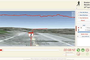
Although I don't have the endurance to run a marathon, I can still check out various marathon routes with the help of Race My Race! This app is a really fun way to explore the terrain along these difficult routes. And, if you're planning on running a marathon in the near future, this site can even help you prepare!
Ever want to explore the world's great bodies of water? Sea-Seek's Virtual Dive is perfect for just that! This app lets you commandeer a variety of air, ocean surface, and underwater vessels along coastlines and even in the deep blue sea! My favorite vessel is the 'Shark Sub,' equipped with a headlamp model.
The original, 2D version of this simulator was very impressive—it allowed you to drive a car or truck in a city of your choosing in a Grand Theft Auto-like perspective. This version, however, one-ups the original by utilizing the new 3D perspective in the Maps API for Flash with a 3D car model for a more realistic feel. A great game from a great developer in Japan!
Primary API: Maps API for Flash
Another gem from Dinther Product Design, this challenging, but very fun, minigame lets you attempt to land the Apollo 11 Moon Lander. I personally have never been able to land without crashing, but a few of my coworkers had no problem finishing with a successful 'Eagle Touchdown.' To them, I say: apply to NASA!
This is a super-mashup of a number of Google and non-Google APIs, allowing you to visualize—in every way imaginable—the driving route between two addresses. The demo really shows off what's possible with today's geo platforms. Very exciting stuff!
Primary API: Various
I hope you enjoyed trying out these simulators; maybe a few of you were inspired to write your own simulation apps! I bet we'll be seeing more and more of these types of apps in the future. 'Til next time, thanks for reading and drive safely!
Calling all Bay Area coders! We've just finalized another hackathon for late September! On September 24th, 2009, from 1:30 to 8, Google will host a hackathon for our Geo APIs in our San Francisco office. At the hackathon, Google engineers will give one or two API overview presentations and then will be on hand to answer all your geo related questions. You can work on suggested codelabs, or just bring your own project and we'll lend you a hand.
The hackathon will cover the following APIs:
Space is limited, so register now! And remember, this will be a code-heavy event, so bring your laptop and come ready to code!
Posted by Roman Nurik, Geo APIs team
So bring your laptops, and your brains, and be prepared to code.
Space is limited, so register now!
For those of you who don't currently have the plugin installed, here's what you're missing:
I hope that this new feature gives rise to some great new Moon mashups in the browser!
This Monday, at the Newseum in Washington D.C., we unveiled Moon in Google Earth as the newest 3D-navigable celestial sphere, after Mars and Sky. Users can now explore some fantastic 3D terrain and imagery of the moon's surface, as well as exciting interactive media content about the Apollo missions and more, right in Google Earth!
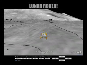
Today, I'm glad to help commemorate the 40th anniversary of the Apollo 11 landing by announcing support for the moon in the Google Earth API. Just like with Mars, Earth API developers can now choose to show the moon upon instantiating the Google Earth Plugin. Here's a new demo, based on the original Monster Milktruck game, that you can check out to get a glimpse of Moon in the browser:
Lunar Rover
We've also added support for the Moon, Mars, and Sky to the KML embed and tour embed gadgets. Here's a quick demo of the fantastic Apollo 11 tour, created by Sean Askay, embedded in the browser using the touring gadget:
When the Earth API launched back in May 2008, there was a simultaneous addition to the Maps API that allowed creating an 'Earth' map type with just a single line of code:
map.addMapType(G_SATELLITE_3D_MAP);
This was really the first time that the 2D world of Google Maps and the 3D world of Google Earth came together. Users could navigate content publishers' geographic content in 2D or 3D, whichever they desired.
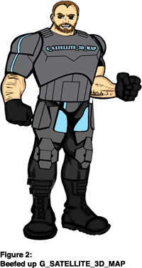
However, there were a few limitations with G_SATELLITE_3D_MAP. For example, only Maps markers and polylines were synchronized in 2D and 3D. Other overlay types were not kept in sync. Also, the transition from 2D and 3D wasn't as transparent to the user as it could've been. See Figure 1 to the right for an artist's depiction of the feature set.
G_SATELLITE_3D_MAP
Today, we're excited to announce a completely rewritten and 'beefed up' G_SATELLITE_3D_MAP (see Figure 2), available now in the latest experimental version of the Maps API (currently 2.160). While the usage is the same (simply use the line of code above), the overlay/feature synchronization is much more extensive, the 2D/3D transitioning is seamless, and the overall Maps/Earth integration is much stronger.
Most common Maps API overlays are now supported: markers, polylines, polygons, ground overlays, screen overlays, and even GGeoXml objects are automatically mirrored in the Google Earth Plugin. In fact, GGeoXml works in an especially powerful way: although Maps may not display all KML from a GGeoXml (i.e. 3D models), the Earth Plugin will show all the content, in all its 3D glory.
GGeoXml
If you're as psyched as I am about the new features and want to give them a go, check out these demos and the short screencast below:
To enable the new Maps/Earth integration on your site, simply load the experimental Maps API version using:
google.load('maps', '2.160');
and add the G_SATELLITE_3D_MAP map type. When Maps API v2.160 or later becomes version '2', the new Maps/Earth integration will replace the old version, which will then only be available by hard coding to version 2.159 or earlier in the google.load statement.
google.load
Lastly, if you have any trouble with the new integration code, please post in the Maps API or Earth API developer forums. Also see the Earth API notify group announcement for more details on this release.
Posted by Roman Nurik, Google Geo APIs Team
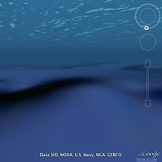
Last month, the Google Earth team made a splash in the news (pun intended) with the release of Google Earth 5.0. The update included the ability to dive underwater to explore the world's oceans, record and play back narrated tours, view historical imagery, and explore Mars in 3D. Today, our team is happy to announce the 5.0 version of the Google Earth Plugin!
If you've already installed the plugin, you should see the new version automatically within the next day or two. If not, you can download the plugin for Windows or Mac OS X by visiting any Earth API web site, such as Monster Milktruck and clicking 'Get The Google Earth Plugin now'.
We've added many of Google Earth 5.0's new capabilities to the plugin and API, as well as a few other frequently requested features. Here is a list of major new features in the plugin and API:
ALTITUDE_CLAMP_TO_SEA_FLOOR
ALTITUDE_RELATIVE_TO_SEA_FLOOR
KmlTour
GETourPlayer
KmlPhotoOverlay
GEPhotoOverlayViewer
LAYER_BUILDINGS_LOW_RESOLUTION
Along with these major new features, we've implemented the following feature requests from the public issue tracker: 10, 27, 42, 49, 99 and fixed these publicly reported defects: 75, 118, 131, 148. Check the Earth API release notes for more details.
The full list of a new samples for this release can be found at the Earth API demo gallery.
On our agenda for the not-too-distant future is:
Lastly, if you're yearning for more Earth API goodness, make sure to catch my Google Earth API session at Google I/O on May 27th and 28th. Discounted early bird registration ends May 1st, so register now before time runs out!.
March 5th, from 3-9pm, Google will be hosting a Google Geo APIs hackathon at our Manhattan offices, 111 8th Avenue at 15th street in Manhattan. Join us for some hacking around on Google Geo APIs. Work on our learning materials, or work on your own projects. There will presentations on new features in the APIs, and plenty of Geo Googlers around to help you with your technical questions. In particular, we will be helping people with the Google Maps API, the Google Earth API, and KML.
To register, click here. Space is limited, so you may want to register now.
Recently, we released three new resources for KML and the Google Earth API:
A long time ago, at a conference not too far away, Google launched the Google Earth Browser Plugin, with the Google Earth API. At the time, we promised that we would bring it to the Mac, and now we have.
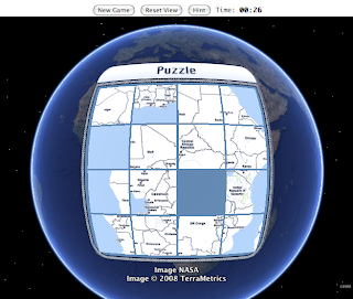
Today, we're excited to announce the release of the Google Earth Browser Plugin for Mac OS X 10.4+ (PowerPC and Intel). The Mac plugin is supported on Safari 3.1+ and Firefox 3.0+. The download link should now be available to all users from any Earth API-powered site. We also released a game, Puzzler, in honor of the new Mac plugin. It is, of course, playable on a PC as well. And as usual, it's open source, so you're free to adopt the code.
In addition to the Mac release, we've also upgraded the Windows version of the plugin. See the release notes for more details.
Hi, I'm Oliver Oxenham, posting about the National University of Singapore (NUS) Library 3D interior mapping. After investigating a few other development options, we decided to go forward with Google Earth Plugin especially because of its API's ease of use -- there was no need for us to reinvent the wheel in the area of 3D display in the browser and camera movements in a 3D environment.
The NUS library features a few innovative uses of GE plugin as well as Google App Engine. App Engine is the platform that controls all the information you see in this 3D application. We offer our customer an administrative interface to allow them to create their own placemarks (landmarks) within the 3D library as well as choose to make them visible or invisible. The contents of the landmarks are editable. It can display formatted text or even videos. Additionally, customized orientation tours can be created on the fly by the user who only has to select a list of landmarks and arrange them in the order they want the tour to play.
The GE plugin displays a 3D model of the NUS library with the earth covered with a black layer so as to make the model stand out more and avoid distracting the user with unnecessary features. The navigation on the right is automatically generated based on the landmarks created by the user. It allows the viewer to navigate through the library from landmark to landmark.
The application also allows 3D book search. Google App Engine datastore keeps a catalogue of book call numbers and shelf references. When the viewer enters a call number in the search box, the latitude and longitude of the appropriate shelf is retrieved and located in 3D.
All these adds to the fact that we are using the GE plugin for an interior 3D of a building instead of the usual outdoor of an area. We believe that a lot of our implemented features can still be improved and we're working hard to improve them and make them more generic and reusable in the future. We believe 3D interiors can be attractive to some customers.
OK, it's not exactly a manual, actually a handbook, The KML Handbook by Josie Wernecke. Josie is the Google tech writer who wrote the KML 2.1 and 2.2 documentation, and also helped write the KML 2.2 OGC Specification. So she knows what she's talking about!
The KML Handbook is the most complete treatment of KML in print. It explains all the various elements and features of KML. It also examines both well known topics like Regionation, and lesser known topics like View Based Refresh. It is also the only book on KML officially endorsed by Google.
The book is available for pre-sale from Amazon and O'Reilly, and should be available for immediate purchase soon. So for all those would-be Santa Trackers, and anyone else in the geographic world, you now have a great holiday gift.
Howdy, everyone! I'm sure that after reading countless posts on the Geo Developers blog and writing tons of code using Google Geo APIs and other development kits, you're all experts with KML. I mean, you obviously know that to create a polygon, you simply need a <Placemark>, with a <Polygon> containing an <outerBoundaryIs> consisting of a <LinearRing> with a <coordinates> element which contains a series of (longitude, latitude, altitude) tuples... and, you didn't forget that you need to repeat your first coordinate tuple again at the end, right? Heh, well maybe not. For those of you can recite the entire OGC KML v2.2 schema from memory in one go, you can probably stop reading.
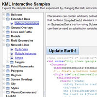
To the 99.9% of us who don't know everything there is to know about KML, and have been looking for a way to explore this curious little language, I present a new learning and exploration tool called the KML Interactive Sampler. One caveat, though -- since the sampler uses the Earth Browser Plug-in and API, the Earth view will currently only work on Windows.
Mac folks... be patient, a seriously awesome Mac version of the plugin is in the works!
Here are a few screenshots of the sampler to whet your appetite:
So, if you're just starting out with KML, or brushing up on your existing skills or maybe just looking to play around with a cool new toy, definitely check out the new sampler. If you have any trouble using it, feel free to comment in the Getting Started with KML support forum.
Thanks, and enjoy!
Give us feedback in our Product Forums.