Powerful nor’easter to bring heavy rain, wind and possible snow to NYC as Hochul declares state of emergency upstate
Old Man Winter ain’t done yet.
A powerful, multi-day nor’easter is expected to blast the Northeast during the first half of the work week, bringing strong wind gusts and heavy rain — and the possibility of some snow — to the Big Apple.
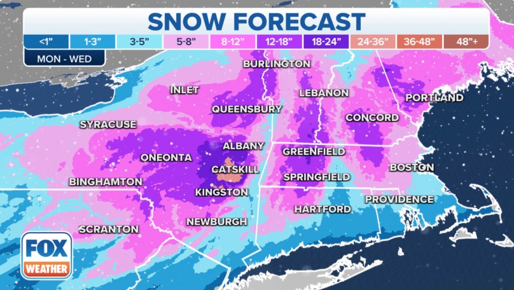
Gov. Kathy Hochul declared a state of emergency and mobilized the National Guard Monday as upstate New York was set to get hit with a massive winter storm expected to drop two feet of snow from the Syracuse area to the Buffalo region.
Hochul said the National Guard would be mobilized along with 8,000 utility workers in anticipation of the snow emergency that was expected to officially begin at 8 p.m. Monday night.
The powerful, Monday into Tuesday nor’easter was expected to blast the northeast, bringing strong wind gusts and heavy rain — and even the possibility of some snow — to the Big Apple as well.
“This is a serious Nor’easter. It is something to be taken extremely seriously, and that’s what we’re doing here in the State of New York. And we encourage everyone to heed these warnings. This is your chance today. Get what you need, cancel your plans,” Hochul said at a storm briefing outside Albany Monday.
A storm started taking shape Monday morning off the Carolina coast but will push northeast, bringing a bout of heavy rain to New York by the afternoon.
As the storm progresses toward Nantucket, cold air may work its way toward the Big Apple and open the door to the possibility of snow, Fox Weather meteorologist Christopher Tate told The Post.
“It could be heavy at times if we do switch over because the storm is forecast to have a lot of moisture with it. So if we do switch over to snow, we will likely see intervals of moderate to heavy snow reducing visibility,” Tate said.
Any snow that falls likely won’t stick as temperatures will remain above 32 degrees for the entirety of the storm.
“New York is a fantastic urban heat island which means the city is always warmer than the surrounding area. So you know we were probably not going to get any type of blockbuster snow,” Tate said.
The Fox Forecast Center predicts between 1 and 3 inches of snow will be measured in Central Park if the conditions align enough for flakes to fall during this week’s squall.
Warmer temperatures mean people driving to work Tuesday morning likely will not see ice or snow causing major issues on the roads. Areas north of Manhattan, where snow has a higher probability of sticking to the ground, may experience some issues.
Suburbanites in North Jersey, areas north of Yonkers and around Stamford have better chances of getting snow that sticks to the ground and accumulates, Tate said.
Parts of western and northern New England into upstate and central New York should see the heaviest snowfall. The amount of snow expected will decrease closer to the Interstate 95 corridor, including Boston and New York City, where the heaviest rain is anticipated.
New Yorkers in Long Island will likely see heavy rain as the storm picks up Monday evening.
There are currently coastal flood advisories up for all of Long Island east of Queens.
During the height of the storm, there may be sporadic wind gusts reaching up to 45 miles per hour in New York City and on Long Island.
The robust wind may cause additional flooding especially in those regions and in other low-lying areas.
The storm is expected to move out of the region by the end of Wednesday, but strong, gusty winds will linger for days, leaving the city in a chill.
Hochul acknowledged Monday that she was moving relatively fast to this storm after facing criticism that she did not act quickly enough in late December to minimize death and damage to a deadly blizzard that battered her hometown of Buffalo.
“The National Guard we have pre-positioned earlier, so that’s something that’s important,” she told The Post when asked how she was applying lessons learned from the historic storm.
But she claimed there was a key difference between the two storms.
“The advantage now is we know the geographic area we have more predictably,” Hochul said. “The day before the Buffalo event, it was still expected to be a statewide event so you don’t know where National Guard needs to be.”


