Landslides block roads in Los Angeles area as California faces rare tornado threat during atmospheric river
SAN FRANCISCO – The gloomy stretch of extreme weather in California is continuing into a new workweek as another multiday atmospheric river storm slams the Golden State with flooding rain, damaging wind gusts, landslides in the Los Angeles area and even a rare tornado threat that has millions of people across the region on alert for severe weather.
Impacts from this latest round of potentially dangerous weather began on Sunday when torrential rain and strong winds lashed communities from Northern California to Southern California, with numerous reports of flooded roads and downed trees and power lines.
And, unfortunately, this isn’t a fast-moving storm by any means.
This atmospheric river is expected to linger out over the Pacific Ocean and will continue to funnel rounds of precipitation in the form of heavy rain and mountain snow up and down the state through Wednesday.
California seeing heavy rain, flash flooding on Monday
This latest storm got underway as the weekend started to wind down, and the FOX Forecast Center said this atmospheric river will be more impactful than previous ones that have recently affected the state.
By Monday morning, heavy rain was soaking areas of the Golden State from the Central Valley to portions of Southern California, as well as the San Francisco Bay Area.

A Flash Flood Warning was issued by the National Weather Service for the Santa Monica mountains eastward to the Hollywood Hills and Griffith Park, as well as the surrounding Malibu and San Fernando Valley areas until 6 p.m. PST, which affects portions of southwestern Los Angeles and southeastern Ventura counties.
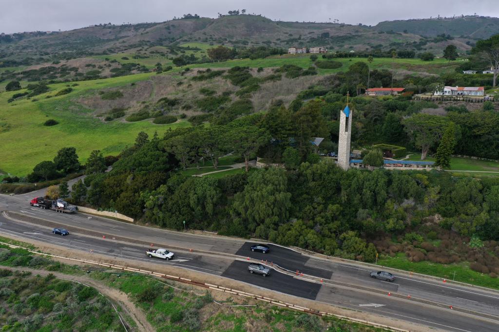
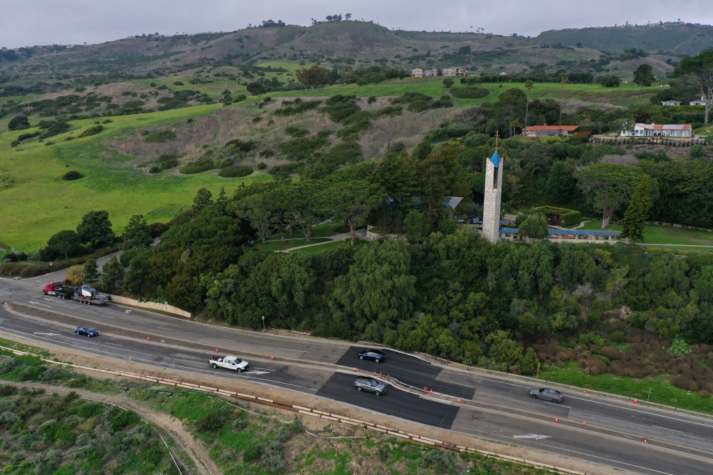
According to the National Weather Service, a landslide has already been reported in the Los Angeles area east of Point Mugu in Ventura County.
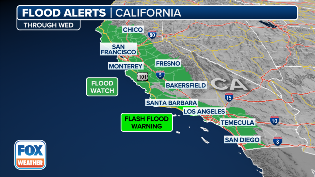
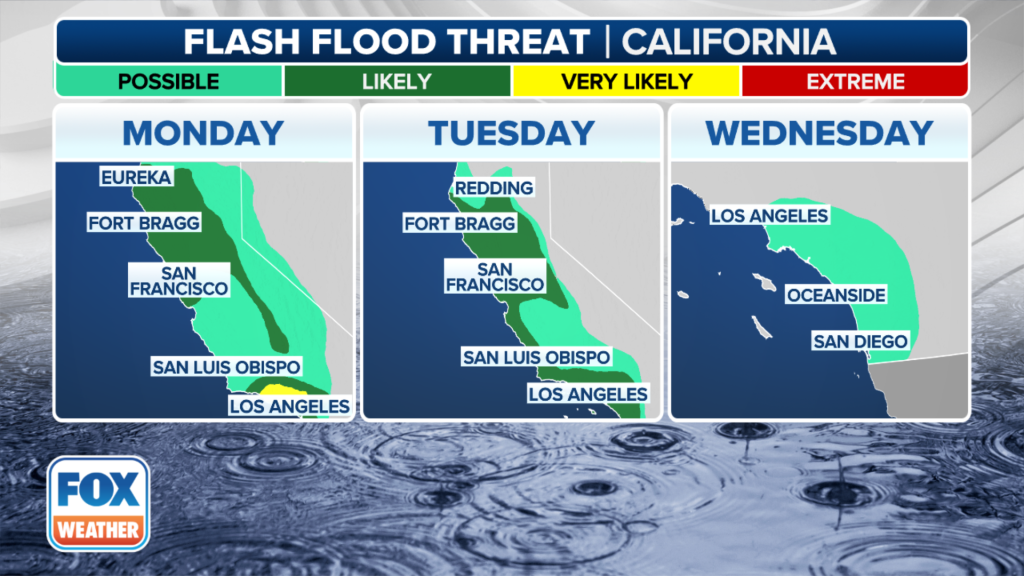
NOAA’s Weather Prediction Center (WPC) has placed a Level 3 out of 4 risk of flooding in portions of Santa Barbara, Ventura and Los Angeles counties in Southern California on Monday, with a majority of the state under a Level 2 out of 4 risk.
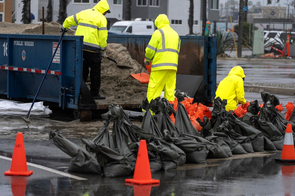
Flooding has already been a problem in Santa Barbara, where officials announced the closure of Santa Barbara Airport (SBA) because of flooding on the runway.
“Commercial flights have been canceled, general aviation operations are paused, and the terminal is closed,” the airport said on X, formerly Twitter.
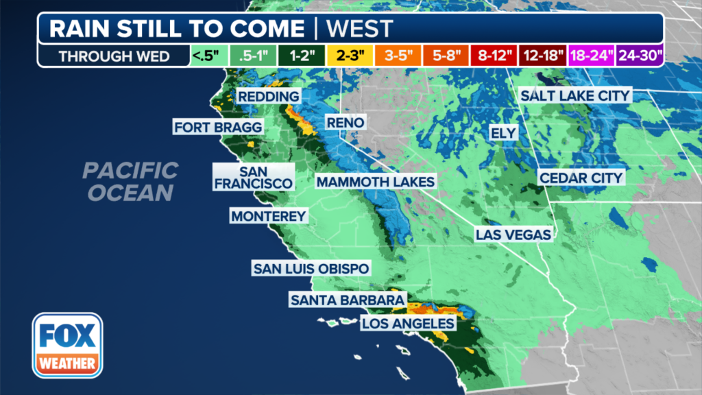
The flood threat on Tuesday will be slightly less than what is being seen on Monday, with areas of California from Fort Bragg through the San Francisco Bay Area and south along the coast into San Luis Obispo, Los Angeles and San Diego on the U.S.-Mexico border placed in a Level 2 out of 4 risk of flooding.
The flood threat extends into Wednesday, with communities from Los Angeles to San Diego placed in a Level 1 out of 4 risk of flooding.
Landslides, flooding reported during storm
Impacts from this atmospheric river storm hitting California started being reported on Sunday night as the first effects began.
Flooded roads were reported in the Sacramento and San Jose areas, according to reports from the NWS.
The NWS also reported a landslide in the Larkfield-Wikiup area north of Santa Rosa on Sunday night that blocked Mark West Springs Road.
The strong winds also brought down numerous trees in the Santa Cruz area.
Massive boulders about half the size of cars were reported across Gibraltar Road in the Montecito area, as well as boulders across Ladera Drive in the Summerland area.
Trees have been reported across roads in the Woodland Hills area in Southern California.
FOX Weather Correspondent Robert Ray was in Pacifica, California, on Monday and shared video of massive waves that have been crashing onshore.

Winds there have been whipping upwards of 50 mph.
California sees rare tornado risk on Monday
Flooding isn’t the only concern as this latest atmospheric river storm slams California.
There’s now a threat of severe weather, including possible tornadoes, in portions of Central and Northern California on Monday. Other threats from thunderstorms that develop include damaging wind gusts.

NOAA’s Storm Prediction Center has placed parts of California’s Sacramento Valley region under a Level 2 out of 5 on its severe thunderstorm risk scale.
The Level 2 risk includes Sacramento, Stockton and Modesto. The FOX Forecast Center said that computer forecast models seem to be hinting at more clearing and breaks in the clouds later in the day on Monday.
That will allow for more instability in the atmosphere, leading to a setup that favors the organization of strong to severe thunderstorms.
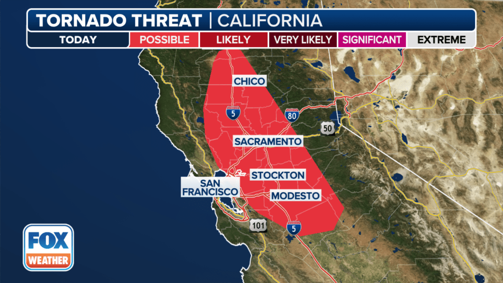
The tornado risk runs from north of Chico through Sacramento and Stockton and into Modesto.
The eastern shores of San Francisco Bay are also under the low risk of tornadoes on Monday.
Winds will be whipping in California
Damaging wind gusts are also possible as the atmospheric river storm slams into California early this week.
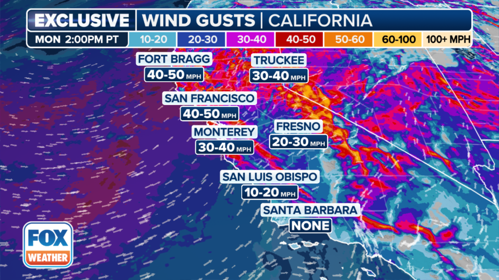
“(The winds) are going to be pretty gusty and strong,” FOX weather Meteorologist Craig Herrera said. “That could bring trees down.”
Power outages are also possible due to the possibility that trees could be brought down due to the higher wind gusts.
“Be ready for some of these old trees, old oak trees and eucalyptus trees,” Herrera continued. “Those eucalyptus trees don’t have a good root system, so those could come down pretty quickly.”
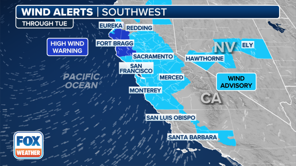
Millions of people in California are now under wind alerts through Tuesday.
A High Wind Warning is in effect for Mendocino, Lake, Humboldt and Trinity counties due to expected sustained winds of 25-35 mph, with some gusts up to 65 mph possible.
Wind Advisories remain in effect for much of Northern and Central California, including Sacramento, San Francisco and Monterey.
Sierra Nevada to be slammed with snow
Snow is expected in the higher elevations of the Sierra Nevada mountain range – and a lot of it.

“I mean, we’re talking about 1 to as much as maybe 3 feet of snow, especially in the higher elevations,” FOX Weather Meteorologist Kendall Smith said.
The snow could lead to some treacherous travel at times, and travel itself could be nearly impossible on untreated roads and highways in the area.
The snow totals will increase the higher you go in elevation.