Severe thunderstorm risk stretches from Jersey Shore to Florida
A powerful storm system that impacted the nation’s heartland as well as the Ohio and Tennessee valleys over the last two days continues to advance eastward, with much of the Eastern Seaboard under the threat for severe storms on Wednesday.
Due to atmospheric conditions not being as conducive for severe weather, chances for hail, damaging winds and tornadoes are lower than they have been over the last 48 hours.
“So, we go from a 4 out of 5 risk now to a 2 out of 5. It does mean you let off the gas pedal. You still think about what those threats can be,” said FOX Weather meteorologist Steve Bender.
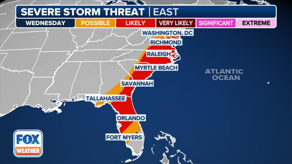
The Storm Prediction Center has highlighted communities from New Jersey to Florida for being at an increased risk of severe weather.
Included in the increased threat zone are cities such as Virginia Beach, Virginia; Raleigh, North Carolina; Charleston, South Carolina; Jacksonville, Florida; and Tampa and Orlando.

Approximately 36 million people are under threats that the FOX Forecast Center considers to be “possible” and “likely.”
Happening now
A cold front continues to march eastward, and ahead of the frontal boundary, there are plenty of showers and thunderstorms.
The storm system is fast-moving, with some cells moving eastward at more than 50 mph.

Some of the storms continue to be severe, which has triggered weather alerts to be issued for many counties.
The majority of the storms are expected to be offshore by sunset, but the wintry weather on the northern end of the storm system will linger through at least Thursday.
April is usually second-busiest month for severe weather
The fourth month of the year typically sees an increase in severe weather outbreaks as seasonal air masses clash over the eastern half of the country.

In fact, April is usually the second busiest for tornadoes, only outdone by May.
A global climate pattern known as an El Niño is known to clamp down on severe weather outbreaks in the Lower 48.
The year seems to be following the norms set during previous El Niño events.
Data from the SPC shows tornado activity for the year is below average, while hail and damaging winds reports are closer to average.