‘High risk’ severe weather outbreak could threaten millions in central US today
OKLAHOMA CITY – NOAA’s Storm Prediction Center (SPC) has raised the severe weather threat in parts of Oklahoma and Kansas to levels those states haven’t seen in years, placing millions of people in the central U.S. at a life-threatening risk of intense thunderstorms capable of producing long-track tornadoes, giant hail and hurricane-force wind gusts starting Monday afternoon and lasting well into the evening and overnight hours.
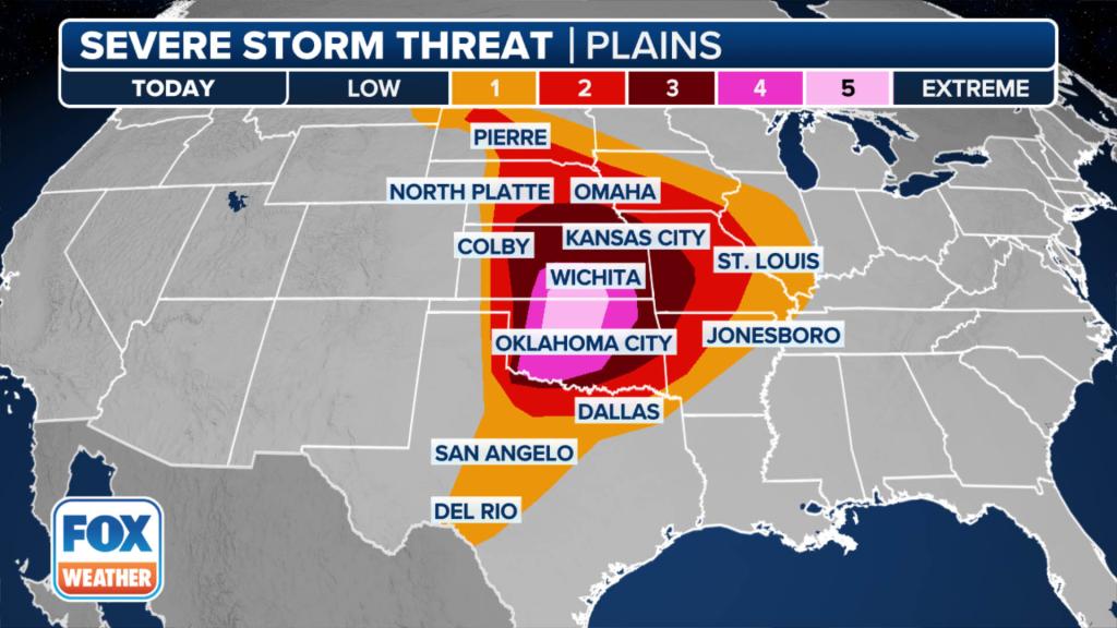
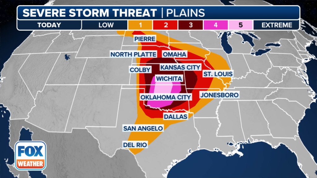
The SPC has now placed 1.6 million people in Oklahoma and Kansas in a rare “High Risk” of severe weather on Monday – the highest threat level on the SPC’s 5-point severe thunderstorm risk scale.
This includes the cities of Oklahoma City, Norman, Edmond, Midwest City and Moore in Oklahoma.
In Kansas, cities south of Wichita along the Interstate 35 corridor are also in the High Risk threat, including Wellington and South Haven.
Monday’s High Risk of severe weather is the first issued by the SPC since March 31, 2023, when an EF-4 tornado struck the community of Keota, Iowa, during a dayslong tornado outbreak that killed 31 people across six states. That was the last EF-4 tornado in the U.S. until the late-April tornado outbreak that produced a deadly EF-4 tornado in Marietta, Oklahoma.
This is now the first High Risk in Oklahoma since May 20, 2019, and the first High Risk in Kansas since May 18, 2017.

Oklahoma, Kansas included in Level 5, or ‘High Risk,’ of severe weather Monday
The SPC said numerous severe thunderstorms are expected to develop and move eastward from Monday afternoon through Monday night across parts of the southern and central Plains. Multiple intense, long-track tornadoes – especially in southern Kansas and Oklahoma – very large to giant hail between 2 and 4 inches and damaging wind gusts as high as 80 mph are all expected.
“We could see some large storms developing,” FOX Weather Meteorologist Craig Herrera said. “We’ve got lots of moist air in place, daytime heating and plenty of instability. And, of course, the wind shear could be favorable for some of these major storms to develop.”

Strong tornadoes appear likely Monday
The SPC has also highlighted those same areas as being at risk of tornadoes Monday, with some of those expected to become strong (EF-2 or higher).
There is also the risk of potentially long-track tornadoes, too.
There is no hard definition of a long-track tornado, but many forecasters believe it’s a tornado that’s on the ground for 15-20 miles or more.
“So, Oklahoma City up to Wichita, these communities, even across the state, need to be on high alert, knowing where that safe place is, where the shelter is and getting there quickly,” FOX Weather Meteorologist Jane Minar said. “Having those conversations with your family this afternoon is very important.”
The SPC said “very large to giant hail” is also likely on Monday. According to the National Weather Service, giant hail is larger than 2.75 inches in diameter, which is baseball-sized or larger.
Damaging wind gusts of 60 mph or higher are also likely across the region, but areas under the greatest risk of severe weather on Monday could see winds gust into the range of a Category 1 hurricane.
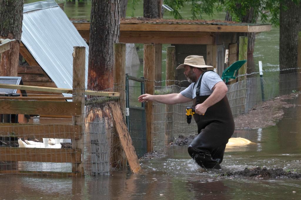
People living in areas where severe weather is likely Monday and into the middle of the week should prepare now to stay safe, including downloading the free FOX Weather app.
Severe weather threat expands east on Tuesday, Wednesday
The multiday severe weather threat will shift east on Tuesday and Wednesday, putting tens of millions of people at risk of seeing strong to severe thunderstorms.
The SPC placed more than 20 million people from the mid-South to the Ohio Valley in a Level 2 out of 5 risk on Tuesday, including major cities such as Indianapolis in Indiana, as well as Nashville in Tennessee.
According to the SPC, a line of thunderstorms is expected Tuesday morning over portions of the Midwest and mid-Mississippi Valley in association with the storms expected to slam the Plains on Monday.
That line of storms early Tuesday is expected to weaken some during the morning hours but could still bring high wind gusts to those areas.
As the day continues, scattered strong to severe thunderstorms will push off into the Ohio Valley during the afternoon hours.
The main threats from those storms will be hail and damaging wind gusts, according to the SPC.
The severe weather threat will ramp up again on Wednesday, with the SPC placing more than 21 million people from Texas to Ohio in a Level 3 out of 5 risk of severe weather.
This includes the cities of Indianapolis, Memphis in Tennessee, St. Louis in Missouri and Cincinnati in Ohio.