Weather
Another Winter Storm Headed To NJ: Latest Forecast
The rain coupled with snow melt and high winds could bring the possibility of major flooding in rivers and coastal flooding in New Jersey.

Latest update: Gov. Phil Murphy declared a state of emergency in the Garden State Monday afternoon ahead of a winter storm system. Read more.
NEW JERSEY — The Garden State is bracing for another storm on the heels of a weekend winter blast and this new system is expected to drop excessive rain leading to significant flooding.
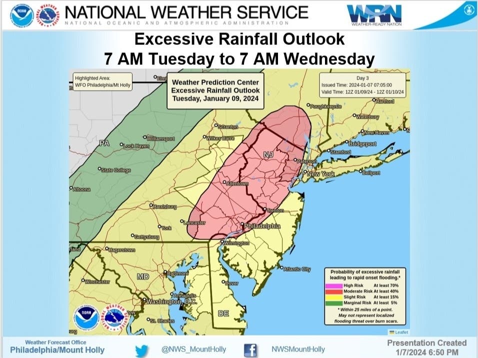
The National Weather Service(NWS) issued a Flood Watch for the entire state that will begin on Tuesday night and continue through Wednesday night.
Find out what's happening in Across New Jerseywith free, real-time updates from Patch.
"This is likely to be quite an impactful event with significant flooding possible... both freshwater flooding due to heavy rains and coastal flooding due to very strong south/southeast winds late day Tuesday and Tuesday night," according to US National Weather Service Philadelphia/Mount Holly.
A High Wind Watch has also been issued for New Jersey counties along the coast as they could see gusts over 60 mph. Inland gusts will likely be at least 40 to 50 mph.
Find out what's happening in Across New Jerseywith free, real-time updates from Patch.
"This could lead to numerous power outages," said NWS.

The "massive" winter storm is expected to roll in during the latter part of Tuesday and continue into Wednesday. Heavy rain will fall with 1 to 3 inches expected and up to 4 inches possible in some areas.
Couple that with snow melt and moderate to major river flooding is possible.
"In portions of the Northeast, where heavy snow from the storm the past weekend is on the ground, surging warm air, heavy rain and strong snow-eating winds will lead to a rapid runoff from Tuesday to Wednesday. Small streams and rivers will be on the rise with the potential for a serious flash flood event," according to AccuWeather.

Let's take a look at the forecast ahead:
North Jersey
Monday: Sunny, with a high near 38. Northwest wind 5 to 10 mph.
Monday Night: Increasing clouds, with a low around 23. West wind around 5 mph becoming calm.
Tuesday: A chance of rain and snow between 10 a.m. and 1 p.m., then rain. High near 43. Southeast wind 5 to 10 mph increasing to 10 to 15 mph in the afternoon. Winds could gust as high as 30 mph. Chance of precipitation is 90 percent. Little or no snow accumulation expected.
Tuesday Night: Rain. The rain could be heavy at times. Low around 41. Breezy, with a southeast wind 20 to 25 mph becoming south after midnight. Winds could gust as high as 40 mph. Chance of precipitation is 100 percent. New precipitation amounts between 2 and 3 inches possible.
Wednesday: Rain before 7 a.m., then a slight chance of showers between 7 a.m. and 1 p.m. High near 47. Breezy, with a southwest wind 15 to 20 mph, with gusts as high as 35 mph. Chance of precipitation is 80 percent. New precipitation amounts of less than a tenth of an inch possible.
Wednesday Night: Partly cloudy, with a low around 31.
Central Jersey
Monday: Sunny, with a high near 42. Northwest wind 5 to 10 mph.
Monday Night: Increasing clouds, with a low around 23. Calm wind.
Tuesday: Rain, mainly after 1 p.m. High near 48. East wind 5 to 10 mph increasing to 10 to 15 mph in the afternoon. Winds could gust as high as 25 mph. Chance of precipitation is 90 percent. New precipitation amounts between a half and three quarters of an inch possible.
Tuesday Night: Rain. The rain could be heavy at times. Low around 45. Breezy, with a southeast wind 20 to 25 mph becoming south after midnight. Winds could gust as high as 40 mph. Chance of precipitation is 100 percent. New precipitation amounts between 1 and 2 inches possible.
Wednesday: Rain before 7 a.m., then a slight chance of showers between 7 a.m. and 1 p.m. High near 50. Breezy, with a southwest wind 15 to 25 mph, with gusts as high as 35 mph. Chance of precipitation is 80 percent. New precipitation amounts of less than a tenth of an inch possible.
Wednesday Night: Mostly clear, with a low around 32.
South Jersey
Monday: Sunny, with a high near 43. Northwest wind 5 to 10 mph.
Monday Night: Mostly clear, with a low around 28. Northwest wind around 5 mph becoming calm.
Tuesday: Rain, mainly after 1 p.m. High near 50. Breezy, with a southeast wind 10 to 15 mph increasing to 15 to 20 mph in the afternoon. Winds could gust as high as 30 mph. Chance of precipitation is 80 percent. New precipitation amounts between a quarter and half of an inch possible.
Tuesday Night: Rain. The rain could be heavy at times. Low around 46. Very windy, with a southeast wind 35 to 45 mph decreasing to 25 to 35 mph. Winds could gust as high as 60 mph. Chance of precipitation is 100 percent. New precipitation amounts between 1 and 2 inches possible.
Wednesday: Rain likely before 7 a.m., then a slight chance of showers between 7 a.m. and 1 p.m. Partly sunny, with a high near 52. Breezy, with a west wind 15 to 25 mph, with gusts as high as 35 mph. Chance of precipitation is 60 percent. New precipitation amounts of less than a tenth of an inch possible.
Wednesday Night: Mostly clear, with a low around 31.
Get more local news delivered straight to your inbox. Sign up for free Patch newsletters and alerts.