Weather
Floods, Wind Damage, Flash Freeze Plague NJ's Christmas Travel
Friday night could be 'one of the most brutally cold nights we`ve seen in a long time,' the National Weather Service said.

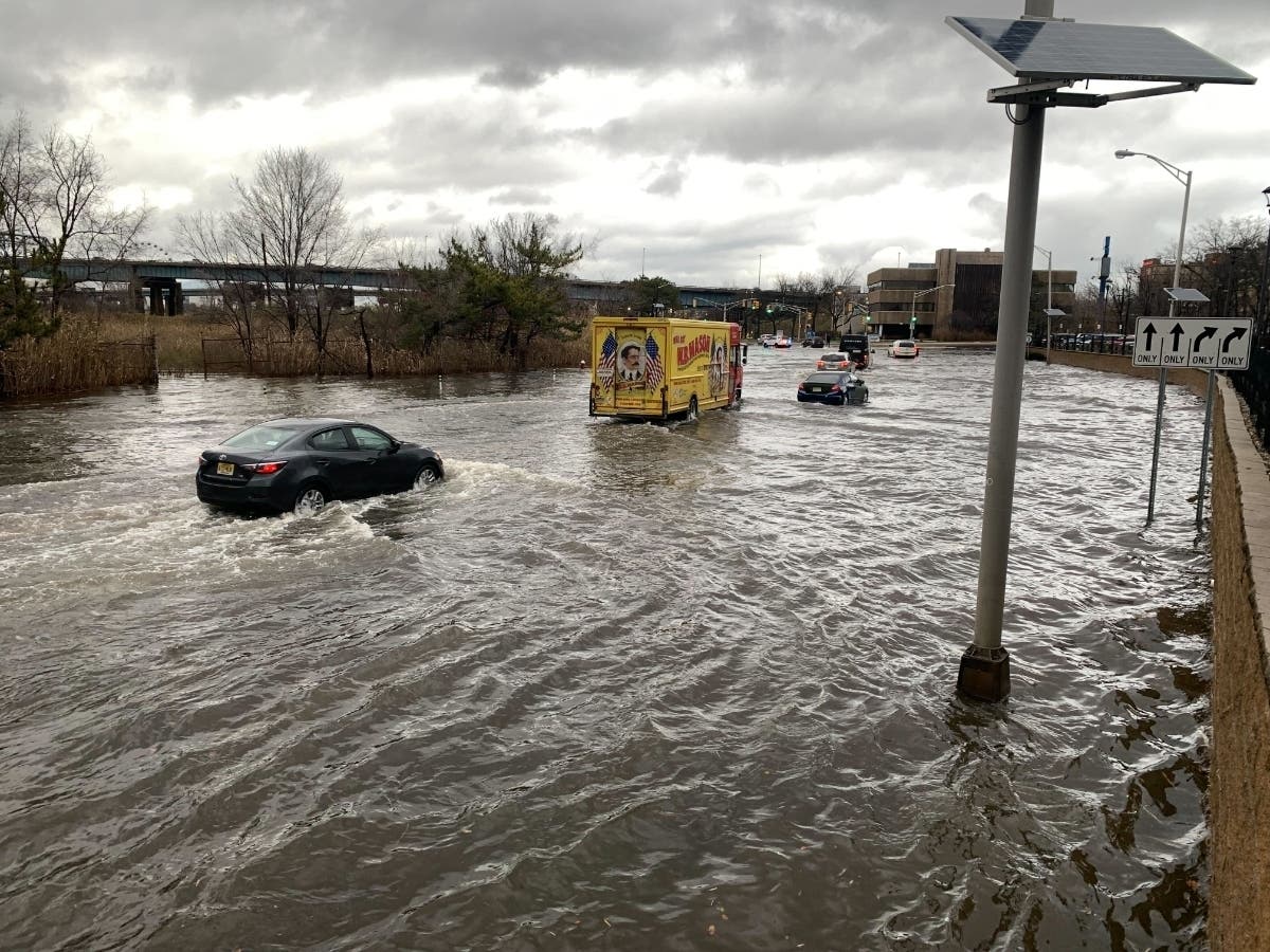
NEW JERSEY — The winter storm wreaking havoc on holiday travel has reached New Jersey. Forecasters expect a Friday filled with heavy rain, floods, a cold front icing up the roads, and winds that could cause power outages.
AccuWeather gave New Jersey a "poor" travel outlook for Friday and a fair outlook for Saturday. Any rain or wet snow that falls could rapidly freeze, while the rain may significantly reduce visibility, the weather platform says. The winter storm could cause major airline delays and a large number of flight cancelations throughout the nation, AccuWeather warns.
.jpg)
The New Jersey Department of Transportation issued commercial-vehicle travel restrictions, which began Friday morning. The restrictions will last until further notice and apply to both directions on the following highways: Interstates 76, 78, 80, 195, 280, 287, 295, 676 and Route 440 (both directions from the Outerbridge Crossing to I-287).
Find out what's happening in Across New Jerseywith free, real-time updates from Patch.
Precipitation will taper off by Friday evening, according to forecasters. But with wind chills near or below -10, Friday night "looks to be one of the most brutally cold nights we've seen in a long time, quite a few years for sure," said a forecast discussion from the National Weather Service's Mount Holly office.
Flooding rains and downed trees have already impacted New Jersey roads as of Friday morning. Additionally, coastal-flood warnings along New Jersey's coastline remain in effect until noon Friday. The National Weather Service warned of 1-2 feet of inundation above ground level in low-lying areas near shorelines and tidal waterways during that time.
Find out what's happening in Across New Jerseywith free, real-time updates from Patch.
Widespread winds will gust 40-50 mph throughout Friday, hitting 50-60 mph in some areas, the National Weather Service says. The strongest gusts increase the potential for wind damage and power outages.
The arctic front will enter New Jersey on Friday morning, clearing the coast by early afternoon, according to weather officials. Rain could change to snow before tapering off, the National Weather Service says.

In some cases, temperatures will plummet 30-50 degrees Friday, AccuWeather says. For instance, Philadelphia temperatures may go from the upper 50s on Friday morning to the 20s in the evening, according to the weather platform.
The bitter cold will continue through the weekend, with Saturday being the coldest of the two days, the National Weather Service says. Saturday temperatures will struggle to reach the 20s, with sustained winds of 15-25 mph and gusts peaking at 35 mph. Temperatures will get 5-10 degrees milder Sunday, with winds getting a bit slower, forecasters say.
.jpg)
Here's the National Weather Service's latest North Jersey forecast:
- Friday: Rain showers before 1 p.m., then a chance of snow showers between 1 p.m. and 3 p.m. Temperature falling to around 19 by 5 p.m. Wind chill values between zero and 10. Breezy, with a west wind 21 to 25 mph, with gusts as high as 46 mph. Chance of precipitation is 100 percent. Little or no snow accumulation expected.
- Friday night: Partly cloudy, with a low around 10. Wind chill values between -5 and 5. Breezy, with a west wind 17 to 24 mph, with gusts as high as 39 mph.
- Saturday: Mostly sunny and cold, with a high near 20. Wind chill values between -5 and 5. Breezy, with a west wind 16 to 20 mph, with gusts as high as 30 mph.
- Saturday night: Mostly clear, with a low around 14. Wind chill values between zero and 5. West wind 13 to 15 mph.
- Sunday (Christmas): Sunny, with a high near 27. West wind 13 to 15 mph, with gusts as high as 26 mph.
- Sunday night: Mostly clear, with a low around 17.
- Monday: Sunny, with a high near 31.
Here's the agency's latest South Jersey forecast:
- Friday: Rain before 1 p.m., then a slight chance of snow between 1 p.m. and 2 p.m. Temperature falling to around 23 by 5 p.m. Windy, with a south wind 25 to 30 mph becoming west in the afternoon. Winds could gust as high as 55 mph. Chance of precipitation is 80 percent. Little or no snow accumulation expected.
- Friday night: Mostly cloudy, with a low around 11. Wind chill values as low as -7. Windy, with a west wind 20 to 30 mph, with gusts as high as 40 mph.
- Saturday: Partly sunny, with a high near 22. Wind chill values as low as -5. Breezy, with a west wind around 20 mph, with gusts as high as 30 mph.
- Saturday night: Partly cloudy, with a low around 17. West wind around 15 mph, with gusts as high as 25 mph.
- Sunday (Christmas): Mostly sunny, with a high near 28. Breezy, with a west wind 15 to 20 mph.
- Sunday night: Mostly clear, with a low around 18.
- Monday: Mostly sunny, with a high near 31.
Get more local news delivered straight to your inbox. Sign up for free Patch newsletters and alerts.