Western Oregon WeT DRy model (WOWTDR)
Internal Tool Developers: Jonathan Burnett, Sherri Johnson, Steve Wondzell
External Tool Authors: Dunham, Jason (U.S. Geological Survey); Jaeger, Kris (U.S. Geological Survey); Brown, Mike (USDI Bureau of Land Management)
Description
The Western Oregon WeT DRy (WOWTDR) model predicts flow permanence in stream reaches using data collected via the FLOw PERmanence (FLOwPER) mobile application. The WOWTDR model and FLOwPer app were both developed as part of the Western Oregon Streamflow Permanence Project.

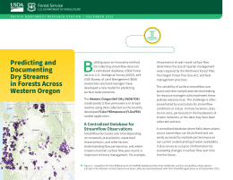
Figure 1: A map showing some of the more than 9,000 field sites where late summer streamflow data have been collected using the FLOw PERmanence mobile application as of September 2022.
The project’s goal is to improve understanding of streamflow permanence in forested headwater streams by 1) providing a framework for simple, standardized data collection of observations of surface water presence and a system for easy archiving in a centralized database, and 2) using the latest digital mapping and modeling technologies to provide predictions on the presence of late summer surface flow of headwater streams in western Oregon.
Key links for WOWTDR model
- WOWTDR Dashboard (Provisional version)
- Informational Handout (PDF 593 KB)
- WOWTDR Data Release – Early 2023
- WOWTDR Manuscript – Early 2023
Purpose and Scope
The WOWTDR model predicts the late summer streamflow status of individual stream reaches as either “wet’ or “dry.” This project has been designed for streams across western Oregon, and the approach can be extended to any area with FLOw PERmanence (FLOwPER) stream observations and high-resolution hydrography derived from LiDAR data (fig. 1). In addition to classifying flow status, with wet corresponding to locations that are predicted to have surface flow throughout the late summer and dry corresponding to locations that are predicted to have dry channel conditions at some point during the late summer (fig. 2). The model estimates classification uncertainty and can thus help target field collection surveys to fill specific knowledge gaps. These field observation campaigns will help validate the current model and improve future iterations of the WOWTDR model by expanding the FLOwPER database. These predictions can provide a region-wide view of late summer surface-water presence at a fine grain (<10 m) and can be used to support forest planning at multiple scales and inform decisions, such as the retention and size of forested buffers along streams.
Methods

Figure 2: Example map of flow status predictions for an Oregon sub-watershed using the Western Oregon WeT DRy model: orange = stream reaches with no surface flow in late summer; blue = reaches with year-round surface flow; yellow = reaches with uncertain surface flow (predictions were outside the 95 percent confidence interval); black = larger streams not modeled and expected to have year-round flow, or channels in very small watersheds not captured in training data.
The model predicts the likelihood that each 5- to 7-m long stream reach is wet or dry in late summer. It has been developed using data collected from 2019 through 2021, and the predicted flow status shown on this dashboard is based on the mean wet/dry likelihood over this 3-year period. The model is based on the Random Forest machine learning algorithm trained to eight prediction variables and more than 2,600 observations drawn from the FLOwPER database. The prediction variables, in decreasing order of importance, are total annual precipitation, Strahler stream order (i.e., the relative size of an individual stream in a stream network), total August precipitation, elevation, drainage area, downstream channel slope greater than 20 m, slope of the individual reach, and total upstream channel length.
Most FLOwPER observations used in the model were collected on small streams in 141 12-digit hydrologic unit code (HUC12) watersheds (ranging in size from 40 to 160 km2) in western Oregon. WOWTDR predictions are currently limited to the 380 HUC12 watersheds that have curated LiDAR-derived flowline hydrography within the National Hydrographic Dataset (NHD) database (published 1 September 2021). We anticipate being able to extend predictions for an additional 350 watersheds in late 2023 as LiDAR-derived hydrography becomes available for those areas.
Implementation
As might be expected, WOWTDR model predictive performance is higher in watersheds that have training data than in watersheds where such field observations have not yet been made. WOWTDR predictive performance in watersheds having training data is higher than NHD for intermittency (FCode), or on reaches classified as wet or dry.
WOWTDR predictions of wet and dry are representative of perennial and nonperennial streams under the assumption that streams that are wet in the late summer low-flow period are perennial. WOWTDR predictions and associated levels of certainty help inform where additional late summer low-flow observations would be useful. For example, field validation surveys might focus on areas where predictions are ambiguous and areas where the WOWTDR model disagrees with FCode. Additional surveys could improve WOWTDR predictions by collecting FLOwPER low-flow observations on reaches where the model is extrapolating from data collected in other locales.
Prediction data are provided via a WOWTDR dashboard for quick viewing and provide the ability to print GeoPDFs for use on mobile devices in support of field campaigns. Geodatabases of the model predictions and training data will be hosted in the USDA Forest Service Research Data Archive (mid 2023).
For more information visit Western Oregon Streamflow Permanence Project.
Partners: U.S. Geological Survey; USDI Bureau of Land Management; Oregon State University; Portland Water Bureau; USDA Forest Service, Pacific Northwest Region; Oak Ridge Institute for Science and Education; Oregon State University Aerial Information Systems Lab
Data and Tools
-
Tool

Internal Tool Developers
-
Person

Jonathan Burnett
Research Forester -
Person

Sherri Johnson
Research Ecologist -
Person

Steve Wondzell
Research Ecologist