Volcano Watch: Cruising Chain of Craters Road: Recent earthquakes and past volcanism

The upper East Rift Zone (UERZ) of Kilauea was a shaky place this past weekend. This region extends southeast from Kaluapele (Kilauea’s summit caldera) to Maunaulu, and earthquakes here can reflect pressurization of Kilauea’s summit magma storage system.
Between June 27 and July 1, the USGS Hawaiian Volcano Observatory (HVO) detected nearly 1,500 earthquakes beneath the UERZ. Activity peaked during the late evening of Saturday, June 29, when more than 30 earthquakes happened per hour. Activity slowly decreased on Sunday and returned to pre-swarm levels on Monday, July 1.
Most earthquakes in this swarm were smaller than magnitude-2, but there were several large enough to be felt by neighboring communities, including five earthquakes magnitude-3 or higher. The earthquakes stayed at depths of 1–4 km (0.6–2.5 mi) below the ground surface and were not accompanied by any significant changes in ground deformation.
Although the earthquakes were located beneath the UERZ, there were no indications that magma was moving toward the surface to possibly erupt in this area. This swarm was likely related to the buildup of pressure beneath Kilauea’s summit, as magma accumulates in underground storage system. Similar seismic swarms beneath the UERZ were observed earlier this year, in April and May, when magma was accumulating and pressurizing the summit before the last eruption on June 3. In those cases, seismic unrest moved away from the UERZ and became focused at other locations south of Kaluapele and toward the Southwest Rift Zone prior to that eruption.
However, eruptions have occurred along the UERZ in the past. There have been approximately 50 intrusions and 5 eruptions in the UERZ over the past 60 years; the most recent eruption was 45 years ago.
Chain of Craters Road in Hawaii Volcanoes National Park follows the path of the UERZ. As you turn left off Crater Rim Drive onto Chain of Craters Road, you pass by craters, thermal areas, and lava flows that showcase past volcanic activity in this area.
Luamanu Crater is first, and here you are still technically in Kilauea caldera, marked by outer faults that parallel the modern topographic extent of Kaluapele. At this location, you also drive past lava flows that erupted over three days in July of 1974. This eruption began in Keanakako‘i Crater, and vents extended northwest into the modern caldera and southeast to Luamanu Crater; lava flows covered the eastern part of the modern caldera floor and traveled to the southeast, covering part of Chain of Craters Road.
As you continue driving, you pass Puhimau, Ko‘oko‘olau, Devil’s Throat, Hi‘iaka, and Pauahi craters. Based on the age of the surrounding lava flows, we know that these craters formed within the past 750 years. In each case, void space beneath the ground surface resulted in a crater forming by collapse.
Between Puhimau and Ko‘oko‘olau craters, you’ll drive through a large area where rising steam and broomsedge grass contrasts with the surrounding ‘ohi‘a forest. This is the Puhimau thermal area. In the 1930s, earthquake swarms occurred, the ground cracked, and vegetation began to die. Since then, the soil has remained hot and the area has grown to about 50 acres (0.2 sq km). Geophysical studies show that magma is present just a few hundred meters (around 1,000 ft) beneath the ground surface.
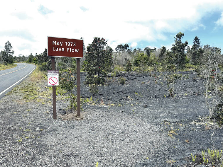
Near Hi‘iaka crater, you’ll drive through lava flows from a 7-hour eruption in May 1973. Shortly after, you’ll drive through the youngest UERZ lava flows that erupted over a day in November 1979 in and near Pauahi Crater. Other eruptions in this area were in November 1973 (29 days long) and August 1968 (5 days long).
From there, the rift zone turns east toward the cape of Kumukahi (the Island of Hawaii’s easternmost point). Now, the prominent Maunaulu lava shield will be visible as Chain of Craters Road passes through Maunaulu lava flows. Maunaulu was active from 1969–1971 and, after a three and a half month pause, from 1972–1974.
The recent UERZ earthquake swarm was likely related to increasing pressurization of the magmatic system underlying Kilauea summit, but we know based on our drive down Chain of Craters Road that magma does sometimes erupt in this area. Kilauea’s summit continues to inflate following the brief June 3 eruption and HVO will continue to closely monitor for signs of change.
Volcano Activity Updates
Kilauea is not erupting. Its USGS Volcano Alert level is ADVISORY.
Over the past week, more than 1,600 events occurred beneath Kilauea’s summit region and extending southeast into the upper East Rift Zone. Most events were smaller than M2 and occurred during the June 27-July 1 swarm beneath the upper East Rift Zone. Inflationary ground deformation has continued in the summit region following the June 3 eruption, indicating that magma is repressurizing the storage system. Unrest may continue to wax and wane with changes to the input of magma. Currently, there are no signs of an imminent eruption, but changes can occur quickly, as can the potential for eruption. The most recent summit sulfur dioxide emission rate measured was approximately 75 tonnes per day on June 28, 2024.
Mauna Loa is not erupting. Its USGS Volcano Alert Level is at NORMAL.
Six earthquakes were reported felt in the Hawaiian Islands during the past week: a M2.9 earthquake 6 km (3.7 mi) SSE of Volcano at 1.5 km (1 mi) depth on July 1 at 5:39 a.m. HST, a M3.2 earthquake 6 km (3 mi) S of Volcano at 0 km (0 mi) depth on June 30 at 3:31 p.m. HST, a M3.0 earthquake 7 km (4 mi) S of Volcano at 1 km (0.5 mi) depth on June 29 at 11:27 p.m. HST, a M2.7 earthquake 7 km (7 mi) S of Volcano at 2 km (1 mi) depth on June 29 at 8:55 p.m. HST, a M3.4 earthquake 6 km (4 mi) S of Volcano at 2 km (1 mi) depth on June 27 at 3:35 p.m. HST, and a M2.9 earthquake 6 km (4 mi) SSW of Volcano at 2 km (1 mi) depth on June 27 at 3:32 p.m. HST.
HVO continues to closely monitor Kilauea and Mauna Loa.
Please visit HVO’s website for past Volcano Watch articles, Kilauea and Mauna Loa updates, volcano photos, maps, recent earthquake information, and more. Email questions to [email protected].
Volcano Watch is a weekly article and activity update written by U.S. Geological Survey Hawaiian Volcano Observatory scientists and affiliates.