The World Portal


The world is the totality of entities, the whole of reality, or everything that exists. The nature of the world has been conceptualized differently in different fields. Some conceptions see the world as unique while others talk of a "plurality of worlds". Some treat the world as one simple object while others analyze the world as a complex made up of parts.
In scientific cosmology, the world or universe is commonly defined as "[t]he totality of all space and time; all that is, has been, and will be". Theories of modality talk of possible worlds as complete and consistent ways how things could have been. Phenomenology, starting from the horizon of co-given objects present in the periphery of every experience, defines the world as the biggest horizon or the "horizon of all horizons". In philosophy of mind, the world is contrasted with the mind as that which is represented by the mind. Theology conceptualizes the world in relation to God, for example, as God's creation, as identical to God or as the two being interdependent. In religions, there is a tendency to downgrade the material or sensory world in favor of a spiritual world to be sought through religious practice. A comprehensive representation of the world and our place in it, as is found in religions, is known as a worldview. Cosmogony is the field that studies the origin or creation of the world while eschatology refers to the science or doctrine of the last things or of the end of the world.
In various contexts, the term "world" takes a more restricted meaning associated, for example, with the Earth and all life on it, with humanity as a whole or with an international or intercontinental scope. In this sense, world history refers to the history of humanity as a whole and world politics is the discipline of political science studying issues that transcend nations and continents. Other examples include terms such as "world religion", "world language", "world government", "world war", "world population", "world economy", or "world championship". (Full article...)
Selected articles -
-


Globalization, or globalisation (Commonwealth English; see spelling differences), is the process of interaction and integration among people, companies, and governments worldwide. The term globalization first appeared in the early 20th century (supplanting an earlier French term mondialisation), developed its current meaning sometime in the second half of the 20th century, and came into popular use in the 1990s to describe the unprecedented international connectivity of the post-Cold War world. Its origins can be traced back to 18th and 19th centuries due to advances in transportation and communications technology. This increase in global interactions has caused a growth in international trade and the exchange of ideas, beliefs, and culture. Globalization is primarily an economic process of interaction and integration that is associated with social and cultural aspects. However, disputes and international diplomacy are also large parts of the history of globalization, and of modern globalization.
Economically, globalization involves goods, services, data, technology, and the economic resources of capital. The expansion of global markets liberalizes the economic activities of the exchange of goods and funds. Removal of cross-border trade barriers has made the formation of global markets more feasible. Advances in transportation, like the steam locomotive, steamship, jet engine, and container ships, and developments in telecommunication infrastructure such as the telegraph, the Internet, mobile phones, and smartphones, have been major factors in globalization and have generated further interdependence of economic and cultural activities around the globe. (Full article...) -

Land management has preserved the natural characteristics of Hopetoun Falls, Australia while allowing ample access for visitors.
The natural environment or natural world encompasses all biotic and abiotic things occurring naturally, meaning in this case not artificial. The term is most often applied to Earth or some parts of Earth. This environment encompasses the interaction of all living species, climate, weather and natural resources that affect human survival and economic activity.
The concept of the natural environment can be distinguished as components:- Complete ecological units that function as natural systems without massive civilized human intervention, including all vegetation, microorganisms, soil, rocks,plateaus, mountains, the atmosphere, and natural phenomena that occur within their boundaries and their nature.
- Universal natural resources and physical phenomena that lack clear-cut boundaries, such as air, water, and climate, as well as energy, radiation, electric charge, and magnetism, not originating from civilized human actions.
In contrast to the natural environment is the built environment. Built environments are where humans have fundamentally transformed landscapes such as urban settings and agricultural land conversion, the natural environment is greatly changed into a simplified human environment. Even acts which seem less extreme, such as building a mud hut or a photovoltaic system in the desert, the modified environment becomes an artificial one. Though many animals build things to provide a better environment for themselves, they are not human, hence beaver dams, and the works of mound-building termites, are thought of as natural. (Full article...) -
Economic globalization is one of the three main dimensions of globalization commonly found in academic literature, with the two others being political globalization and cultural globalization, as well as the general term of globalization.
Economic globalization refers to the widespread international movement of goods, capital, services, technology and information. It is the increasing economic integration and interdependence of national, regional, and local economies across the world through an intensification of cross-border movement of goods, services, technologies and capital. Economic globalization primarily comprises the globalization of production, finance, markets, technology, organizational regimes, institutions, corporations, and people.
While economic globalization has been expanding since the emergence of trans-national trade, it has grown at an increased rate due to improvements in the efficiency of long-distance transportation, advances in telecommunication, the importance of information rather than physical capital in the modern economy, and by developments in science and technology. The rate of globalization has also increased under the framework of the General Agreement on Tariffs and Trade and the World Trade Organization, in which countries gradually cut down trade barriers and opened up their current accounts and capital accounts. This recent boom has been largely supported by developed economies integrating with developing countries through foreign direct investment, lowering costs of doing business, the reduction of trade barriers, and in many cases cross-border migration. (Full article...) -

The Hereford mappa mundi, a map of the world with Jerusalem at its centre
The Hereford Mappa Mundi (Latin: mappa mundi) is the largest medieval map still known to exist, depicting the known world. It is a religious rather than literal depiction, featuring heaven, hell and the path to salvation. The map is drawn in a form deriving from the T and O pattern, dating from c. 1300. It is displayed at Hereford Cathedral in Hereford, England. The map was created with the intent of its being appreciated as an intricate work of art rather than as a navigational tool. Sources for the information presented on the map include the Alexander tradition, medieval bestiaries and Monstrous races tradition, as well as the Bible.
Although the evidence is circumstantial, modern scholarship links the map with the promotion of the cult of Thomas de Cantilupe, and with a justification of the expulsion of Jewry from England. Potentially antisemitic images include a horned Moses and a depiction of Jews worshipping the Golden Calf in the form of a Saracen devil. The map also seems to reflect very patriarchical views of women as inherently sinful, including figures such as the wife of Lot being turned into a pillar of salt for gazing at the city of Sodom. Cantilupe was known for his dislike of Jews and was regarded as misogynistic even by the standards of his own time. (Full article...) -
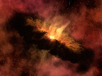
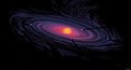
Artist's conception of a protoplanetary disk
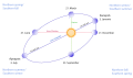
There is evidence that the formation of the Solar System began about 4.6 billion years ago with the gravitational collapse of a small part of a giant molecular cloud. Most of the collapsing mass collected in the center, forming the Sun, while the rest flattened into a protoplanetary disk out of which the planets, moons, asteroids, and other small Solar System bodies formed.
This model, known as the nebular hypothesis, was first developed in the 18th century by Emanuel Swedenborg, Immanuel Kant, and Pierre-Simon Laplace. Its subsequent development has interwoven a variety of scientific disciplines including astronomy, chemistry, geology, physics, and planetary science. Since the dawn of the Space Age in the 1950s and the discovery of exoplanets in the 1990s, the model has been both challenged and refined to account for new observations. (Full article...) -
The World Factbook, also known as the CIA World Factbook, is a reference resource produced by the Central Intelligence Agency (CIA) with almanac-style information about the countries of the world. The official print version is available from the Government Publishing Office. The Factbook is available in the form of a website that is partially updated every week. It is also available for download for use off-line. It provides a two- to three-page summary of the demographics, geography, communications, government, economy, and military of 266 international entities, including U.S.-recognized countries, dependencies, and other areas in the world.
The World Factbook is prepared by the CIA for the use of U.S. government officials, and its style, format, coverage, and content are primarily designed to meet their requirements. It is also frequently used as a resource for academic research papers and news articles. As a work of the U.S. government, it is in the public domain in the United States. (Full article...) -

A map of nations which have Lèse-majesté laws as of September 2022
Freedom of speech is the concept of the inherent human right to voice one's opinion publicly without fear of censorship or punishment. "Speech" is not limited to public speaking and is generally taken to include other forms of expression. The right is preserved in the United Nations Universal Declaration of Human Rights and is granted formal recognition by the laws of most nations. Nonetheless, the degree to which the right is upheld in practice varies greatly from one nation to another. In many nations, particularly those with authoritarian forms of government, overt government censorship is enforced. Censorship has also been claimed to occur in other forms and there are different approaches to issues such as hate speech, obscenity, and defamation laws.
The following list is partially composed of the respective countries' government claims and does not fully reflect the de facto situation, however many sections of the page do contain information about the validity of the government's claims alongside said claims. (Full article...)


General images -
-
-
 A computer-generated image mapping the prevalence of artificial satellites and space debris around Earth in geosynchronous and low Earth orbit (from Earth)
 -
 View of Earth from the Moon by the Lunar Reconnaissance Orbiter (from Earth)
 -
 Pale orange dot, an artist's impression of Early Earth, featuring its tinted orange methane-rich early atmosphere (from Earth)
 -
 Chennakesava Temple, Belur, India
 -
 Satellite time lapse imagery of Earth's rotation showing axis tilt (from Earth)
 -
 A 2012 artistic impression of the early Solar System's protoplanetary disk from which Earth and other Solar System bodies were formed (from Earth)
 -
 Cross-section through a liposome (from History of Earth)
 -
 Lithified stromatolites on the shores of Lake Thetis, Western Australia. Archean stromatolites are the first direct fossil traces of life on Earth. (from History of Earth)
 -
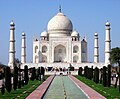 Taj Mahal, Mughal Empire, India
 -
 A map of heat flow from Earth's interior to the surface of Earth's crust, mostly along the oceanic ridges (from Earth)
 -
 A composite image of artificial light emissions at night on a map of Earth (from Earth)
 -
 An animation of the changing density of productive vegetation on land (low in brown; heavy in dark green) and phytoplankton at the ocean surface (low in purple; high in yellow) (from Earth)
 -
-

-

-
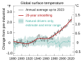 Change in average surface air temperature and drivers for that change. Human activity has caused increased temperatures, with natural forces adding some variability. (from Earth)
 -
 Graph showing range of estimated partial pressure of atmospheric oxygen through geologic time (from History of Earth)
 -
 Olmec colossal head, now at the Museo de Antropología de Xalapa
 -
 Ajloun Castle, Jordan
 -
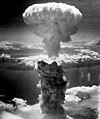
 First airplane, the Wright Flyer, flew on 17 December 1903.
 -
 13th-century French historiated initial with the three classes of medieval society: those who prayed (the clergy), those who fought (the knights), and those who worked (the peasantry) (from Human history)
 -
 Benin Bronze head from Nigeria
 -
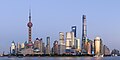 Shanghai. China urbanized rapidly in the 21st century.
 -
 Ming dynasty section, Great Wall of China
 -
 Artist's conception of Devonian flora (from History of Earth)
 -
 Great Mosque of Kairouan, Tunisia, founded 670 CE
 -
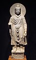 Standing Buddha from Gandhara, 2nd century CE
 -
 Artist's impression of a Hadean landscape with the relatively newly formed Moon still looming closely over Earth and both bodies sustaining strong volcanism. (from History of Earth)
 -
 An artist's impression of ice age Earth at glacial maximum. (from History of Earth)
 -
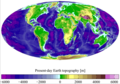
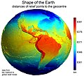 Earth's western hemisphere showing topography relative to Earth's center instead of to mean sea level, as in common topographic maps (from Earth)
 -
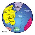 A reconstruction of Pannotia (550 Ma). (from History of Earth)
 -
 Dinosaurs were the dominant terrestrial vertebrates throughout most of the Mesozoic (from History of Earth)
 -
-
 A pillar at Göbekli Tepe
 -

-
 COVID-19 pandemic, 2020 (from Human history)
 -
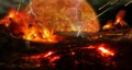
 An artist's impression of the Archean, the eon after Earth's formation, featuring round stromatolites, which are early oxygen-producing forms of life from billions of years ago. After the Late Heavy Bombardment, Earth's crust had cooled, its water-rich barren surface is marked by continents and volcanoes, with the Moon still orbiting Earth half as far as it is today, appearing 2.8 times larger and producing strong tides. (from Earth)
 -
 The replicator in virtually all known life is deoxyribonucleic acid. DNA is far more complex than the original replicator and its replication systems are highly elaborate. (from History of Earth)
 -

-

-

-
 Yggdrasil, an attempt to reconstruct the Norse world tree which connects the heavens, the world, and the underworld. (from World)
 -
 Great Pyramids of Giza, Egypt
 -
 Peopling of the world, the Southern Dispersal scenario
 -
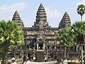 Angkor Wat temple complex, Cambodia, early 12th century
 -
The pale orange dot, an artist's impression of the early Earth which might have appeared orange through its hazy methane rich prebiotic second atmosphere. Earth's atmosphere at this stage was somewhat comparable to today's atmosphere of Titan. (from History of Earth)
-
 Artist's impression of the enormous collision that probably formed the Moon (from History of Earth)
 -
 Pangaea was a supercontinent that existed from about 300 to 180 Ma. The outlines of the modern continents and other landmasses are indicated on this map. (from History of Earth)
 -

-
 Persepolis, Achaemenid Empire, 6th century BCE
 -
 Tiktaalik, a fish with limb-like fins and a predecessor of tetrapods. Reconstruction from fossils about 375 million years old. (from History of Earth)
 -
 Fall of the Berlin Wall, 1989
 -
 A view of Earth with its global ocean and cloud cover, which dominate Earth's surface and hydrosphere; at Earth's polar regions, its hydrosphere forms larger areas of ice cover. (from Earth)
 -
 Geologic map of North America, color-coded by age. From most recent to oldest, age is indicated by yellow, green, blue, and red. The reds and pinks indicate rock from the Archean.
 -
 Empires of the world in 1898
 -
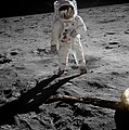
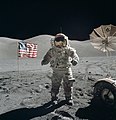 Last Moon landing: Apollo 17 (1972)
 -
 Artist's conception of Hadean Eon Earth, when it was much hotter and inhospitable to all forms of life. (from History of Earth)
 -
 A composite image of Earth, with its different types of surface discernible: Earth's surface dominating Ocean (blue), Africa with lush (green) to dry (brown) land and Earth's polar ice in the form of Antarctic sea ice (grey) covering the Antarctic or Southern Ocean and the Antarctic ice sheet (white) covering Antarctica. (from Earth)
 -
 Earth's axial tilt causing different angles of seasonal illumination at different orbital positions around the Sun (from Earth)
 -

-
 Obelisk of Axum, Ethiopia
 -
 Artist's rendition of an oxinated fully-frozen Snowball Earth with no remaining liquid surface water. (from History of Earth)
 -
 Japanese depiction of a Portuguese carrack. European maritime innovations led to proto-globalization.
 -
 Notre-Dame de Paris, France
 -
 A banded iron formation from the 3.15 Ga Moodies Group, Barberton Greenstone Belt, South Africa. Red layers represent the times when oxygen was available; gray layers were formed in anoxic circumstances. (from History of Earth)
 -
 Vitruvian Man by Leonardo da Vinci epitomizes the advances in art and science seen during the Renaissance. (from History of Earth)
 -
 A schematic view of Earth's magnetosphere with solar wind flowing from left to right (from Earth)
 -
 Image of the physical world, captured by the Hubble Space Telescope (from World)
 -
 Machu Picchu, Inca Empire, Peru
 -

-
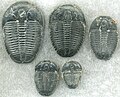 Trilobites first appeared during the Cambrian period and were among the most widespread and diverse groups of Paleozoic organisms. (from History of Earth)
 -
-
-

-
-
 Florence, birthplace of the Italian Renaissance
 -
 Earth's history with time-spans of the eons to scale (from History of Earth)
 -
 Battle during the 1281 Mongol invasion of Japan
 -
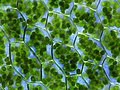 Chloroplasts in the cells of a moss (from History of Earth)
 -
 Tracy Caldwell Dyson, a NASA astronaut, observing Earth from the Cupola module at the International Space Station on 11 September 2010 (from Earth)
 -
 A view of Earth with different layers of its atmosphere visible: the troposphere with its clouds casting shadows, a band of stratospheric blue sky at the horizon, and a line of green airglow of the lower thermosphere around an altitude of 100 km, at the edge of space (from Earth)
 -
 A 580 million year old fossil of Spriggina floundensi, an animal from the Ediacaran period. Such life forms could have been ancestors to the many new forms that originated in the Cambrian Explosion. (from History of Earth)
 -
 Earth's land use for human agriculture in 2019 (from Earth)
 -
 "Lucy", the first Australopithecus afarensis skeleton found, was only 1.06 m (3 ft 6 in) tall.
 -
 Earth's night-side upper atmosphere appearing from the bottom as bands of afterglow illuminating the troposphere in orange with silhouettes of clouds, and the stratosphere in white and blue. Next the mesosphere (pink area) extends to the orange and faintly green line of the lowest airglow, at about one hundred kilometers at the edge of space and the lower edge of the thermosphere (invisible). Continuing with green and red bands of aurorae stretching over several hundred kilometers. (from Earth)
 -
 A reconstruction of human history based on fossil data. (from History of Earth)
 -
 An artist's rendering of a protoplanetary disk (from History of Earth)
 -
Artist's impression of Earth during the later Archean, the largely cooled planetary crust and water-rich barren surface, marked by volcanoes and continents, features already round microbialites. The Moon, still orbiting Earth much closer than today and still dominating Earth's sky, produced strong tides. (from History of Earth)


.jpg)


.jpg)


.jpeg)


.svg)


.jpg)


Megacities of the world -
_(cropped).jpg)
São Paulo (/ˌsaʊ ˈpaʊloʊ/) is the most populous city in Brazil and the capital of the state of São Paulo. Listed by the Globalization and World Cities Research Network (GaWC) as an alpha global city, it exerts substantial international influence in commerce, finance, arts, and entertainment. Is the largest urban area by population outside Asia and the most populous Portuguese-speaking city in the world. The city's name honors Paul the Apostle and people from the city are known as paulistanos. The city's Latin motto is Non ducor, duco, which translates as "I am not led, I lead."
Founded in 1554 by Jesuit priests, the city was the center of the bandeirantes settlers during Colonial Brazil, but it became a relevant economic force only during the Brazilian coffee cycle in the mid-19th century and later consolidated its role as the main national economic hub with industrialization in Brazil in the 20th century, which made the city a cosmopolitan melting pot, home to the largest Arab, Italian, and Japanese diasporas in the world, with ethnic neighborhoods like Bixiga, Bom Retiro, and Liberdade, and people from more than 200 other countries. The city's metropolitan area, the Greater São Paulo, is home to 20 million inhabitants and ranks as the most populous in Brazil and one of the most populous in the world. The process of conurbation between the metropolitan areas around the Greater São Paulo also created the São Paulo Macrometropolis, the first megalopolis in the Southern Hemisphere, with more than 30 million inhabitants. (Full article...)Did you know -

- ... that City Pier A's clock tower was the first memorial to World War I casualties in the United States, according to a New York City government spokesperson?
- ... that as a result of the Röhm scandal, a Nazi became the world's first openly gay politician in 1932?
- ... that Alexander Bannwart got into a fistfight with the pro-war senator Henry Cabot Lodge over America's proposed entry into World War I?
- ... that Oleksandr Kamyshin, the head of Ukrainian Railways, who runs the iron diplomacy program that brings world leaders to Kyiv by rail, carries his gun and his son's stuffed owl with him?
- ... that at the age of 82, Kuwaiti crown prince Mishal Al-Ahmad Al-Jaber Al-Sabah is the oldest heir apparent in the world?
- ... that Winston Churchill published an essay on extraterrestrial life during the Second World War?
- ... that the Te'omim Cave in Israel was home to a Bronze Age alabaster quarry, a refuge cave during the Jewish–Roman wars, and a possible center for necromantic activity in late antiquity?
- ... that Lady Eva Julius once called Girl Guiding "the most important youth movement in the world"?
Countries of the world -

The Bahamas (/bəˈhɑːməz/ bə-HAH-məz), officially the Commonwealth of The Bahamas, is an island country in the Atlantic Ocean within the Lucayan Archipelago in the Atlantic Ocean. It contains 97% of the Lucayan Archipelago's land area and 88% of its population. The archipelagic country consists of more than 3,000 islands, cays, and islets in the Atlantic Ocean, and is located north of Cuba and northwest of the island of Hispaniola (split between the Dominican Republic and Haiti) and the Turks and Caicos Islands, southeast of the U.S. state of Florida, and east of the Florida Keys. The Bahamas forms the United States' “third border,” with the island of Bimini less than 50 nautical miles from the Floridian metropolitan areas of Fort Lauderdale and Miami. The capital is Nassau on the island of New Providence. The Royal Bahamas Defence Force describes The Bahamas' territory as encompassing 470,000 km2 (180,000 sq mi) of ocean space. The continent The Bahamas are on is North America.
The Bahama islands were inhabited by the Arawak and Lucayans, a branch of the Arawakan-speaking Taíno, for many centuries. Christopher Columbus was the first European to see the islands, making his first landfall in the "New World" in 1492 when he landed on the island of San Salvador. Later, the Spanish shipped the native Lucayans to Hispaniola and enslaved them there, after which the Bahama islands were mostly deserted from 1513 until 1648, nearly all native Bahamians having been forcibly removed for enslavement or having died of diseases that Europeans brought with them from Europe. In 1649, English colonists from Bermuda, known as the Eleutheran Adventurers, settled on the island of Eleuthera. (Full article...)
The Seven Wonders of the Ancient World, also known as the Seven Wonders of the World or simply the Seven Wonders, is a list of seven notable structures present during classical antiquity. The first known list of seven wonders dates back to the 2nd–1st century BC.
While the entries have varied over the centuries, the seven traditional wonders are the Great Pyramid of Giza, the Colossus of Rhodes, the Lighthouse of Alexandria, the Mausoleum at Halicarnassus, the Temple of Artemis, the Statue of Zeus at Olympia, and the Hanging Gardens of Babylon. Using modern-day countries, two of the wonders were located in Greece, two in Turkey, two in Egypt, and one in Iraq. Of the seven wonders, only the Pyramid of Giza, which is also by far the oldest of the wonders, still remains standing, while the others have been destroyed over the centuries. There is scholarly debate over the exact nature of the Hanging Gardens, and there is doubt as to whether they existed at all. (Full article...)Related portals
Protected areas of the world -
-
Protected areas of West Bengal cover 4% of the state area. Forests make up 14% of the geographical area of West Bengal, which is lower than the national average of 33%. West Bengal has a wide variety of fauna, including Bengal tigers, Indian leopards, sloth and Himalayan black bears, chital and sambar (deer), Indian boars, pygmy hogs, Indian elephants, Indian peafowl, great Indian hornbills, Eurasian spoonbills, brahminy ducks, king and Indian cobras, white-lipped pit viper, Indian and reticulated pythons, mugger crocodiles, saltwater crocodiles, gharials, and many more. A huge montane forest, Dooars, is situated in the Northern West Bengal districts of Alipur Duar, Darjeeling, and Kalimpong. Part of the world's largest mangrove forest, Sundarbans, is located in southern West Bengal.
There are 6 national parks and 15 wildlife sanctuaries in West Bengal. (Full article...) -

Bonampak is an ancient Maya archaeological site in the Mexican state of Chiapas, and is a natural monument.
There are currently 225 Protected Natural Areas in Mexico, covering 93.8 million hectares in total. They are protected and administered by the National Commission of Protected Natural Areas (Comisión Nacional de Áreas Naturales Protegidas, or 'CONANP'), a federal agency. CONANP administers:- 77 Mexican National Parks
- 48 biosphere reserves
- 54 flora and fauna protection areas
- 28 Mexican Nature Sanctuaries
- 13 natural resources protection areas
- 5 natural monuments
-
Protected areas of Libya include any geographical area protected for a specific use.
Most protected areas are intended for the conservation of flora and fauna. Libya's national parks and nature reserves are maintained by the "Technical Committee of Wildlife and National Parks" which was created in 1990, as part of the General Secretariat of Agricultural Reclamation and Land Reform. (Full article...) -
The Protected areas of New South Wales include both terrestrial and marine protected areas. there are 225 national parks in New South Wales. A number established since the late 1970s followed campaigns by local residents and environmentalists.
Based on the Collaborative Australian Protected Area Database (CAPAD) 2020 data there are 2136 separate terrestrial protected areas with a total land area of 7,696,641 hectares (19,018,810 acres) (9.61% of the state's area). CAPAD data also shows 18 marine protected areas with a total area of 348,849 hectares (862,020 acres), covering 39.63% of NSW waters. (Full article...) -

Network of protected areas in Albania (2020)
Despite being a relatively small country, Albania is exceedingly rich in biodiversity. Its ecosystems and habitats support over 5,550 species of vascular and non-vascular plants and more than 15,600 species of coniferous and non-coniferous evergreens, most of which are threatened at global and European levels. The country has made recent efforts to expand its network of protected areas which now include: 11 national parks, 1 marine park, 718 nature monuments, 23 managed nature reserves, 11 protected landscapes, 4 World Heritage Sites, 4 Ramsar sites and other protected areas of various categories, that when combined, account for 21.36% of the territory. Furthermore, a biosphere reserve, 45 important plant areas and 16 important bird areas are found in the country.
Meanwhile, the central government has proclaimed the Coastline and the Tirana Greenbelt as areas of national importance. (Full article...) -

Map of Georgia
The protected areas of Georgia cover almost one million acres (4,000 km2) of the state. These areas are managed by different federal and state level authorities and receive varying levels of protection. Some areas are managed as wilderness while others are operated with acceptable commercial exploitation. On the Federal level, Georgia contains 1 Biosphere Reserve, 15 National Park Service Managed Sites, 1 National Forest and 8 Wildlife Refuges. Georgia is home to 63 state parks, 48 of which are state parks and 15 that are National Historic Sites, and many state wildlife preserves, under the supervision of the Georgia Department of Parks and Recreation, a division of the Georgia Department of Natural Resources. (Full article...) -

Map of protected areas of the Czech Republic: national parks (grey) and protected landscape areas (green)
There are several types of protected areas of the Czech Republic. The main form of landscape protection is delimitation of special protected areas. All the types of protected areas are determined by law. (Full article...) -
There are four categories of protected areas in India, constituted under the Wildlife Protection Act, 1972. Tiger reserves consist of areas under national parks and wildlife sanctuaries. There are 53 tiger reserves in India. the protected areas of India cover 173,629.52 square kilometres (67,038.73 sq mi), roughly 5.28% of the total geographical area of the country. (Full article...)
-
This is a list of protected areas in Bulgaria which includes 3 national parks, 11 nature parks and 55 nature reserves. The national policy for governing and management of the protected areas is implemented by the Ministry of Environment and Water. The first nature park in Bulgaria and the Balkan Peninsula is Vitosha Nature Park, established in 1934. All of the nationally protected areas in Bulgaria are also part of the Natura 2000 network of protected natural areas in the territory of the European Union. Bulgaria has some of the largest Natura 2000 areas in the European Union covering 33.8% of its territory.
- Parks and reserves in italic letters are part of Global 200 ecoregions.
-

Rano Kau, Parque National Rapa Nui, Easter Island
The protected areas of Chile are areas that have natural beauty or significant historical value protected by the government of Chile. These protected areas cover over 140,000 km2 (54,054 sq mi), which is 19% of the territory of Chile. The National System of Protected Wild Areas (SNASPE by its Spanish acronym) is regulated by law #18,362 passed in 1984, and administered by the National Forest Corporation (CONAF).
There are three types of territories: (Full article...) -
Papua New Guinea is home to several protected areas, which receive protection because of their environmental, cultural or similar value.
The total area of Papua New Guinea protected territories is 14,330 km2 (5,530 sq mi), which amounts to approximately 3.07% of the country's territory. The total number of protected areas as 2018 is 71. (Full article...) -

Rock carvings at the Ewaninga Rock Carvings Conservation Reserve
The protected areas of the Northern Territory consists of protected areas managed by the governments of the Northern Territory and Australia and private organisations with a reported total area of 335,527 square kilometres (129,548 sq mi) being 24.8% of the total area of the Northern Territory of Australia. (Full article...) -

Viru bog in Lahemaa National Park
Protected areas in Estonia are national parks, nature reserves and landscape protection areas (nature parks).
Estonia has five national parks, 167 nature reserves and 152 landscape conservation areas. In addition, there are 116 (118) protected areas with an old (Soviet-era) protection regulation and 537 parks. In total, 18.1% of Estonia are protected nature areas, with Lääne County having the highest percentage (32%) and Põlva County the lowest percentage of protected areas, about 9%. (Full article...) -
-
Protected areas of Turkmenistan include nine nature reserves (zapovednik) and 13 sanctuaries (zakaznik) with a total area of 19,750 km2 or more than 4% of Turkmenistan's territory. (Full article...)

.svg)


Selected world maps
-
 The Goode homolosine projection is a pseudocylindrical, equal-area, composite map projection used for world maps.
 -
 1516 map of the world by Martin Waldseemüller
 -
 Index map from the International Map of the World (1:1,000,000 scale)
 -
 Time zones of the world
 -
 United Nations Human Development Index map by country (2016)
 -
 The world map by Gerardus Mercator (1569), the first map in the well-known Mercator projection
 -
 Mollweide projection of the world
 -
 Only a few of the largest large igneous provinces appear (coloured dark purple) on this geological map, which depicts crustal geologic provinces as seen in seismic refraction data
 -
 A plate tectonics map with volcano locations indicated with red circles


World records
- List of Olympic records in athletics
- List of world records in athletics
- List of junior world records in athletics
- List of world records in masters athletics
- List of world youth bests in athletics
- List of IPC world records in athletics
- List of world records in canoeing
- List of world records in chess
- List of cycling records
- List of world records in track cycling
- List of world records in finswimming
- List of world records in juggling
- List of world records in rowing
- List of world records in speed skating
- List of world records in swimming
- List of IPC world records in swimming
- List of world records in Olympic weightlifting
Topics

Continents of Earth | ||||||||
|---|---|---|---|---|---|---|---|---|
| ||||||||
| ||||||||
| ||||||||


| Cenozoic Era (present–66.0 Ma) |
| ||||||||||||
|---|---|---|---|---|---|---|---|---|---|---|---|---|---|
| Mesozoic Era (66.0–252 Ma) |
| ||||||||||||
| Paleozoic Era (252–539 Ma) |
| ||||||||||||
| Proterozoic Eon (539 Ma–2.5 Ga) |
| ||||||||||||
| Archean Eon (2.5–4 Ga) | |||||||||||||
| Hadean Eon (4–4.6 Ga) | |||||||||||||
ka = kiloannum (thousands years ago); Ma = megaannum (millions years ago); Ga = gigaannum (billions years ago). See also: Geologic time scale • | |||||||||||||
| Locations | ||
|---|---|---|
| Related | ||

| |||||||||||||||||||
| |||||||||||||||||||
| |||||||||||||||||||

Economic classification of countries | |||||
|---|---|---|---|---|---|
| Three-World Model | |||||
| Gross domestic product (GDP) |
| ||||
| Gross national income (GNI) | |||||
| Wages | |||||
| Wealth | |||||
| Other national accounts | |||||
| Human development | |||||
| Digital divide | |||||
| Net international investment position (NIIP) | |||||
| Technological |
| ||||
|---|---|---|---|---|---|
| Sociological | |||||
| Ecological |
| ||||
| Biological |
| ||||
| Astronomical | |||||
| Eschatological |
| ||||
| Others |
| ||||
| Fictional | |||||
| Organizations | |||||
Categories

Wikimedia
The following Wikimedia Foundation sister projects provide more on this subject:
-
 Commons
Free media repository -
 Wikibooks
Free textbooks and manuals -
 Wikidata
Free knowledge base -
 Wikinews
Free-content news -
 Wikiquote
Collection of quotations -
 Wikisource
Free-content library -
 Wikispecies
Directory of species -
 Wikiversity
Free learning tools -
 Wikivoyage
Free travel guide -
 Wiktionary
Dictionary and thesaurus


