
CHAPTER 4. CASE STUDIES
INTRODUCTION
This chapter summarizes three case studies that practitioners recommended as part of the survey. The three case studies are as follows:
| State | Project | Status | Construction Cost |
|---|---|---|---|
| Colorado | Bridge reconstruction and new pedestrian bridge construction on State Highway 82 (SH 82) | Completed in November 2017. | $150 million |
| Texas | Highway widening project on US 281: Segment 1 (Loop 1604 to Stone Oak) Segment 2 (Stone Oak to Bexar County Line) | Segment 1 was completed in August 2021. Phase 2 is nearing completion. | $349 million |
| Virginia | Hillsboro Improvement Project | Completed (May 2021). | $15 million |
COLORADO—SH 82 BRIDGE RECONSTRUCTION AND NEW PEDESTRIAN BRIDGE CONSTRUCTION
Project Overview
The Grand Avenue Bridge Replacement project involved replacing and realigning the existing bridge on SH 82 over a railroad track, the Colorado River, and Interstate (I) 70 in Glenwood Springs (Figure 16). Initial work included construction of platforms (also called causeways) at the pier locations on the south bank of the Colorado River. Crews then installed a temporary walkway on the existing SH 82 vehicular bridge, followed by the removal of the pedestrian bridge and replacement with a new one that could carry existing utility facilities. (Note: the utility facilities were attached to the old vehicular bridge.) Work then focused on the construction of a new vehicular bridge. Traffic on the existing bridge was maintained until the fall of 2017, after which the bridge was closed, and traffic was rerouted while the new vehicular bridge was under construction.
The old Grand Avenue Bridge was built in 1953 as a two-lane bridge with a sidewalk on each side. The sidewalks were removed in 1969 to make way for two additional travel lanes. A pedestrian bridge was subsequently built. In 2009, the Colorado state legislature passed a bill to fund a program (called the Colorado Bridge Enterprise program) to address the state’s poorly rated bridges. The Grand Avenue Bridge was one of approximately 150 bridges on the state system that had a poor rating and therefore had priority for the funding. Work on an environmental assessment for the project began in summer 2011 after a CDOT study found the bridge to have functional, structural, and safety deficiencies. The final budget for the project was $126 million, which included contributions from the state and contributions from utility owners and several local governments, including the city of Glenwood Springs, Garfield County, and Eagle County.

OpenStreetMap© (https://www.openstreetmap.org/copyright)
The existing bridge consisted of nine spans with three steel units of concrete pier foundations. It had insufficient vertical and horizontal clearances, as well as narrow 9-ft 4-in lanes with no shoulders. The deck and girders did not meet current design standards. Replacement of the bridge widened the existing lanes and improved the load of the deck and girders. The project included a five-leg roundabout at the 6th Street and Laurel Street intersection to optimize traffic circulation between I 70, SH 82, 6th Street, and Laurel Street.
The existing pedestrian bridge was not included in the original project scope and therefore was not included in the environmental review. One of the reasons was that the pedestrian bridge had been renovated recently. Prior to the environmental review, the original project scope included a vehicular bridge replacement using the original alignment, with minimum anticipated right-of-way and utility relocation issues. As the preliminary design progressed, it became clear that addressing current and future pedestrian and bicyclist needs would be critical. It also became clear that the utility attachments to the existing vehicular bridge would constitute a major challenge during the construction phase. A recommended alternative was to use the pedestrian bridge to facilitate the relocation of existing utility facilities that were attached to the vehicular bridge. However, the existing pedestrian bridge did not have the capacity to hold these facilities, which made it necessary to include replacing the pedestrian bridge as one of the design options.
CDOT followed a context sensitive solutions approach for the development of the project. This approach involved participation by a wide range of stakeholders to preserve scenic, aesthetic, historic, and environmental resources, while ensuring safety and mobility.
CDOT selected a construction manager/general contractor (CM/GC) project delivery method for the SH 82 project. CDOT had used a CM/GC approach on another bridge project successfully and decided that using the approach for the SH 82 project would add value to the project. The CM/GC contractor’s involvement started early during the concept development phase to help the development team brainstorm ideas on how to minimize construction time and impacts to Glenwood Springs. The CM/GC contractor’s participation was also critical as the project transitioned from pre-construction to construction to help keep institutional memory and manage risks.
Significant construction milestones included the following:
- March 2016: Construction of the south causeway was complete. Temporary pedestrian walkway on vehicular bridge opened.
- April 2016: Demolition of the existing pedestrian bridge.
- March 2017: New pedestrian bridge opened for public use.
- August 2017: Construction of the north causeway along the Colorado River was complete.
- August 2017: Traffic bridge detour/closure.
- December 2017: New Grand Avenue bridge was completed. Completion of 6th and Laurel roundabout. Completion of River Street. Completion of SH 82 and I 70 exits.
- February 2018: Completion of Glenwood Hot Springs lot.
- March 2018: Causeway removal complete.
- June 2018: Landscaping finalized.
Management of Utilities
As mentioned, the new pedestrian bridge was designed to carry the existing utility facilities that were attached to the old vehicular bridge. The utility relocation design involved converging all existing lines into a vault, and then elbowing up to the underside of the pedestrian bridge. Four utility owners agreed to contribute a total of $3 million toward the construction of the new pedestrian bridge, with the relocated utility facilities accommodated on the new bridge via permit.
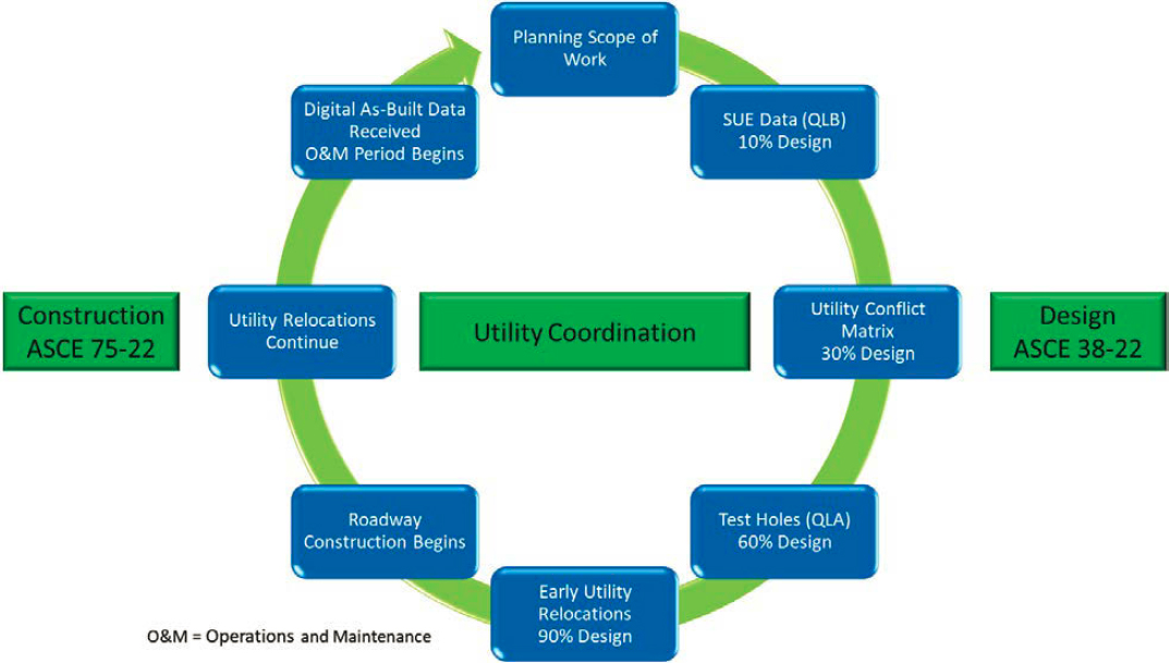
The SH 82 project was complex from a utility coordination perspective. To reduce the risk of delays during construction, it became clear that the existing utility facilities that were attached to the existing vehicular bridge would need to be relocated during the first phase of the project. To facilitate the utility coordination process, CDOT implemented a utility engineering-based program that included early utility investigations during project deliveries, early identification and resolution of conflicts, and frequent coordination with utility owners. Based on the positive results that CDOT experienced with this project, CDOT decided to extend the program to other parts of the state. Figure 17 shows the current workflow of the CDOT implementation, showing phases during project delivery when utility investigations should be conducted and how the resulting deliverables feed other related activities.
Anticipated right-of-way and utility impacts associated with the preferred alternative included the following:
- Severance of Union Pacific Railroad tracks to construct a local detour for a 95-day bridge closure shutdown period.
- Closure of a resort parking lot for 14 months.
- Utility relocations.
The project had few UR issues during construction. A conflict between a new 24-in storm drainage reinforced concrete pipe (RCP) and an electrical conduit was resolved easily within a day thanks to the coordination between the contractor, the utility owner, and the hydraulic engineer.
The project had a construction management consulting contract, which included utility inspections. The project included the preparation of utility as-builts.
Change Orders
CDOT registered 39 change orders for this project from July 2016 to November 2019. Most of the change orders resulted in a change in dollar amount. In total, change orders represented $3 million, with plan or specifications errors being the most common reason, followed by DSCs and changes in materials. Two of the change orders were related to time additions. The first one added 30 days in relation to concrete slope paving. The second one added 129 days in connection with a Union Pacific Railroad storm drainage.
None of the change orders had a utility delay reason code. One change order was classified as different site conditions, but the description field showed “Pedestrian Bridge F-07-BA Utilities.” The change order did not include any additional information. The approved change order amount was $97,900.
TEXAS—US 281 WIDENING TO 6-LANE FREEWAY WITH 2-LANE DIRECTIONAL FRONTAGE ROADS
Project Overview
This project involves widening 8 km (5 mi) on US 281 in San Antonio, Texas, from a four-lane median-divided cross section to a six-lane freeway with two-lane directional frontage roads. This project is Segment 2 of the US 281 project and extends from Stone Oak Parkway to the Bexar County line (Figure 18). This project is currently underway, nearing completion. Segment 1, recently completed, went from Loop 1604 to Stone Oak Parkway. This segment is 4.8 km (3 mi) miles long.
North San Antonio has undergone aggressive growth for the last few decades. South of Loop 1604, the district had already expanded US 281 to a freeway configuration with frontage roads, but north of Loop 1604, US 281 was constrained to a four-lane median-divided cross section. A bottleneck at Loop 1604 effectively caused miles-long congestion, particularly in the northbound direction during the evening peak hours.
The district had explored a range of stopgap measures to mitigate congestion over the years, until funding became available to undertake a more comprehensive freeway expansion project. When funding became available, the district went ahead with an accelerated schedule to design and build the project. The district completed an environmental impact statement in July 2015. For Segment 1, the district completed 30 percent plans in February 2016, 60 percent plans in June 2016, and 100 percent plans in December 2016. The project went to letting in February 2017. The winning bid for Segment 1 was $192 million. Construction started in August 2017 and ended in March 2023. For Segment 2, the district worked on the preliminary design in 2016 and then completed 30 percent plans in June 2017, 60 percent plans in September 2017, and 100 percent plans in March 2018. The project went to letting in July 2018. The winning bid for Segment 2 was $178 million. Construction started in February 2019.
Segment 1 was designed in 2D. The bid package included 11×17-inch sheets that included plan views, cross sections, and profiles. The district designed Segment 2 in 3D. Most aspects of the design were in 3D, but the traffic control plan, phasing, and utility coordination were not. All utility files were in 2D. The research team’s understanding is that 3D utility files were eventually prepared, but they were not integrated into the project’s 3D environment. Although the project was designed in 3D, the bidding package was prepared using 11×17-inch sheets that included plan views, cross sections, and profiles.
Segment 2 had two key UR features. The first feature was that the district included the project in the pilot UCM implementation that TxDOT rolled out in 2016. This implementation was part of the FHWA SHRP2 UCM implementation program. The UCM implementation for Segment 2 included the preliminary design and detailed design phases. The second feature was that the CEI
contract included utility coordination and utility inspection services. Most utility owners took care of their own relocations, whether reimbursable or not. Some utility relocations were included in the highway contract. TxDOT calls these relocations joint-bid relocations.

OpenStreetMap© (https://www.openstreetmap.org/copyright)
Management of Utilities
For Segment 1, officials who had a working knowledge of what happened during the design or construction phases had moved on. For Segment 2, the research team was able to gather more detailed information about the management of utilities.
Preliminary Design and Final Design
For Segment 2, district utility staff stressed the need for early utility coordination and conducted QLB and QLA utility investigations in preparation for the 30 percent design plans. To identify and manage utility conflicts, the district used a template in Microsoft® Excel® format. The district also showed the location of all utility conflicts on working project files along with their corresponding identifiers, which matched the records in Excel (Figure 19). The district documented and resolved 316 utility conflicts. Most utility conflicts were resolved via relocation. In a few cases, the district found changes to the highway design to avoid existing utility facilities.

Courtesy of the TxDOT.
The utility conflict list template included two spreadsheets. The first spreadsheet listed all the utility conflicts and the corresponding resolution strategy. The second spreadsheet documented the alternatives the district considered to resolve significant utility conflicts. The district found the UCM template to be beneficial and subsequently decided to use it in other projects. TxDOT has used an updated version of the utility conflict template (Figure 20, Figure 21) for many other projects throughout the state and is recommending UCM as a standard practice at the department.
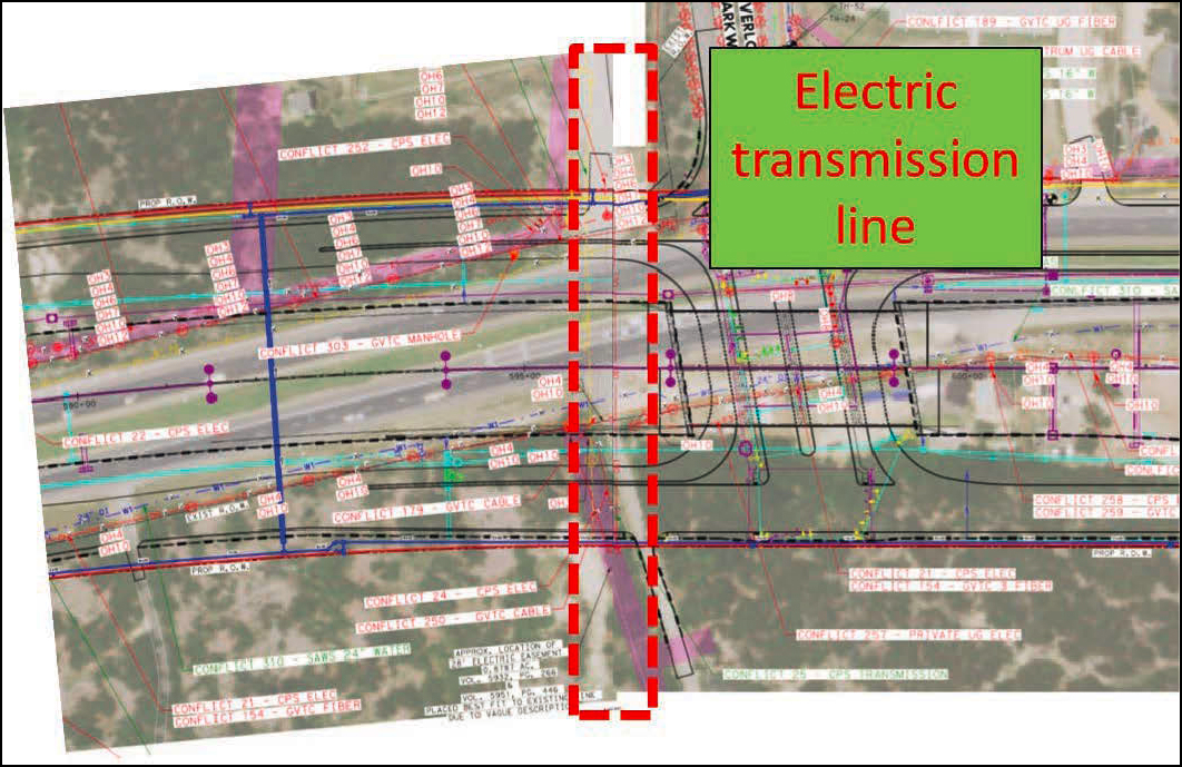
An early focus of the UCM implementation was to find opportunities to avoid unnecessary relocations. For example, an overhead electric transmission line crossing the highway was in conflict with an overpass (Figure 22). The overhead clearance was insufficient. The district considered two alternatives: (a) relocate the transmission line and (b) modify the final grade to avoid the transmission line. After considering the advantages and disadvantages of both alternatives, the district decided to lower the final grade. Part of the tradeoff analysis was to make sure that lowering the final grade would not affect minimum coverage requirements for an existing gas line at that location. Avoiding the transmission line resulted in an estimated savings of $3 million and 24 months of project delivery time.


Courtesy of the TxDOT.
A 24-inch water main running longitudinally was in conflict because it was too close to the southbound frontage road. The district considered two alternatives: (a) relocate the water main and (b) shift the frontage road alignment approximately 5 feet closer to the main lanes. After considering the advantages and disadvantages of both alternatives, the district decided to redesign the frontage road closer to the main lanes. Avoiding the water main resulted in an estimated $1.6 million in savings. Project delivery time savings were not significant because the relocation would have been included in the highway contract and the impact on construction schedule would have been negligible.
These two examples, as well as other instances in which the district avoided utility facilities, happened early during the preliminary design phase. As a lesson learned, the district did not discuss these resolution strategies with the affected utility owners and simply adopted those strategies on its own. Discussing with the utility owners how the district helped them avoid costly utility relocations would have been beneficial during the construction phase when the district encountered a few situations that required the water utility owner to be cooperative, but the utility owner was reluctant to participate actively.
Overall, the district quantified $4.6 million in economic savings and 24 months in project delivery time. The district also reported positive benefits from the implementation of the UCM approach at other projects.
In addition to avoiding existing utility facilities whenever possible, the district tried to complete utility relocations before letting. For Segment 2, the district used a right-of-way clearing contract to accelerate utility relocations prior to letting. This type of contract was relatively new at the department at the time the district used it for Segment 2. Given the positive results, TxDOT has since expanded it to other districts.
Construction Phase
For utility relocations that could not be completed prior to letting, the district staged the relocations to minimize impacts to the construction schedule. The district did not integrate utility relocation schedules into the contract schedule but did prepare an Excel file showing the planned relocations for all utility facilities. In addition, the district prepared a document to manage utility relocations during construction, called a construction management plan (CMP). CMPs have been required at TxDOT since 2016 in situations where a district estimates that complying with certifications and permit clearances is likely to extend beyond 3 months after letting (107). A CMP describes the sequence of highway construction that can be completed in conjunction with the outstanding certification and permit items. CMPs are applicable to any certifications or permits needing to be cleared after letting that will not be incorporated into the project construction but will be completed by a third party.
CMPs can be included in the highway contract at the discretion of the project manager. In the case of the US 281 project, the CMP was not included in the contract and therefore it was not enforceable. Nevertheless, the district indicated that compliance with the CMP was at 88 percent, meaning that 88 percent of utility relocations that were included in the CMP were completed on time according to the CMP. District officials indicated that this level of compliance was positive and encouraging.
As mentioned, although the project was designed in 3D, the bidding package contained 11×17-inch sheets containing 2D plan views, cross sections, and profiles. It is not clear whether the highway contractor received a copy of the 3D files. In practice, field personnel only used the 11×17-inch sheets. Feedback from the construction manager and CEI personnel indicates that having 3D files would have been beneficial during the construction phase.
For non-joint-bid relocations, the CEI consultant highlighted the need for extra coordination with utility owners because the contractor wanted to work on several fronts simultaneously (as opposed to south-north, as originally envisioned during the design phase). The consultant also highlighted the need for utility owners to be flexible during construction. In addition, it was critical to develop effective working relationships with utility contractors.
Some utility pole relocations were problematic. The typical staging process for poles involves the following steps:
- A utility owner technician prepares drawings depicting the approximate location of the poles. This step involves the use of a GIS-based platform that does not include accurate georeferencing. Although it was not immediately clear, it appears that these drawings are used to prepare and execute utility agreements.
- A utility owner representative goes to the field with this drawing to stake actual pole locations based on commonly accepted practices.
- A surveyor with the CEI consultant surveys the staked locations.
- An engineer overlays this information on project files and checks for conflicts with other utility facilities or project features such as culverts.
An issue in practice was electric utility contractors placing poles not according to previously staked locations (or agreed upon locations), but according to what was convenient to the utility contractor (e.g., moving the pole location a few feet so that their truck could access that location). Another issue was utility poles that were relocated prior to letting but were not shown on the plans the contractor received from TxDOT.
Poles near retaining walls required special attention. Although TxDOT staked the locations where poles were supposed to be installed, in a few cases the utility contractor placed the poles at a different location that put the poles in conflict with a new retaining wall. In these cases, the utility contractor had to move the new poles to the correct locations at no cost to TxDOT. The goal was to have poles at least 5 feet away from the excavation for any retaining wall because the utility owner required bracing for any excavation closer to 5 feet from an existing pole.
A few poles were in conflict with various project features, such as driveways, culverts, and drainage ditches. Each conflict was different and involved a different resolution strategy.
The district experienced a few, mostly minor, issues with communication facilities. In some cases, the issue was existing underground communication lines being too shallow, which put them in conflict with highway features or other utility facilities being relocated. In one case, it became necessary to postpone the relocation of several communication lines until the relocation of a gas line was complete. In other cases, overhead communication lines could not be relocated until the electric utility owner installed new poles to facilitate the relocation. Some delays in the relocation of communication lines also happened because the highway contractor had not yet finished installing poles for traffic signals.
For joint-bid relocations, the construction manager found the RFI process to be too slow (for effective utility coordination purposes) and found it be more expedited to coordinate with the utility contractor directly to anticipate issues. Weekly meetings helped them stay on top of things.
Most joint-bid relocation issues were related to constructability of water main relocations. At one location, the contractor could not find the tie-in point to the existing line despite conducting multiple test holes and slit trenches. It turned out the existing as-builts the utility owner had provided to its own consultant to design the relocation were incorrect (Figure 23). This consultant did not conduct test holes to verify the X-Y-Z coordinates of the tie-in points. Furthermore, the utility owner nor its consultant requested TxDOT to conduct test holes. In addition, the utility investigation was QLB in the area where the water main was going to remain in place, but then it was QLD in the area where the water main was going to be relocated. As a result, the utility consultant did not actually know where the tie-in point was. Instead, the consultant added a commonly used note on the plans requiring the contractor to locate the
nearest joint prior to fabrication of each tie-in closure piece, effectively transferring the risk to the highway contractor.

Courtesy of the TxDOT.
The research team has been involved with UCM implementations at all 25 TxDOT districts. In several cases, districts reported similar problems during construction, where the highway contractor had considerable difficulty finding utility infrastructure that should have been documented during the design phase. A lesson learned is to always require or conduct test holes during the design phase to confirm the X-Y-Z coordinates of critical components such as tie-in points.
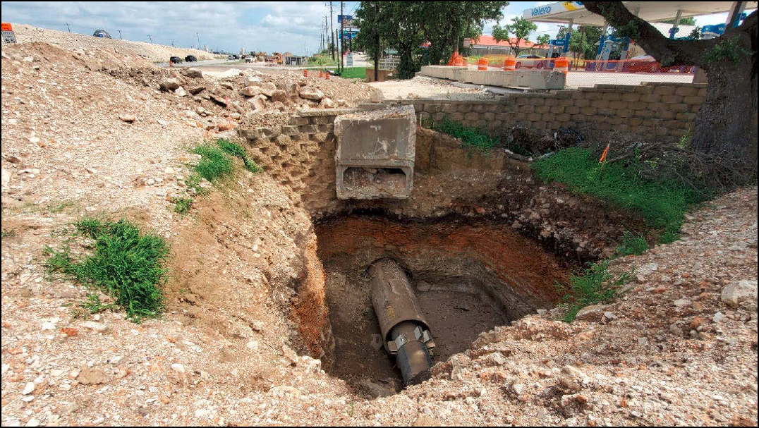
At another location that also involved a joint-bid relocation of the water main, the highway contractor proposed a jack and bore solution under an existing gas station driveway instead of digging an open trench as specified in the plans (Figure 24). The open trench excavation would have been too deep and close to the right-of-way line, making the total cost of relocating the water main too high, after accounting for shoring, removal on an existing box culvert, and removal and replacement of an existing block retaining wall in the cost estimate. The boring component would have been more expensive but would have resulted in net cost savings for the project. Unfortunately, the water utility owner refused to pay for the boring component on the grounds that boring was only at the convenience of the highway contractor and that accepting this cost would increase their monetary contribution. In the end, TxDOT approved the contractor’s request and absorbed the cost associated with the boring.
Courtesy of the Texas A&M Transportation Institute.
At several locations, the plans and specifications called for abandoning water lines. The water utility owner had a specification for abandoning facilities in place. The specification included grouting as part of the construction method description, but the payment section did not specifically say that grouting is a subsidiary item. The utility owner considered grouting to be a subsidiary item and refused to accept this cost.
At the same intersection where the conflict with the existing tie-in point was identified, another conflict involved an existing sanitary sewer (Figure 25). The contractor discovered that the actual alignment of the sewer was more to the south (i.e., to the left in Figure 25) than what the project plans showed, making the sanitary sewer in conflict with the piers for the proposed underpass. In addition, according to the plans, the sanitary sewer was supposed to be encased in a 30-in steel pipe under the existing right-of-way. However, the contractor did not find evidence of the casing. The utility investigation for the sanitary sewer was at QLB. A change order was necessary to correct the alignment of the sanitary sewer.

Courtesy of the TxDOT.
Change Orders
A review of change orders for Segments 1 and 2 revealed the following:
- For Segment 1, the total number of change orders was 41, of which 25 (or 61 percent) were UR and 16 (or 39 percent) were NUR. For Segment 2, the total number of change orders was 64, of which 21 (or 33 percent) were UR and 43 (or 67 percent) were NUR. Segment 2 is finalizing construction, so it is possible that the total number of change orders (mainly NUR), will increase. It is significant that the total number of change orders for Segment 2 was higher, but the number of UR change orders was lower. Further, the percentage of UR change orders decreased dramatically for Segment 2 compared to Segment 1 (33 percent versus 61 percent, respectively).
- The total dollar amount associated with change orders for Segment 1 was $15.9 million, of which $7 million (or 44 percent) were UR and $8.9 million (or 39 percent) were NUR. For Segment 2, the total dollar amount associated with change orders was $5 million, of
- which $1.5 million (or 29 percent) were UR and $3.5 million (or 71 percent) were NUR. The total dollar amount for change orders in Segment 2 was 69 percent lower than for Segment 1. This reduction is probably not reliable since final numbers are not yet available for Segment 2. However, the numbers for UR change orders are more reliable because most UR issues were addressed earlier during construction. For UR change orders, the total dollar amount associated with Segment 2 was 79 percent lower than for Segment 1. Readers should be aware that there is an element of uncertainty in this estimate because change orders often address multiple issues, making the isolation of any one issue quite difficult.
Overall, the change order numbers show that the UCM implementation, adding utility coordination and inspection to the scope of the CEI contracts, and other strategies (such as using a right-of-way clearing contract) had a positive impact on the management of utility issues both prior to letting and during construction.
VIRGINIA—HILLSBORO IMPROVEMENT PROJECT
Project Overview
The Town of Hillsboro, Virginia, undertook a 0.8 km (0.5-mi) project called ReThink9 (108). This project consisted of two roundabouts (one roundabout on either end of the project), raised crosswalks, sidewalks, a new municipal drinking water system, wastewater treatment facility, stormwater collection system, undergrounding all overhead utility lines, and dark-sky-compliant streetlamps (Figure 26, Figure 27). The project was completed in May 2021.The purpose of the project was to relieve congestion and improve traffic flow while enhancing safety for motorists and pedestrians. Route 9 is one of the region’s busiest commuter and tourist travel routes. The project was first proposed to mitigate congestion along the Route 9 corridor. However, the town’s water source was determined to be unsafe and its distribution system under Route 9 in need of replacement. Failing and inadequate private septic systems also posed an environmental threat. Addressing all traffic and infrastructure components simultaneously resulted in a significant reduction in the duration of impacts to traffic, residents, and businesses during construction.


The estimated construction cost was $12 million. However, bids came in at more than $20 million, which the town could not afford. The designers then changed the sequence of construction and prepared an updated maintenance of traffic (MOT) plan, lowering the construction schedule from 31 to 14 months. The original project included daily lane closures but was modified to include full two-lane closures. The resulting lane closure schedule was as follows:
- The roundabouts were built first. During this period, two-way traffic was allowed on Route 9.
- After the roundabouts were operational, one lane was open for eastbound traffic from 4AM to 9:30AM on weekdays. From 2PM on Friday to 6PM on Sunday, one lane was open for westbound traffic. After 6PM on Sunday, one lane was open for eastbound traffic until 9:30AM the following morning.
- The contractor could also close both lanes completely, without exceeding 60 days in total, in blocks of five days (minimum) and 30 days (maximum). In practice the contractor established two-lane closures in 600–1200 ft increments.
The MOT was revised in April 2020 to include additional local and regional detours, which were made possible during the COVID-19 pandemic.
With these modifications, the estimated cost decreased to about $15 million. The winning bid was $14.3 million. The Town of Hillsboro worked with VDOT to develop and deliver the project. VDOT hired a prime consultant to conduct preliminary engineering and detailed design work. This consultant was retained to provide construction management services. A subconsultant provided utility coordination services all the way from preliminary engineering to construction. The scope of work for this subconsultant included working closely with all stakeholders to develop a multitask sequence of utility work activities in conjunction with the roadway schedule.
Management of Utilities
One third of the project cost (or $5 million) was spent on utility and stormwater infrastructure, including 16,500 ft of communication conduits, 11,500 ft of electric conduits, new sanitary sewer and laterals, 6,000 of stormwater drainage pipes, 100 stormwater structures, and utility vaults and manholes. The project included strategies to build utility systems in a narrow roadway, utility coordination for relocation work, and close coordination for consecutive and concurrent relocation work. It also included preparation of utility as-builts using RFID devices.
VDOT normally relocates utility facilities prior to letting. In this project, utility facilities were relocated during construction to reduce impacts to the town. The contractor used the same MOT for utility construction and roadway construction. In practice, construction staging involved a significant amount of coordination between the contractor and each utility owner involved. This coordination included temporary poles, which enabled construction of the roundabouts, then staged construction of the communication duct bank, running communication cables through the duct bank, removing old overhead cables, and removing existing poles, while the contractor was also working on drainage and roadway features. Once two-lane closures started, the pace of the construction quickened, including both roadway and utility relocation work. The temporary poles
that facilitated the construction of the roundabouts cost about $100,000, but officials concluded that this expense was worth the investment.
Upgrading the electric distribution system included a strategy to upgrade electrical meters and panels at residential homes because many of these components were not up to code. The town managed this part of the project through a separate contractor in coordination with property owners and the electric utility provider.
Use of RFID Markers
As mentioned previously, VDOT started the RFID program to mark newly installed utility installations to reduce the level of uncertainty with respect to these facilities and, more specifically, as a damage prevention strategy. The current protocol at VDOT enables the collection of X-Y-Z data at pre-specified intervals, enabling managers to generate an inventory of those facilities. For the Hillsboro project, it was of interest to document X-Y coordinates, but not necessarily elevations because roadway and utility work occurred simultaneously. For other projects in which utility relocation occur prior to letting, documenting elevations is critical.
RFID readers cannot detect tags beyond 1.8 m (6 ft). As a result, VDOT installed RFID marker balls at 0.9–1.2 m (3–4 ft) deep, directly above the utility facility of interest. After completing the backfill operation, a locator found the balls and captured their X-Y coordinates. The horizontal positional accuracy of the GNSS antenna was about 15 cm (6 inches). After gathering the information in the field, VDOT generated as-built polylines that provided a visual representation of the utility alignments and prepared as-built PDF files containing plan and profile information along with RFID marker locations and attribute data.
Change Orders
The only UR change orders were related to concrete in the duct banks. At some locations, the contractor found big boulders that had to be removed, resulting in more concrete than what had originally been estimated. At other locations, particularly around manholes, the contractor excavated more than what was necessary, but the specifications did not require the contractor to have more control over the duct bank cross section. After connecting the duct bank to the manholes, the contractor poured concrete to encase the duct bank around the connections, but the total volume of concrete used exceeded the original estimate. A lesson learned was to have the amount of concrete as a subsidiary item to the construction of manholes or, alternatively, as a lump sum item.
As a direct result of the MOT plan based on full road closures, utility relocation costs were lower than what had been estimated. In one case, the actual cost was almost $300,000 less than the original estimate. In another case, the actual cost was $26,000 less than the original estimate.


