Community Corner
7 Weird Rock Formations To Visit In California: Man-Made Or Erosion?
From arches to strange "tufa towers," we found these unique rock formations that are "must-visit" for hikers and climbers heading to CA.

CALIFORNIA — If you are a "rock nerd" living in California or just love learning about geology, we've found some of the most unique rock formations in the Golden State. While some may appear man-made, they are all created by geologic events.
We focused on our top seven rock formations, knowing these are a mere handful of pebbles compared to the mountain of geologic wonders to visit across the Golden State. Each of these geologic marvels was carved from the earth through earthquakes, volcanic incidents, or weathering that took a mind-blowing number of years to become what we see today.

1. Devil’s Postpile National Monument - You may have scrabbled around the unique volcanic rock formation on the way to see the Rainbow Falls of Mammoth Lakes. This geologic wonder became protected as a National Park in 1911 by presidential proclamation. “Devils Postpile National Monument protects and preserves the Devils Postpile formation, the 101-foot high Rainbow Falls, and pristine mountain scenery. The formation is rare in the geologic world and ranks as one of the world's finest examples of columnar basalt. Its columns tower up to 60 feet and display a striking symmetry.”
Find out what's happening in Palm Desertwith free, real-time updates from Patch.

2. Half Dome, Yosemite - Half Dome is the pinnacle postcard photo of Yosemite and what the famed “Go Climb A Rock” t-shirts are all about. Hiking Half Dome is a goal of many climbers, and one they insist is the only way to see the entire Yosemite Park, but you’ll need a permit for that. The edifice rises nearly 5,000 feet above the Valley floor and lures climbers to seek its summit each year. “In 1865, this granite dome was considered 'perfectly inaccessible,' but thousands of Yosemite hikers now reach the top each year by following a strenuous trail from the Yosemite Valley floor," according to the National Park Service website. "The final 400-foot ascent, up the peak's steep east face, follows a pair of steel cables raised on posts that lead to the breathtaking summit. This cable route was constructed in 1919 by the Sierra Club for visitors without technical rock climbing ability. Using the Half Dome Cables is a unique experience, and it has become one of the most popular hikes in Yosemite National Park.”

3. Ubehebe Crater: Within the breadth of California's Death Valley are unique rock formations, from the carved-out ghost town in the volcanic caliche of Dublin Gulch to the unusual deep bowl of the Ubehebe Crater. “The crater was created by a powerful volcanic steam explosion,” according to the National Park Service website. This is a Maar volcano, created by steam rising from magma reaching ground-depth water. Geologists say the most recent of these on the west coast, the Ubehebe crater, was likely formed 2,1000 years ago. The crater is 600 feet deep and half a mile across. Walking down the crater is considered easy while getting back up to the top "can be exhausting," experts say. Consider walking the rim, and see the smaller cinder cone craters, often called "Little Hebe."
Find out what's happening in Palm Desertwith free, real-time updates from Patch.
.jpg)
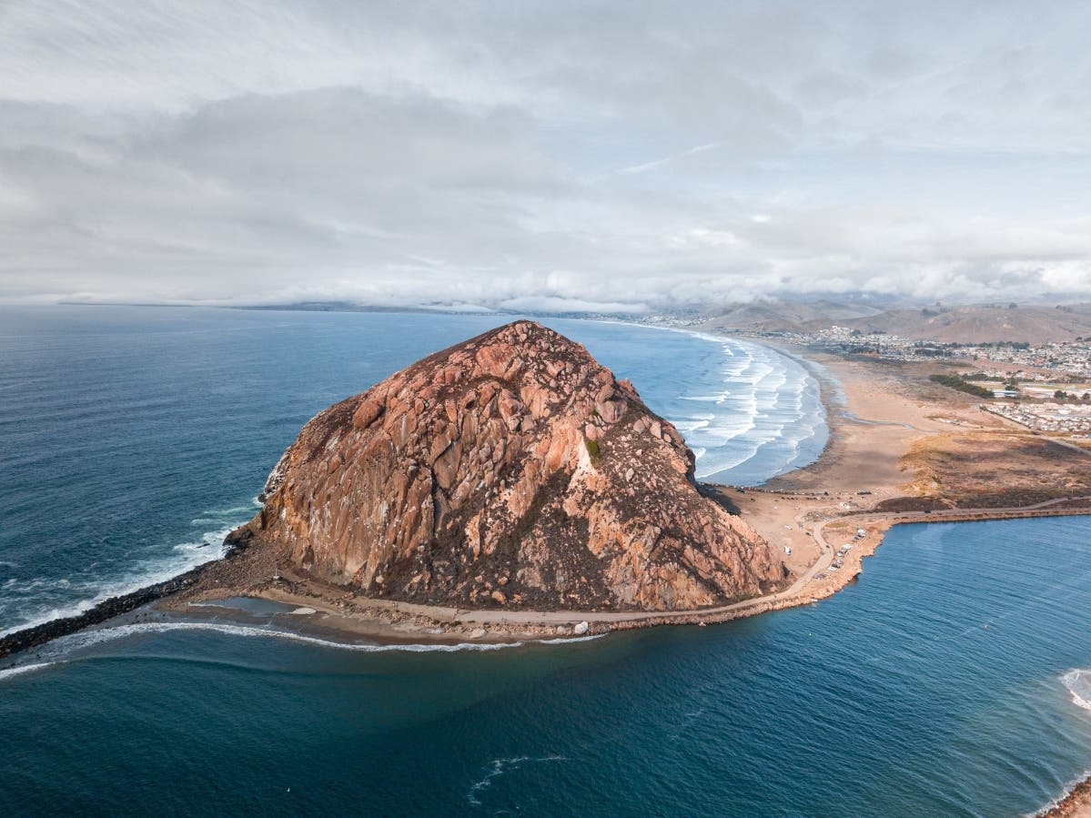
4. Morro Rock: Morro Rock, situated above Morro Bay on the Central California coast, is often called the "Gibraltar of the Pacific," a Morro Bay city spokesperson writes. The rock is an estimated 23 million years old, and all that remains of an ancient volcano, but it evolved into an important navigational landmark for explorers and sailors. In 1542, a Portuguese explorer named the rock, with Morro translated to "crown-shaped hill." This is the last peak of the Nine Sisters, extending from San Luis Obispo to Morro Bay. According to the city, it is a state landmark and a bird sanctuary known to be a breeding ground for sea birds and peregrine falcons and a beloved location to spy sea otters.

5. Crowley Lake Columns: Otherworldly in appearance, the Crowley Lake columns were carved naturally out of tons of pumice and ash “caliche.” Many columns are still buried in the sand, while others resemble medieval collonades. According to UC Berkeley geologists, they were created by snowmelt meeting hot ash layers, creating steam following a “cataclysmic explosion 760,000 years ago,” according to thatadventurelife.com. A 4WD is needed to reach the spot, as is a steep hike, detailed by visitors. "Crowley Lake Columns are a must-see for anyone intrigued by nature’s unpredictable artistry," according to California.com. "(The columns) stand a poignant reminder of the Earth's incredible ability to craft wonders over extensive periods. Their formation story teaches us about the power of nature's forces – from the fiery rage of a volcano to the slow, persistent drip of melting snow."

6. Potato Chip Rock - This wafer-thin slice of granite is thicker than it looks. Jutting out across the void, Potato Chip Rock formed when a boulder beneath rolled down the slope, leaving a slice behind. It's a favored local photo spot for San Diego area hikers. It's considered "out of the way" on a 7.3-mile hike near Poway, in San Diego County, by AllTrails.com, offering a death-defying illusion and views of the Pacific Ocean. "Those brave enough to walk across the ledge will appear to levitate above the ground below, as if on a magic carpet made of stone," says Atlas Obscura. Considered “moderately challenging” for a hike, according to alltrails.com, it takes about four hours to reach the sliver of rock jutting out over the divide. Bring plenty of water and sunscreen when you go, and turn around once you are halfway through your water supply. The AllTrails experts say that “although the trails remain open year-round, this is not recommended for less experienced hikers during hot weather.”

7. Mono Lake Tufa State Reserve: If you’re driving on Highway 395 near the Lee Vining, take a sidetrip to see one of the most intriguing sights in the Golden State. Set against the backdrop of the Eastern Sierra mountains, the lake reflects giant “tufa towers.” According to a Mono County spokesperson, these calcium-carbonate “spires” are formed where fresh and saltwater merge and are part of the unique habitat that shelters up to two million birds every year. The ancient lake covers 65 miles, and has no outlet. Be sure to visit the visitor center and learn more about the formations when you go and learn more about the geology of the eastern Sierras if you choose, or just take it all in as you drive through the spires of the mountains.
Also See:
Get more local news delivered straight to your inbox. Sign up for free Patch newsletters and alerts.