Home & Garden
Minor Snow Accumulation Possible for Woodbury, Middlebury
There's a chance we could see some Sunday snow on the ground. Additional chances of snow are also in the forecast.

First, we’re not talking a lot of snow for Connecticut but the fact that the National Weather Service is predicting some sort of snow accumulation late Saturday into early Sunday is still noteworthy.
Only in New England do you go from near 70 degrees Friday, with rain and thunderstorms, to light snow and snow showers 24 hours later.
The National Weather Service also says more snow is possible for the entire state on Monday, as well as Wednesday into Thursday. Before we get to the snow chance this weekend, we’re looking at showers and thunderstorms off and on during the day Friday. Fog may also an be an issue, especially early on Friday.
Saturday will be mostly cloudy with some showers and temps in the mid-50s, before the winds come and the temps drop. We may see some snowflakes.
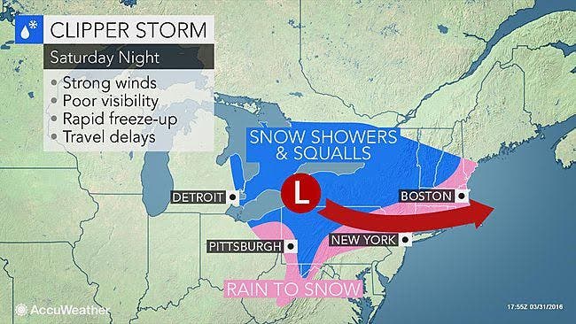
The Latest NWS Forecast
A Hazardous Weather Outlook has been issued for Hartford and Tolland counties for a period of snow, which may be heavy for a time, and could produce a few inches of snow in short period of time late Saturday into Sunday morning. Winds are expected to be strong here too.
Southern Connecticut has a High Wind Watch in effect from late Saturday night through Sunday morning, with winds 20 to 30 mph and gusts up to 55 mph. The winds could be severe enough to take down trees and power lines, the weather service writes.
For Fairfield, New Haven, Middlesex, and New London counties, no Hazardous Weather Outlook has been issued for snow accumulation, but we may see some snow on the ground by mid-Sunday morning.
Projected Accumulation
On the immediate Connecticut coastline, from Greenwich to New London, we could see between a half-inch up to an inch of snow on the ground. But more interior sections of Fairfield, New Haven, Middlesex, and New London counties may see 1-2 inches of snow accumulation.
Again, no need to run out and buy gallons of milk and loaves of bread, but winter isn’t over yet.
Connecticut's Weather Experts Weigh In
NBC Connecticut Meteorologist Ryan Hanrahan writes, “It looks like we get some snow on Sunday morning (maybe even a heavy squall and flash of lightning) but it's nothing that unusual. In fact, measurable snow has occurred 104 times in the last 112 years in the Hartford area (in April).”
WTNH News 8 Meteorologist Gil Simmons writes, “Lots of clouds today with a few scattered rain showers. High temperatures will be in the low 60s at the shoreline, around 70 inland. Enjoy the warmth! A brutal cold front will come through Saturday night and Sunday morning with snow showers that could cover the ground in some spots and a very windy chill all day on Sunday.
Timing of the Snow Showers
Rain showers will begin after midnight on Saturday and change to snow showers after 2 a.m., continuing until mid-morning Sunday. Temps will rise above freezing on Sunday and the snow that does stick will likely melt away quickly.
On Monday, southern Connecticut may see a mix of rain and snow showers throughout the day and then it’s snow at night. Hartford and Tolland counties may see all snow. Monday. No accumulation estimates are available yet.
And yes, more snow is possible Wednesday into Thursday. Happy Spring, everyone!
Get more local news delivered straight to your inbox. Sign up for free Patch newsletters and alerts.