Weather
Flooding Possible With FL Storms; Heat Index Values Could Near 110
Northeast and northern Florida will be under a heat advisory Monday while much of the state could experience daily storms.

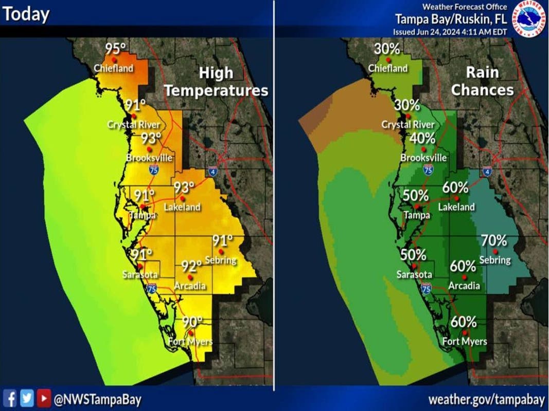
FLORIDA — More rainfall is expected to fall throughout the week across Florida as daily sea breeze showers and storms are forecast in Tampa Bay and surrounding areas, forecasters told Patch Monday.
Patch spoke with Ross Giarratana, a meteorologist with the National Weather Service's Tampa Bay office, which covers central, west central and southwest Florida.
Giarratana said while no severe weather is anticipated, forecasters are monitoring some areas for potential localized flooding. This includes southwest Florida, where soils remain slightly wet from weekend sea breeze thunderstorms.
Find out what's happening in Tampawith free, real-time updates from Patch.
Areas that receive torrential downpours could be at risk for flooding though no alerts had been issued as of early Monday afternoon.
Aside from flooding, gusty winds could be possible with some strong storms, Giarratana said. Lightning may occur with some storms.
Find out what's happening in Tampawith free, real-time updates from Patch.
"We’ll be looking at very typical summertime storms in our area," he said.
Near Miami, a hazardous weather outlook stated scattered thunderstorms with potentially localized flooding was possible Monday for areas in southeast, southern and southwest Florida and areas near the Gulf of Mexico.
Heavy rainfall and gusty winds could be concerns with these storms, according to the outlook. Then, scattered thunderstorms could arrive daily in the area.
In the Orlando area, several scattered showers and scattered lightning storms were forecast for Monday. Frequent lightning strikes, heavy rainfall and localized wind gusts up to 35 mph are potential hazards with these storms.
Rainfall amounts of 1-3 inches could pour into the area, and there is a moderate risk of life-threatening rip currents at all central Florida Atlantic beaches Monday, weather officials said.
Storms are not the single factor impacting Florida weather this week. Hot temperatures may also be concerning for the Sunshine State.
A heat advisory is in effect from 1-7 p.m. Monday for Jacksonville, St. Augustine and surrounding areas as heat index values of up to 109 degrees are expected in northeast and northern Florida.
"Hot temperatures and high humidity may cause heat illnesses," weather officials said in the advisory.
Miami could feel heat indices between 100 and 105 degrees Monday, with values possibly rising to 110 degrees later in the week.
A moderate heat risk exists Monday for east central Florida. Temperatures are expected to sit in the low to mid-90s. Heat index values could climb to 105 degrees.
The moderate heat risk could transition to major in coming days in east central Florida.
"It is recommended to take frequent breaks out of the sun and drink plenty of water
during the hottest part of the days," weather officials said.
As of around 12:30 p.m. Monday, the National Weather Service predicted the following forecast for Tampa Bay:
This Afternoon: A 50 percent chance of showers and thunderstorms. Mostly sunny, with a high near 91. Heat index values as high as 98. Southwest wind 3-6 mph. New rainfall amounts between a tenth and quarter of an inch, except higher amounts possible in thunderstorms.
Tonight: Showers and thunderstorms likely, mainly before 1 a.m. Partly cloudy, with a low around 78. West southwest wind around 5 mph becoming calm in the evening. Chance of precipitation is 60 percent. New rainfall amounts between a tenth and quarter of an inch, except higher amounts possible in thunderstorms.
Tuesday: A chance of showers and thunderstorms before 11 a.m., then showers likely and possibly a thunderstorm between 11 a.m. and 2 p.m., then scattered showers and thunderstorms after 2 p.m. Mostly sunny, with a high near 92. Heat index values as high as 102. Calm wind becoming west southwest around 6 mph in the afternoon. Chance of precipitation is 70 percent. New rainfall amounts between a tenth and quarter of an inch, except higher amounts possible in thunderstorms.
Tuesday Night: Scattered showers and thunderstorms, mainly after 2 a.m. Partly cloudy, with a low around 78. West wind around 5 mph becoming calm in the evening. Chance of precipitation is 30 percent.
Wednesday: Scattered showers and thunderstorms. Mostly sunny, with a high near 92. Calm wind becoming west 5-7 mph in the afternoon. Chance of precipitation is 50 percent.
Wednesday Night: Isolated showers and thunderstorms. Partly cloudy, with a low around 79. West wind around 6 mph becoming calm in the evening. Chance of precipitation is 20 percent.
Thursday: Scattered showers and thunderstorms. Mostly sunny, with a high near 91. West wind 3-8 mph. Chance of precipitation is 40 percent.
Thursday Night: Scattered showers and thunderstorms, mainly after 2am. Partly cloudy, with a low around 78. West wind around 6 mph becoming calm in the evening. Chance of precipitation is 30 percent.
Friday: Scattered showers and thunderstorms. Mostly sunny, with a high near 93. Calm wind becoming west southwest 5-7 mph in the afternoon. Chance of precipitation is 50 percent.
Friday Night: Isolated showers and thunderstorms. Partly cloudy, with a low around 78. Chance of precipitation is 20 percent.
Saturday: Scattered showers and thunderstorms. Mostly sunny, with a high near 94. Chance of precipitation is 40 percent.
Saturday Night: Scattered showers and thunderstorms. Partly cloudy, with a low around 78. Chance of precipitation is 30 percent.
Sunday: Scattered showers and thunderstorms. Mostly sunny and hot, with a high near 95. Chance of precipitation is 50 percent.
Get more local news delivered straight to your inbox. Sign up for free Patch newsletters and alerts.


