Weather
'Long Term' Heat Advisory Issued For Twin Cities Metro: MN Weather
The National Weather Service has issued a "long term" heat advisory for the Twin Cities metro area.

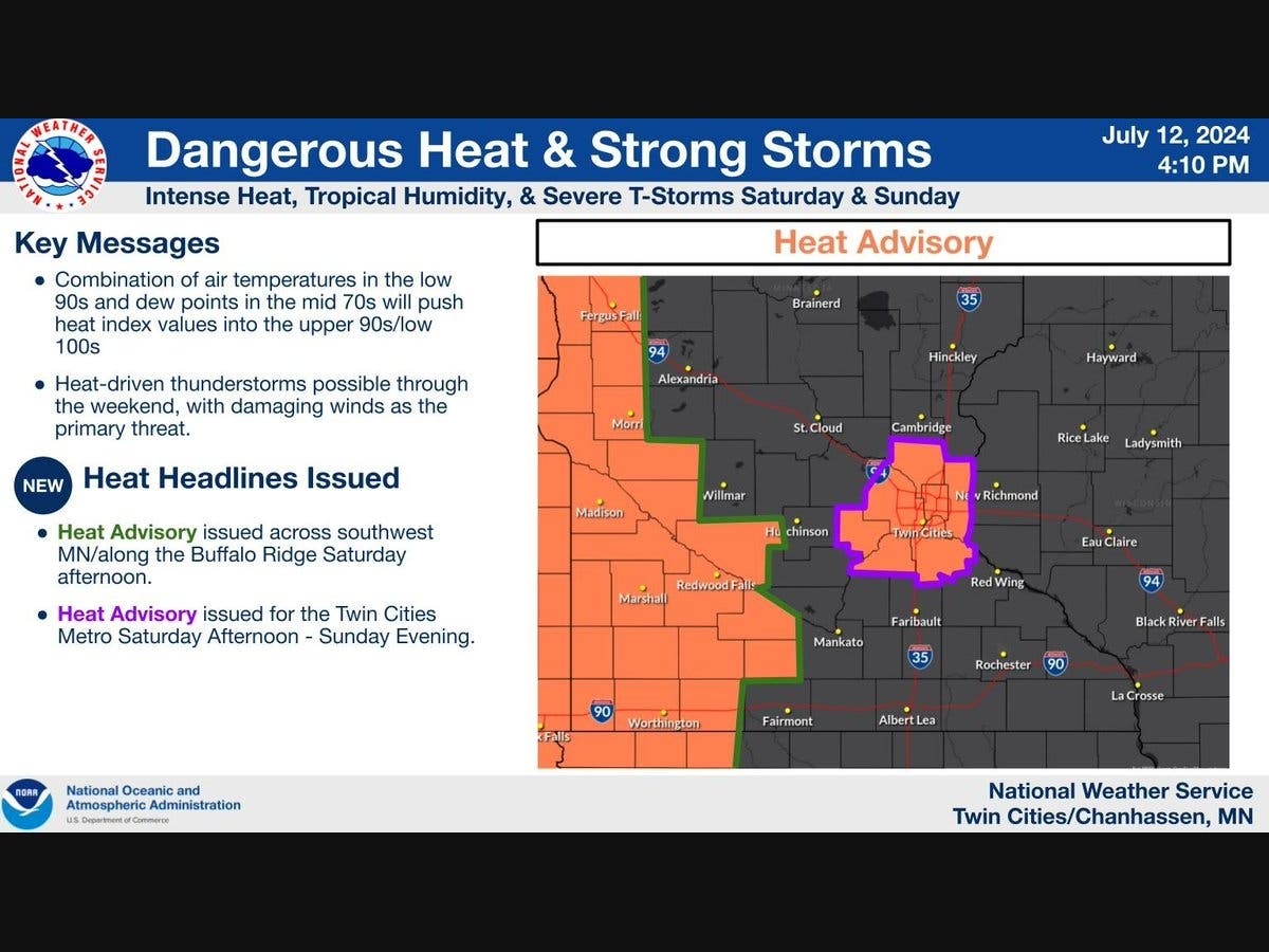
TWIN CITIES, MN — The National Weather Service has issued a "long term" heat advisory for the Twin Cities metro area. The heat advisory will last from 2 p.m. Saturday to 8 p.m. Sunday.
The metro is expected to see heat index values near 100 degrees in the afternoons. The lows will hang in the mid-70s.
The counties included in the advisory are: Anoka, Carver, Dakota, Hennepin, Ramsey, Scott, and Washington.
Find out what's happening in Minneapoliswith free, real-time updates from Patch.
"Drink plenty of fluids, stay in an air-conditioned room, stay out of the sun, and check up on relatives and neighbors. Take extra precautions when outside," the National Weather Service said.
"Wear lightweight and loose fitting clothing. Try to limit strenuous activities to early morning or evening. Take action when you see symptoms of heat exhaustion and heat stroke."
Find out what's happening in Minneapoliswith free, real-time updates from Patch.
Here's the full NWS forecast from the Minneapolis-St. Paul Airport:
Saturday: A 30 percent chance of showers and thunderstorms, mainly before 1pm. Partly sunny, with a high near 91. Heat index values as high as 96. South wind around 10 mph.
Saturday Night: A 30 percent chance of showers and thunderstorms, mainly between 10pm and 1am. Partly cloudy, with a low around 74. South wind 5 to 10 mph.
Sunday: Sunny, with a high near 91. Heat index values as high as 96. Southwest wind around 5 mph becoming north in the morning.
Sunday Night: A 20 percent chance of showers and thunderstorms after 1am. Increasing clouds, with a low around 72. Southeast wind around 5 mph.
Monday: A 30 percent chance of showers and thunderstorms. Mostly sunny, with a high near 87. Southeast wind 5 to 15 mph becoming west northwest in the morning.
Monday Night: Mostly clear, with a low around 66. North northwest wind 5 to 10 mph.
Tuesday: Sunny, with a high near 80. North northwest wind 5 to 10 mph.
Tuesday Night: Mostly clear, with a low around 61. North wind 5 to 10 mph.
Wednesday: Sunny, with a high near 78. North wind 5 to 10 mph.
Wednesday Night: Mostly clear, with a low around 60. North wind 5 to 10 mph becoming light east northeast after midnight.
Thursday: Sunny, with a high near 79. Southeast wind around 5 mph.
Thursday Night: Partly cloudy, with a low around 62. South wind around 5 mph.
Friday: Mostly sunny, with a high near 82. South wind around 5 mph.
Get more local news delivered straight to your inbox. Sign up for free Patch newsletters and alerts.