Home & Garden
What If Winter Never Comes In Toms River?
Winter weather has (so far) been historically warm. Will it ever get cold?

If you’ve been staring at the sky lately, holding out hope for some snowflakes to fall, you’ve probably been disappointed.
For most of the United States, it’s been a warmer-than-average holiday season so far.
Find out what's happening in Toms Riverwith free, real-time updates from Patch.
Take Buffalo, New York, for example. (Please.) It has never, since records on this kind have been recorded, waited this far into the year for snow. New York, Boston, Philadelphia and Washington, D.C. — all cities that should have received a dusting by now, at least — haven’t seen any snow yet.
More than 140 record highs have been set this week alone, the Weather Channel’s Alex Wilson told Patch, with just one record low.
Find out what's happening in Toms Riverwith free, real-time updates from Patch.
And relief doesn’t appear to be in sight.
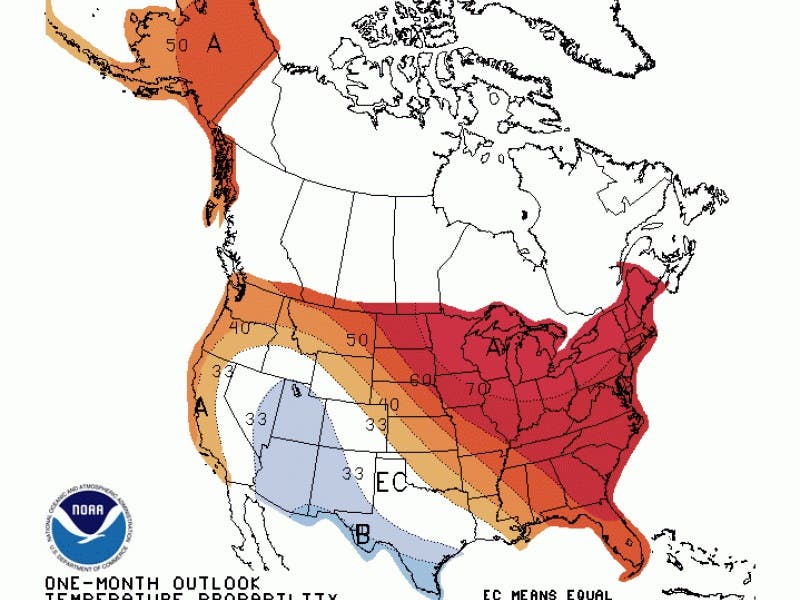
The National Weather Service’s December temperature predictions are calling for more of the same: warmer-than-normal temperatures for the majority of the United States, especially along the east and west coasts.
Several different factors are in play causing this winter weather (or lack thereof), but the biggest is an historic El Niño.
Put simply: El Niño is a climate pattern that starts with unusually warm waters in the pacific ocean, causing storms and mudslides to some places and droughts to others.
But El Niño also typically causes warm weather in California, the northern plains and the east coast, with colder temperatures in the Rockies and parts of Texas — consistent with the predictions from the National Weather Service.
And 2015’s El Niño is approaching the strongest ever recorded, as measured by sea surface temperatures.
“Longer term we may tend towards a warmer regime, but we can certainly still have serious bouts of cold during the winter,” the Weather Channel’s Carl Parker told Patch. “This pattern has occasionally looked like the historical analogs of the strongest El Niño events, at least in terms of temperatures.”
In addition to El Niño, Wilson said the jet stream is causing the extremely cold arctic air to get “stuck” up in Canada.
“We’re getting warmer winter weather because the very cold arctic air is stuck well up to the north — over the Canadian border,” she said.
“The jet stream position will not change much for the central and eastern part of the U.S. While the jet stream will dig south out west, allowing for some colder air to sink into that region, the central and eastern U.S. will remain under a ridge as the jet stream stays north — and highs will be 10 to 20, even 30 degrees above average.”
This year is also on pace to be, yet again, the warmest on record globally, Parker said.
So is there any relief (at least for winter weather lovers) in sight? Yes and no, experts say.
“In the short term, there are signs of a cool down to more normal conditions for this time of the year across the Northeast beginning next Thursday and running through the weekend,” the Weather Channel’s Winter Weather Expert Tom Niziol said. “In fact, I would not be surprised to see some snow in the Northeast Friday into Saturday of next week.
“However, that cold air does not stick around for long as temperatures are expected to rebound again as we head toward Christmas Day.”
Image via National Weather Service
Get more local news delivered straight to your inbox. Sign up for free Patch newsletters and alerts.