Weather
Thunderstorms Rock Long Island: Crashes, Power Outages Reported
BREAKING: The roads are a mess as powerful storms are leading to crashes and flooding. Send photos of storm damage to [email protected]

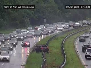
LONG ISLAND, NY — A line of powerful thunderstorms moved across Long Island Thursday morning, causing power outages, rush hour crashes and waking young children much earlier than their parents would like.
As of 7:45 a.m., PSEG Long Island says about 2,300 of its customers are without power as wind gusts of up to 50 mph lashed the region. Almost all of those outages are in Nassau County.
Incidents reported on major roads in the area:
Find out what's happening in Medfordwith free, real-time updates from Patch.
- Crash on NY 27 eastbound between Exit 39 - Hubbards Lane (Suffolk) and Exit 40 - NY 231; Babylon Northport Expressway (Suffolk) right and center lanes closed
- Crash on Southern State Parkway eastbound east of Exit 33 - NY 109 (Babylon) 1 lane may be blocked
- Crash on Northern State Parkway eastbound between Exit 30 - I U Willets Road (North Hempstead) and Exit 31 - Glen Cove Road (North Hempstead) left lane and shoulder closed
- Crash on Northern State Parkway westbound area of Exit 37 - Manetto Hill Road (Oyster Bay) 1 lane may be blocked
- Downed tree on NY 25A eastbound at Cold Spring Road (Oyster Bay) right lane and shoulder blocked
- Crash on I-495 westbound at Exit 19 - Woodhaven Boulevard / Queens Boulevard (New York) 1 Right lane of 2 lanes blocked
- Crash on Jericho Turnpike, eastbound, west of Caleb Smith State Park in Smithtown. Use caution in the area.
The Long Island Rail Road is in pretty good shape with just minor delays reported on the Ronkonkoma Branch.
The full forecast:
Find out what's happening in Medfordwith free, real-time updates from Patch.
Thursday- Showers and thunderstorms before noon, then a slight chance of showers between noon and 2pm. Some of the storms could produce gusty winds and heavy rain. High near 83. Breezy, with a south wind 11 to 20 mph becoming west in the afternoon. Chance of precipitation is 90%. New precipitation amounts between a tenth and quarter of an inch, except higher amounts possible in thunderstorms.
Thursday Night- Mostly clear, with a low around 61. Northwest wind 6 to 11 mph.
Friday- Sunny, with a high near 80. West wind 8 to 14 mph.
Friday Night- Increasing clouds, with a low around 62. Southwest wind 5 to 8 mph becoming calm after midnight.
Saturday- A 50 percent chance of showers, mainly after noon. Mostly cloudy, with a high near 74. Light and variable wind becoming southeast 5 to 7 mph in the morning.
Saturday Night- A 40 percent chance of showers before 2am. Mostly cloudy, with a low around 60.
Sunday- A 30 percent chance of showers after 2pm. Partly sunny, with a high near 76.
Sunday Night- A 30 percent chance of showers. Mostly cloudy, with a low around 62.
Monday- Mostly sunny, with a high near 78.
Monday Night- Partly cloudy, with a low around 61.
Tuesday- Mostly sunny, with a high near 79.
Get more local news delivered straight to your inbox. Sign up for free Patch newsletters and alerts.


