Home & Garden
Arctic April: Freezing Temperatures, Snow, 60 MPH Winds Possible in Hudson Valley
Today will be the last decent weather day for awhile before rain, thunderstorms, wind, an arctic blast and some snow all come to visit.

Savor today, it’s looking to be the best weather day for what may seem like a long, long time.
Today is a typical spring day, mostly sunny and temps in the mid- to upper-60s and low-70s are possible.
And then around midnight Mother Nature seemingly flips a switch on us and we’re dealing with spring’s showers, gusty winds and thunderstorms.
Find out what's happening in New Rochellewith free, real-time updates from Patch.
“A storm system will approach from the west Thursday night, and bring unsettled conditions and the chance of showers overnight,” said Bill Potter of Hudson Valley Weather.
“A rumble of thunder can’t be ruled out, as the atmosphere will be very spring-like, and a bit unstable,” he said.
Find out what's happening in New Rochellewith free, real-time updates from Patch.
For Friday, the unsettled conditions will continue. Scattered showers and thunderstorms are possible well into the afternoon. Highs will be in the upper-60s. It will get down close to freezing Friday night.
There is a chance of showers on Saturday and temperatures will only make it into the mid- to upper-50s.
The big question is whether or not there will be snow Saturday night. The forecast temperatures call for it to get close to freezing, so it could happen. And there is also the possibility of 50 to 60 mph winds behind the arctic cold front that will pass through.
From Sunday through Wednesday, don’t expect the high temperatures to get out of the 40s, with overnight lows dipping to the mid- to upper-20s.
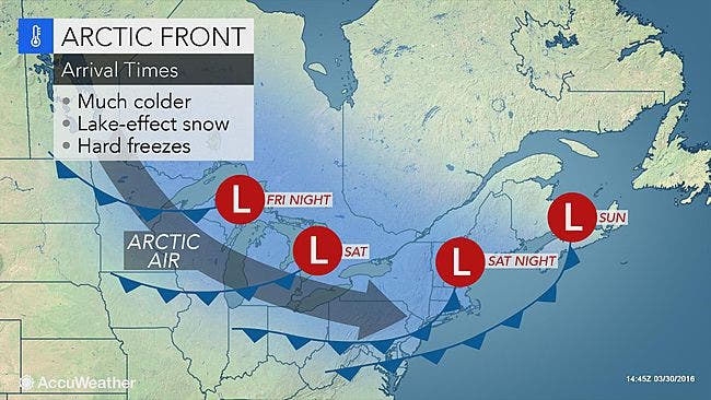
Map: AccuWeather.com
Get more local news delivered straight to your inbox. Sign up for free Patch newsletters and alerts.