Weather
Severe Thunderstorms Thursday In NoVA, DC: Timing, Forecast
Scattered or numerous showers and thunderstorms could impact the region on Thursday, according to the National Weather Service.

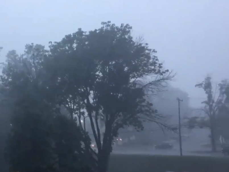
VIRGINIA — Severe weather is expected in the Northern Virginia and DC region Thursday, according to the National Weather Service's Baltimore-Washington office.
NWS issued a severe thunderstorm watch until 9 p.m. Thursday. Forecasters believe "conditions are favorable for severe thunderstorm development" in the watch area. A severe thunderstorm watch means large hail, damaging winds, dangerous lightning and occasional tornadoes are possible. Residents should monitor conditions and be prepared if a thunderstorm warning is issued.
"The main threat is damaging wind gusts, though a tornado cannot be ruled out," the NWS forecast states.
Find out what's happening in Viennawith free, real-time updates from Patch.
The severe thunderstorm watch applies to the greater region, including the Virginia counties of Fairfax, Arlington, King George, Spotsylvania, Loudoun, Prince William and Stafford as well as the cities of Alexandria, Falls Church, Manassas Park, Fairfax and Manassas. The possible timing for severe thunderstorms is 3 p.m. through mid-evening.
Just outside of Northern Virginia and DC, a flash flood watch has been issued for northeastern Maryland. NWS says this is where the flooding threat is highest, although isolated flooding incidents can happen outside the watch area.
Find out what's happening in Viennawith free, real-time updates from Patch.
A Severe Thunderstorm Watch has been issued for areas near and east of the Blue Ridge Mountains until 9pm tonight. Main threats will be for damaging winds, flash flooding and an isolated tornado. pic.twitter.com/OVDaGISVVB
— NWS Baltimore-Washington (@NWS_BaltWash) June 3, 2021
Forecasters say scattered thunderstorms are possible Friday afternoon as well. Some of these storms could cause damaging wind gusts. The weather could clear up in time for a pleasant weekend.
Here is the NWS forecast for the upcoming days in DC:
Thursday: Scattered showers and thunderstorms, mainly after 4 p.m. Some storms could be severe, with damaging winds and heavy rain. Mostly cloudy, with a high near 84. South wind 10 to 14 mph, with gusts as high as 20 mph. Chance of precipitation is 30 percent. At night, showers and thunderstorms are likely, mainly before 9 p.m. Some storms could be severe, with damaging winds and heavy rain. Cloudy, with a low around 68. Southwest wind around 9 mph. Chance of precipitation is 60 percent.
Friday: A chance of showers and thunderstorms, mainly after 8 a.m. Mostly cloudy, with a high near 82. West wind around 7 mph. Chance of precipitation is 50 percent. At night, a chance of thunderstorms before 8 p.m, and partly cloudy with a low around 64. Southwest wind 3 to 5 mph. Chance of precipitation is 30 percent.
Saturday: Sunny, with a high near 90. West wind 3 to 6 mph. At night, mostly clear, with a low around 67.
Sunday: Sunny, with a high near 93 and mostly clear at night with a low around 70.
Monday: Mostly sunny, with a high near 93 and partly cloudy at night with a low of 71.
Tuesday: A chance of showers and thunderstorms. Mostly sunny, with a high near 93 and low of 71. Chance of precipitation is 30 percent.
Get more local news delivered straight to your inbox. Sign up for free Patch newsletters and alerts.